Updated 06.21.21 @ 5:58p
You must be logged in to view this content. Click Here to become a member of IndyWX.com for full access. Already a member of IndyWx.com All-Access? Log-in here.

Jun 21
Updated 06.21.21 @ 5:58p
You must be logged in to view this content. Click Here to become a member of IndyWX.com for full access. Already a member of IndyWx.com All-Access? Log-in here.
Permanent link to this article: https://indywx.com/2021/06/21/evening-update-concern-growing-for-renewed-flash-flooding-this-weekend/
Jun 21
Updated: 06.21.21 @ 7:20a
You must be logged in to view this content. Click Here to become a member of IndyWX.com for full access. Already a member of IndyWx.com All-Access? Log-in here.
Permanent link to this article: https://indywx.com/2021/06/21/video-looking-at-the-pattern-over-the-next-2-weeks/
Jun 20
Updated 06.20.21 @ 6:26a


Forecast Period: 06.20.21 through 06.27.21
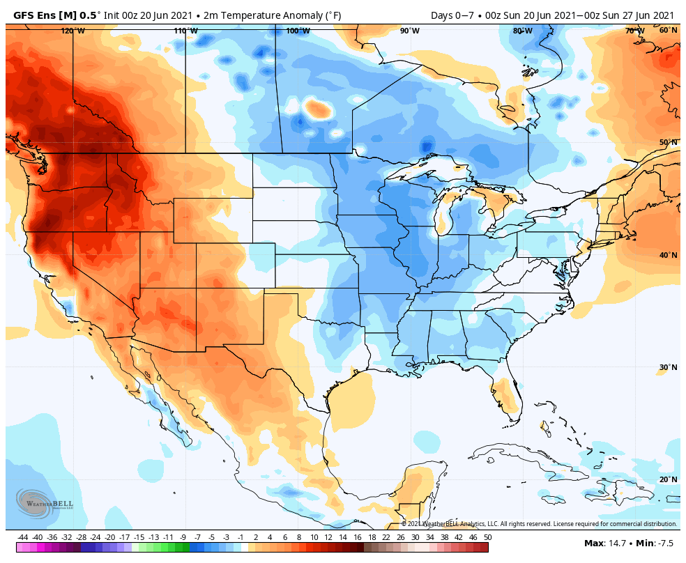
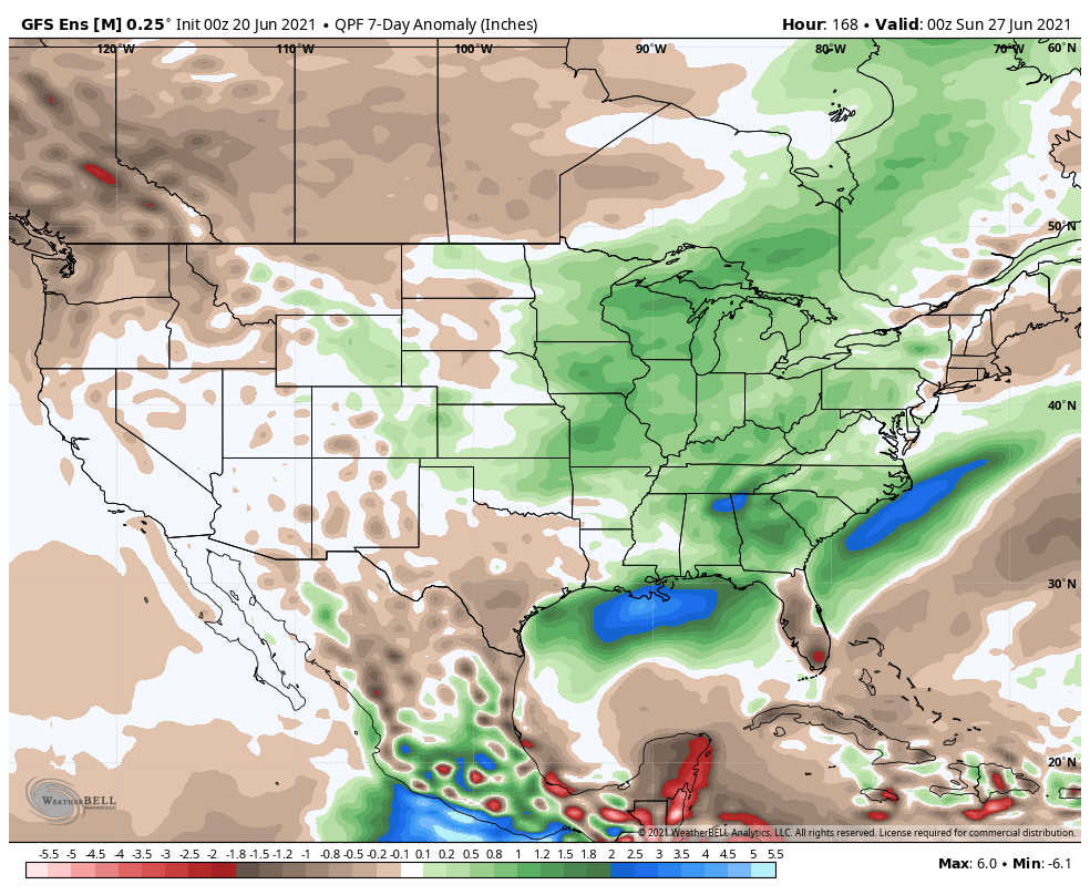
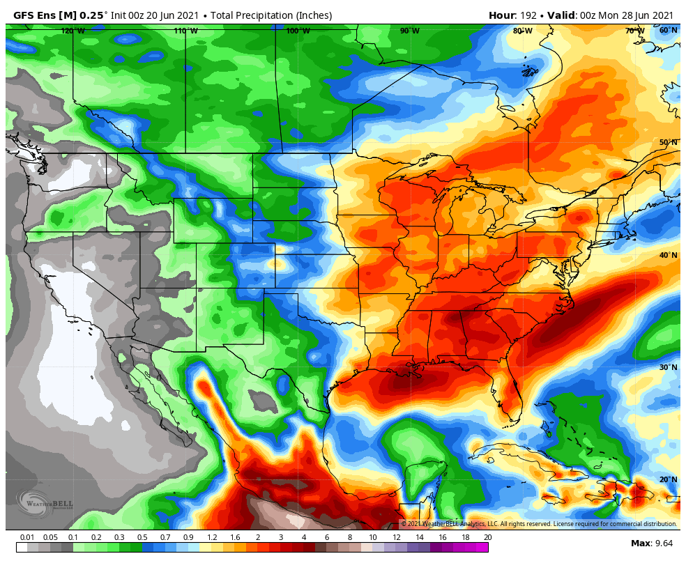
While we’re looking at an overall wetter than normal forecast period, there will be a multi-day stretch (centered on mid week) where we’ll enjoy dry conditions. This forecast period will be highlighted by additional storm potential with a cold front passing through to open the 7-day window, followed by the potential of heavy rain and stronger storms to close things out Friday into the weekend. Tuesday through Thursday will feature unseasonably cool and pleasant conditions, including the chance of some outlying areas to fall into the upper 40s. Warmth (and humidity) will build as we approach the weekend along with storm chances. While it’s still several days out, let’s circle Friday for the chance of heavy rain and stronger storms.
Permanent link to this article: https://indywx.com/2021/06/20/weekly-agwx-and-severe-weather-outlook-35/
Jun 19
Updated 06.19.21 @ 12:11p
You must be logged in to view this content. Click Here to become a member of IndyWX.com for full access. Already a member of IndyWx.com All-Access? Log-in here.
Permanent link to this article: https://indywx.com/2021/06/19/video-tracking-additional-storms-and-looking-ahead-to-early-july/
Jun 19
Updated 06.19.21 @ 7:58a (We’ll have a full video discussion posted later this morning, but here are some headlines grabbing our focus into early July). I. Tropical, Soupy Airmass Remains…
You must be logged in to view this content. Click Here to become a member of IndyWX.com for full access. Already a member of IndyWx.com All-Access? Log-in here.
Permanent link to this article: https://indywx.com/2021/06/19/saturday-morning-rambles-changes-on-the-horizon-unseasonably-cool-open-to-july/
Jun 18
Updated 06.18.21 @ 5:37p
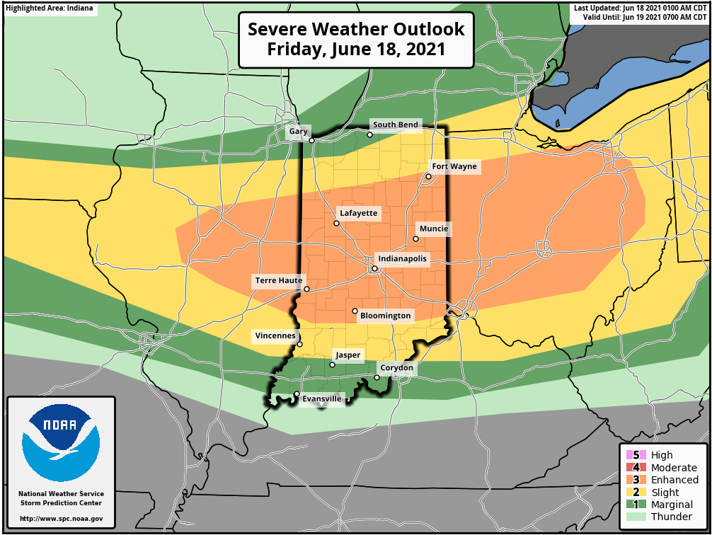
Type: Severe weather event

What: Severe weather event and flash flood threat
When: This afternoon through tonight
Severe Risks: Damaging wind, large hail, embedded tornado potential, flash flooding
Summary: A complex of thunderstorms to our north this morning will diminish. As a result, the cloud canopy engulfing much of the region this morning will give way to mostly sunny skies late morning and into the afternoon. Intense heat is expected this afternoon, courtesy of a southerly flow ahead of an approaching warm front and upper air disturbance. Highs will reach the lower to middle 90s this afternoon and heat indices will climb to between 100° and 105°. This heat, combined with a multitude of other ingredients: dew points into the 70s, convective available potential energy (CAPE) in excess of 4000 j/kg (suggestive of extreme instability), and steep low level lapse rates (rate of temperature change with height) all will play into what looks like a significant setup for a severe weather outbreak later this afternoon and tonight.
Initially, individual cells are likely to erupt (targeting mid to late afternoon) along an OFB (outflow boundary) across n-central Indiana. Damaging wind and large hail are the biggest concerns with these cells, but a tornado threat is also on the table in this highly unstable environment. Eventually the scattered, intense cells should congeal into more of a widespread storm complex by evening and impact most of central and southern parts of the state. Precipitable water values will be in excess of 2” and promote a flash flood risk, especially if thunderstorms back-build and train over the same communities. Should this be the case, localized rainfall amounts of 3”-4” will be a good bet. As we progress into the overnight hours, the storm complex and associated flood risk will shift downstate.
Confidence: HighN

Permanent link to this article: https://indywx.com/2021/06/18/client-brief-severe-weather-event-and-flash-flood-potential/
Jun 17
Updated 06.17.21 @ 5:58a
You must be logged in to view this content. Click Here to become a member of IndyWX.com for full access. Already a member of IndyWx.com All-Access? Log-in here.
Permanent link to this article: https://indywx.com/2021/06/17/video-severe-and-localized-flood-threat-increases-friday-unseasonably-cool-by-midweek/
Jun 16
Updated 06.16.21 @ 7:30a
You must be logged in to view this content. Click Here to become a member of IndyWX.com for full access. Already a member of IndyWx.com All-Access? Log-in here.
Permanent link to this article: https://indywx.com/2021/06/16/video-strong-storm-potential-friday-tropics-and-looking-at-the-pattern-to-close-june/
Jun 15
Updated: 06.15.21 @ 7:57a
You must be logged in to view this content. Click Here to become a member of IndyWX.com for full access. Already a member of IndyWx.com All-Access? Log-in here.
Permanent link to this article: https://indywx.com/2021/06/15/video-model-differences-on-storm-potential-friday-tropical-trouble-aimed-at-the-central-gulf-coast-this-weekend/
Jun 14
Updated 06.14.21 @ 7:41a
You must be logged in to view this content. Click Here to become a member of IndyWX.com for full access. Already a member of IndyWx.com All-Access? Log-in here.
Permanent link to this article: https://indywx.com/2021/06/14/video-a-cooler-less-humid-week/