Updated 04.07.21 @ 8a
You must be logged in to view this content. Click Here to become a member of IndyWX.com for full access. Already a member of IndyWx.com All-Access? Log-in here.

Apr 07
Updated 04.07.21 @ 8a
You must be logged in to view this content. Click Here to become a member of IndyWX.com for full access. Already a member of IndyWx.com All-Access? Log-in here.
Permanent link to this article: https://indywx.com/video-weather-goes-downhill-as-we-close-the-week-and-head-into-the-weekend/
Apr 06
Updated 04.06.21 @ 5:50p
You must be logged in to view this content. Click Here to become a member of IndyWX.com for full access. Already a member of IndyWx.com All-Access? Log-in here.
Permanent link to this article: https://indywx.com/evening-client-video-turning-more-unsettled-much-cooler-weather-looms/
Apr 06
Updated 04.06.21 @ 7:30a
This evening’s Client video update will handle the short-term rain and storm chances.
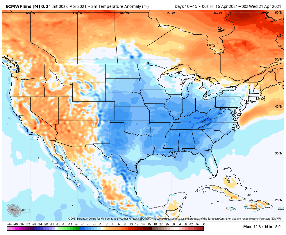
This morning, I wanted to review the upcoming shift towards a cooler period for mid-April.
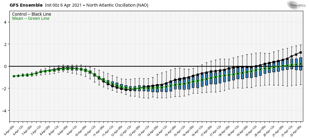
We have a couple of things that will drive this chillier stretch of weather, including a negative NAO:
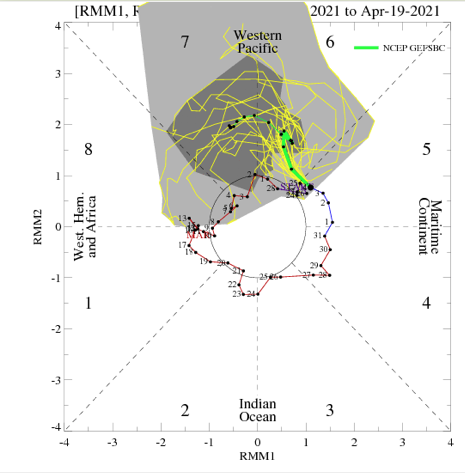
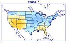
And a more amplified MJO moving out of the warm Phase 6 (now) into a much cooler Phase 7 for mid-month:

Note the period of blocking that develops as a byproduct of both:
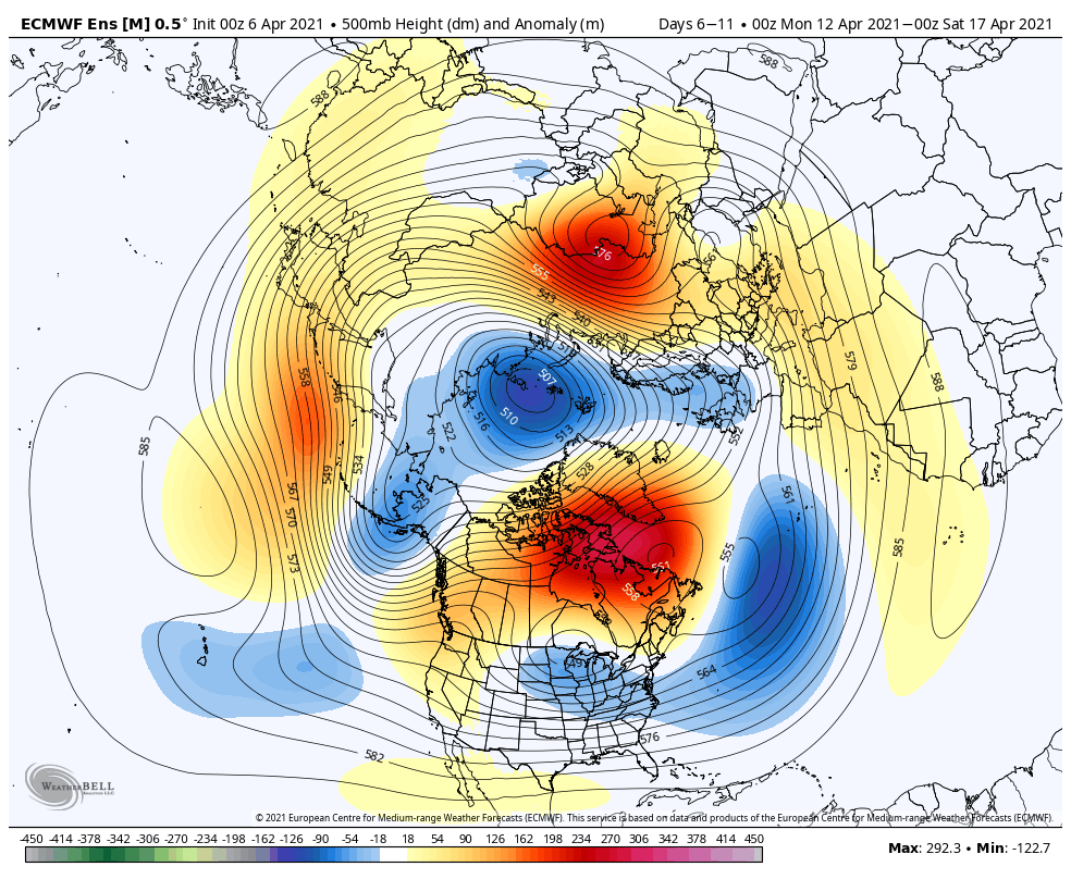
This will force the cooler changes underneath, including a 5 day stretch of temperatures that likely average 5° to 10° below normal around mid-month.
Don’t put away those jackets and sweatshirts just yet…
Permanent link to this article: https://indywx.com/warmth-is-fleeting-cooler-stretch-arrives-by-mid-april/
Apr 05
Updated 04.05.21 @ 7:32a
You must be logged in to view this content. Click Here to become a member of IndyWX.com for full access. Already a member of IndyWx.com All-Access? Log-in here.
Permanent link to this article: https://indywx.com/unseasonably-warm-rain-returns-by-midweek/
Apr 04
Updated 04.04.21 @ 8:38a
First and foremost, we want to wish you and your family a blessed Easter Sunday. Weather will be absolutely gorgeous, including sunny skies and highs that will top out in the lower 70s this afternoon! Enjoy!


Forecast period: 04.04.21 through 04.11.21
High pressure will dominate our weather to open the forecast period. This will result in a gorgeous Easter Sunday and extend into the early portion of the work week. We’ll notice humidity levels slowly climbing and a few more clouds will be around, but otherwise very nice conditions will prevail through most of the daytime Tuesday. Unseasonably warm conditions can be expected throughout the week ahead. Shower and thunderstorm chances will begin to increase Tuesday night and coverage will really ramp up through midweek. While the bulk of the severe weather is expected south of here, we’ll want to keep an eye on the potential of a couple stronger storms here Wednesday PM. The slow moving system should push east of here Friday evening, allowing high pressure to build back in as we open up next weekend.
Permanent link to this article: https://indywx.com/weekly-agwx-and-severe-weather-outlook-26/