February 2021 archive

Client Brief: Periods Of Blizzard Conditions Tonight…

Updated 02.15.21 @ 1:18p

Type: Severe Winter Weather
What: Heavy snow & strong winds

When: Through Tuesday morning

Temperatures: Mid 10s, falling into the upper single digits by Tuesday morning

Wind: NE 15 – 25 MPH (gusts up to 35 MPH Monday evening)

Blowing/ Drifting: Severe  

Pavement Impacts: Plowing and salting will be required

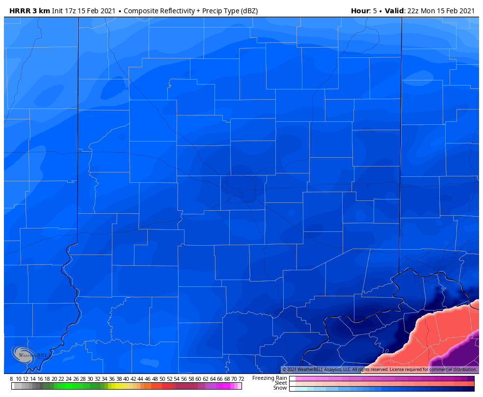
Summary: A shield of snow will encompass all of central Indiana through the afternoon and into the late evening hours. Snow will become heavy at times by mid and late afternoon, continuing through the evening hours, including snowfall rates of 1″ to 2″ per hour. As the area of low pressure draws closer this evening, northeast winds will strengthen and gust up to 35 MPH. Periods of whiteout conditions can be expected around, or just after sunset. Falling snow will end from south to north by midnight to 2a. Strong and gusty northerly winds will continue into Tuesday morning leading to severe blowing and drifting, especially in the open country. In these areas, drifts of 3 to 4 feet are expected.
Confidence: High

Next Update: This afternoon (video)

Permanent link to this article: https://indywx.com/2021/02/15/client-brief-periods-of-blizzard-conditions-tonight/

02.15.21 Weather Bulletin: Hunker Down…

Updated 02.15.21 @ 7:20a

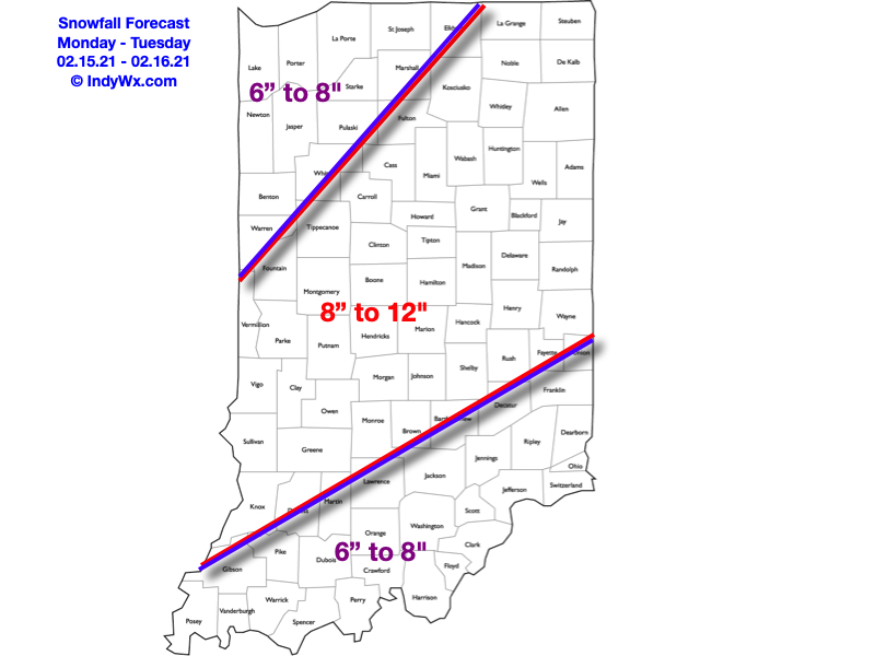
Be At Your Destination By Early Afternoon…Light snow continues to fall across the region this morning, but conditions will deteriorate rapidly as we move just beyond the lunchtime hour. Snowfall will become heavy and accumulate to the tune of 1″ to 2″ per hour this afternoon and tonight. By Tuesday morning, we expect many central Indiana communities to be closing in on a foot, and drifts in the open country will exceed 3 feet in spots. We highly discourage travel today if at all possible. If you have to travel this afternoon and evening, please ensure you have a winter storm survival kit packed as many roadways will become impassable due to a combination of very heavy snow and increasing wind. Speaking of wind, northeasterly gusts will top 35 MPH this evening, leading to severe drifting. Our snowfall forecast remains unchanged from yesterday.

Clean up from storm 1 should begin Tuesday morning as another winter storm has eyes on the region Wednesday night through Thursday. Despite a few lingering light snow showers Tuesday morning, a period of quieter conditions will develop for about 24 hours from Tuesday afternoon into Wednesday afternoon. Though it’ll still be much colder than normal, sunshine will return.

Our next storm system will come roaring out of the northwest Gulf Wednesday night, tracking northeast, up along the western slope of the Appalachians Thursday into Thursday night. You know the drill: this is a favorable track for another heavy snow storm and we expect adding several more inches onto our growing snowpack during this time frame. Stay tuned as we issue our snowfall forecast for Storm #2 later today.

Looking further ahead, it finally looks like we’ll climb out of the deep freeze by the 2nd half of the weekend. The problem? Another storm system will be approaching with snow and/ or a wintry mix.

Permanent link to this article: https://indywx.com/2021/02/15/02-15-21-weather-bulletin-hunker-down/

VIDEO: Roadways Become Impassable Tomorrow Evening From Combo Of Heavy Snow/ Severe Drifting; ANOTHER Strong Winter Storm Inbound Midweek…

Updated 02.14.21 @ 10p

You must be logged in to view this content. Click Here to become a member of IndyWX.com for full access.  Already a member of IndyWx.com All-Access?  Log-in here.

Permanent link to this article: https://indywx.com/2021/02/14/video-roadways-become-impassable-tomorrow-evening-from-combo-of-heavy-snow-severe-drifting-another-strong-winter-storm-inbound-midweek/

Client Brief: Snow Builds In Overnight; Becomes Heavy Monday Afternoon Into Monday Night…

Updated 02.14.21 @ 12:29p

Type: Severe Wintry Weather

What: Heavy snow & strong winds

When: Monday morning – Tuesday morning

Temperatures: 16° to 21°

Wind: NE 15 – 25 MPH (gusts up to 35 MPH Monday evening)

Blowing/ Drifting: Severe  

Pavement Impacts: Plowing and salting will be required

Summary: Light snow will overspread central Indiana during the overnight, continuing through Monday morning. As the surface low moves northeast (up the Appalachian chain), snowfall rates will increase Monday afternoon into Monday night, becoming heavy at times. The cold nature of this storm system will lead to an efficient snow producer, including rates that will likely top 1″ per hour at times Monday afternoon into Monday evening. As the low moves closer, the pressure gradient will tighten and lead to strengthening northeast wind gusts (up to 35 MPH) for a period of time after sunset into the late evening hours. Travel is highly discouraged tomorrow, especially by afternoon and evening as the combination of heavy snow and strong winds will likely lead to some roadways becoming impassable. Drifts in the open country will likely reach 3 to 4 feet by Tuesday morning. Snow will end from southwest to northeast Tuesday morning.

*Our other products issued later tonight will handle the expected additional significant impacts with Storm #2.

Confidence: High

Next Update: Tonight (video)

Permanent link to this article: https://indywx.com/2021/02/14/client-brief-snow-builds-in-overnight-becomes-heavy-monday-afternoon-into-monday-night/

02.14.21 Weather Bulletin: Memorable Week Of Winter Weather…

Updated 02.14.21 @ 8a

Back-to-Back Heavy Snow Storms…Use today to complete preparations for what will be a memorable week of winter weather. While bitter out this morning, we’ll at least enjoy a dry day. Wind chills that are at dangerous levels right now (-10° to -20°) will “warm” to between 0° and 5° above this afternoon.

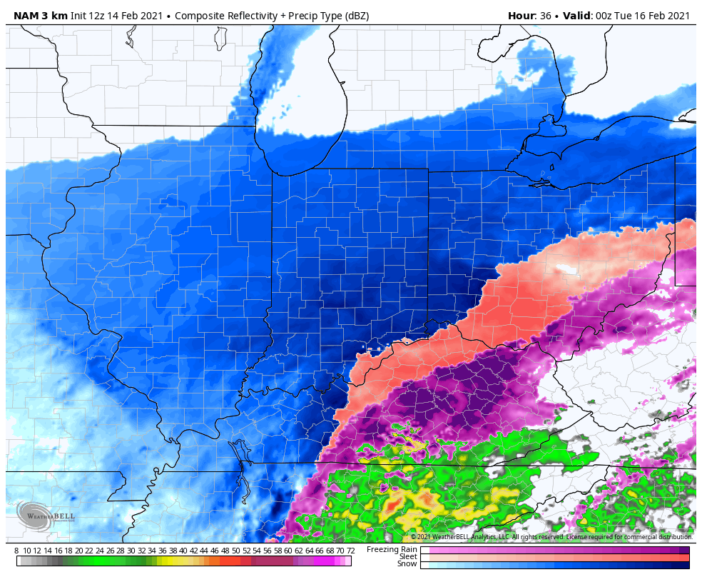
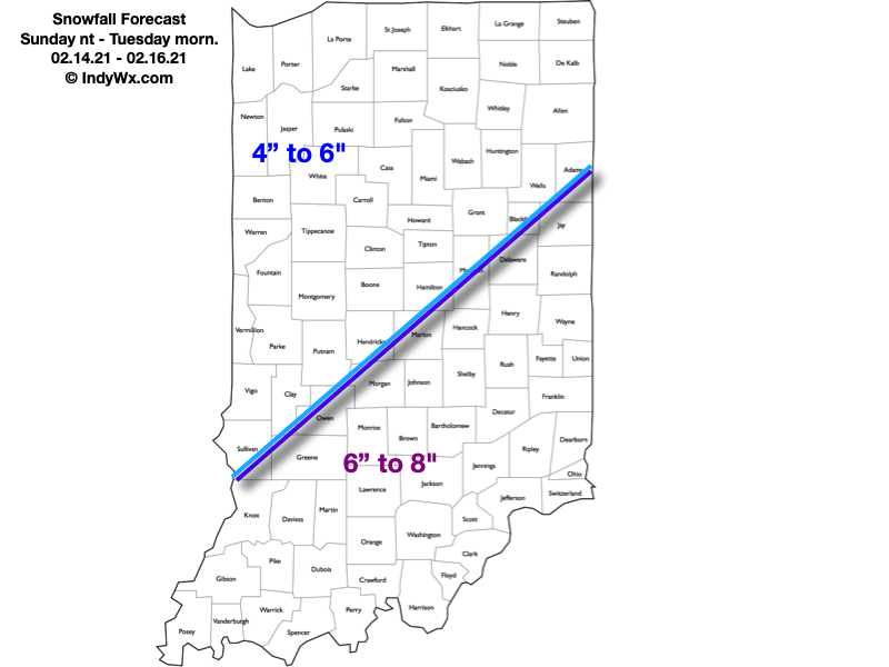
Snow will overspread the state from southwest to northeast as we move through the night. Initially, we’re talking about mostly light snow, but roadways will be a mess for the morning commute Monday (given how cold it’s been as of late). If you can avoid travel altogether, we’d recommend doing so. Snow will really begin to pick up in intensity after lunchtime Monday, and especially towards evening, continuing into the overnight hours. Periods of heavy snow can be expected during this time frame. The snow will be mostly out of here by Tuesday morning, but not before depositing a widespread 5″ to 8″, including localized amounts up to 10″. You’ll want to get on the clean up from the first storm as another “big one” awaits.

After a mostly dry Tuesday and daytime Wednesday, light snow will develop towards sunset and become heavy at times Thursday. This second storm has the potential to be equally, if not more, significant than its predecessor and we’ll have early snowfall numbers issued this afternoon. By Friday morning, widespread snowfall totals of 10″ to 15″ (if not more in spots) can be expected with drifts in the open country that even a yardstick won’t be able to handle.

We’ll have our updated snowfall maps included with our Client video update that will be published this afternoon. A Client Brief will be posted later today, as well, focusing on the specific details of Storm #1.

Permanent link to this article: https://indywx.com/2021/02/14/02-14-21-weather-bulletin-memorable-week-of-winter-weather/

VIDEO: Memorable Week Ahead For #INwx Winter Weather Lovers…

Updated 02.13.21 @ 2:31p

You must be logged in to view this content. Click Here to become a member of IndyWX.com for full access.  Already a member of IndyWx.com All-Access?  Log-in here.

Permanent link to this article: https://indywx.com/2021/02/13/video-memorable-week-ahead-for-inwx-winter-weather-lovers/

02.13.21 Weather Bulletin: Snowfall Forecast Issued; Initial HVY Snow Zone Idea For Midweek…

Updated 02.13.21 @ 9:56a

Back-to-Back Winter Storms…A weak trough of low pressure extends south into the northern portion of Indiana this morning. This will serve to help enhance snow “up north” through the day- including a little lake enhancement this evening. Scattered snow showers will work into central Indiana later this afternoon into the evening, but shouldn’t be a big deal.

Bitterly cold air will greet us out the door Sunday morning, but this will be the proverbial calm before the storm. A mix of clouds and sun will give way to an increasingly cloudy sky during the evening hours and snow will break out from southwest to northeast late Sunday evening into the overnight and predawn Monday. This is the “1st wave” of the early week storm. A lull in the snow is possible late Monday morning into the early afternoon before the real show begins Monday evening into the predawn hours Tuesday across southeast Indiana. This will be a very cold storm and snowfall ratios will be much higher than standard 10:1 (closer to 15-20:1) which means this should be an efficient snow producer across the region. The dry, powdery nature of the snow will blow about quite easily and snow removal clients should prepare for an extended period of significant blowing and drifting issues through the upcoming week (even well after the falling snow stops).

Here’s our first stab at accumulation with Storm #1. We’ll refine these numbers if need be moving forward.

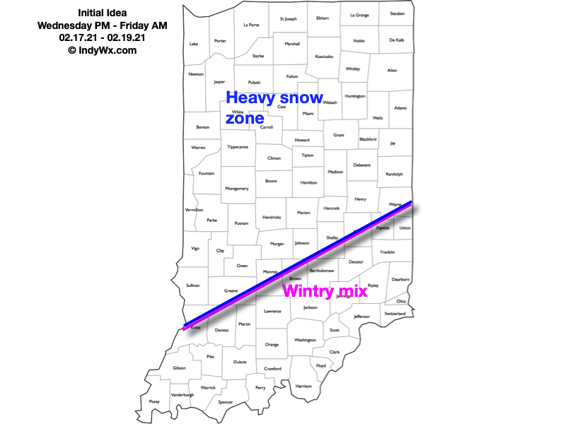
Morning snow will end from west to east Tuesday morning and we’ll have about 24 hours of relative calm before additional fun and games roll into town Wednesday night. While still early, there seems to be potential for Storm #2 to be more significant across a larger chunk of the state. We’re noticing the majority of forecast models starting to “bulk up” on precipitation amounts with this storm and the negative PNA will likely continue to force the storm ever so much further west with time. The potential is even present for more mixing issues as warmer air aloft is drawn in across southeast Indiana. Where things remain mostly (if not all) snow, a big hit is likely Wednesday evening into Friday morning. Let’s get through the day tomorrow before getting specific with totals, but here’s our initial idea.

Permanent link to this article: https://indywx.com/2021/02/13/02-13-21-weather-bulletin-snowfall-forecast-issued-initial-hvy-snow-zone-idea-for-midweek/

VIDEO: Use The Weekend To Prepare…

Updated 02.12.21 @ 5:50p

You must be logged in to view this content. Click Here to become a member of IndyWX.com for full access.  Already a member of IndyWx.com All-Access?  Log-in here.

Permanent link to this article: https://indywx.com/2021/02/12/video-use-the-weekend-to-prepare/

02.12.21 Weather Bulletin: Continuing To Keep Close Eyes On Next Week…

Updated: 02.12.21 @ 7:34a

Use This Weekend To Prep…The short-term portion of this forecast is relatively quiet. Take advantage and prepare for significant winter weather next week. We may even see a few breaks in the cloud cover today. All in all, look for mostly cloudy and continued cold conditions. Keep in mind, average highs this time of year should be close to 40°. We’ll be nowhere near that anytime soon. In fact, most days will feature high temperatures even colder than average lows for this time of year!

Reinforcing arctic air will penetrate the area Saturday and will likely kick up some light snow showers- especially during the afternoon. Light snow will remain a possibility Valentine’s Day, but “light” is the key word.

The more exciting part of this forecast comes at us as we open the work week. Surface low pressure will develop in the northwest Gulf of Mexico Sunday night and track northeast up along the Appalachians. This will spread a swath of snow into the Ohio Valley through the day Monday. It appears as if snow will become heavy at times Monday evening into the predawn hours Tuesday before tapering to light snow/ snow showers late Tuesday morning. This will be a much more powdery snow than we typically see with these Gulf storms, due to having truly arctic air involved with the storm. Gusty winds will create significant blowing and drifting issues throughout the early and middle portion of the work week.

That then leads us to the threat of another significant winter storm as we push into Wednesday night into Friday morning. We don’t want to get ahead of ourselves, but the threat is very real that this storm also deals out heavy impacts across the region with additional heavy snow possible during the aforementioned time frame.

We’d suggest using the weekend to prepare for the potential of two back-to-back “big deal” winter storms. We’ll be here through the weekend with additional updates.

Averages: H: 39/ L: 23° on the 12th –> H: 41°/ L: 25° on the 18th

Permanent link to this article: https://indywx.com/2021/02/12/02-12-21-weather-bulletin-continuing-to-keep-close-eyes-on-next-week/

VIDEO: Long Range Update And Fresh Thoughts On Next Week…

Updated 02.11.21 @ 10:48p I apologize for the abrupt stop in tonight’s video. After rambling on for close to 20 min., YouTube informed me that I had to trim under…

You must be logged in to view this content. Click Here to become a member of IndyWX.com for full access.  Already a member of IndyWx.com All-Access?  Log-in here.

Permanent link to this article: https://indywx.com/2021/02/11/video-long-range-update-and-fresh-thoughts-on-next-week/

IndyWx.com