Updated 02.14.21 @ 10p
You must be logged in to view this content. Click Here to become a member of IndyWX.com for full access. Already a member of IndyWx.com All-Access? Log-in here.

Feb 14
Updated 02.14.21 @ 10p
You must be logged in to view this content. Click Here to become a member of IndyWX.com for full access. Already a member of IndyWx.com All-Access? Log-in here.
Permanent link to this article: https://indywx.com/2021/02/14/video-roadways-become-impassable-tomorrow-evening-from-combo-of-heavy-snow-severe-drifting-another-strong-winter-storm-inbound-midweek/
Feb 14
Updated 02.14.21 @ 12:29p
Type: Severe Wintry Weather

What: Heavy snow & strong winds
When: Monday morning – Tuesday morning
Temperatures: 16° to 21°
Wind: NE 15 – 25 MPH (gusts up to 35 MPH Monday evening)
Blowing/ Drifting: Severe
Pavement Impacts: Plowing and salting will be required
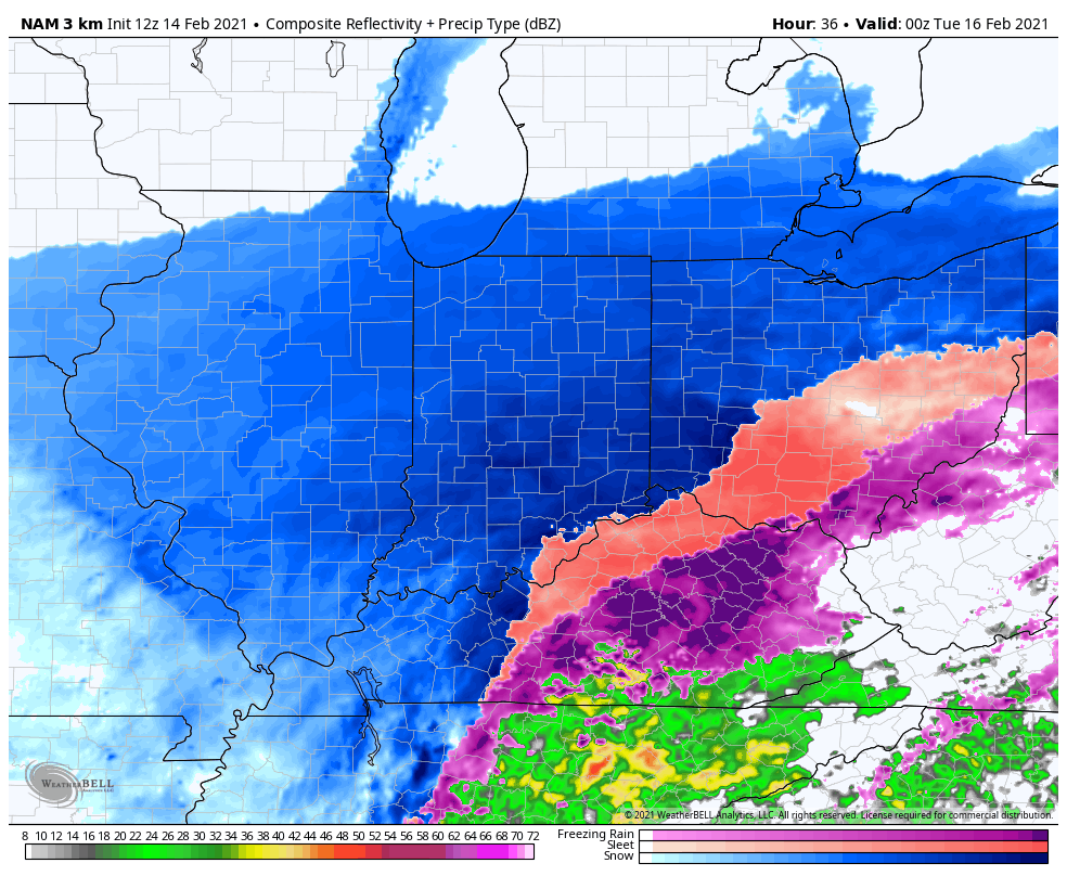
Summary: Light snow will overspread central Indiana during the overnight, continuing through Monday morning. As the surface low moves northeast (up the Appalachian chain), snowfall rates will increase Monday afternoon into Monday night, becoming heavy at times. The cold nature of this storm system will lead to an efficient snow producer, including rates that will likely top 1″ per hour at times Monday afternoon into Monday evening. As the low moves closer, the pressure gradient will tighten and lead to strengthening northeast wind gusts (up to 35 MPH) for a period of time after sunset into the late evening hours. Travel is highly discouraged tomorrow, especially by afternoon and evening as the combination of heavy snow and strong winds will likely lead to some roadways becoming impassable. Drifts in the open country will likely reach 3 to 4 feet by Tuesday morning. Snow will end from southwest to northeast Tuesday morning.
*Our other products issued later tonight will handle the expected additional significant impacts with Storm #2.

Confidence: High
Next Update: Tonight (video)
Permanent link to this article: https://indywx.com/2021/02/14/client-brief-snow-builds-in-overnight-becomes-heavy-monday-afternoon-into-monday-night/
Feb 14
Updated 02.14.21 @ 8a

Back-to-Back Heavy Snow Storms…Use today to complete preparations for what will be a memorable week of winter weather. While bitter out this morning, we’ll at least enjoy a dry day. Wind chills that are at dangerous levels right now (-10° to -20°) will “warm” to between 0° and 5° above this afternoon.
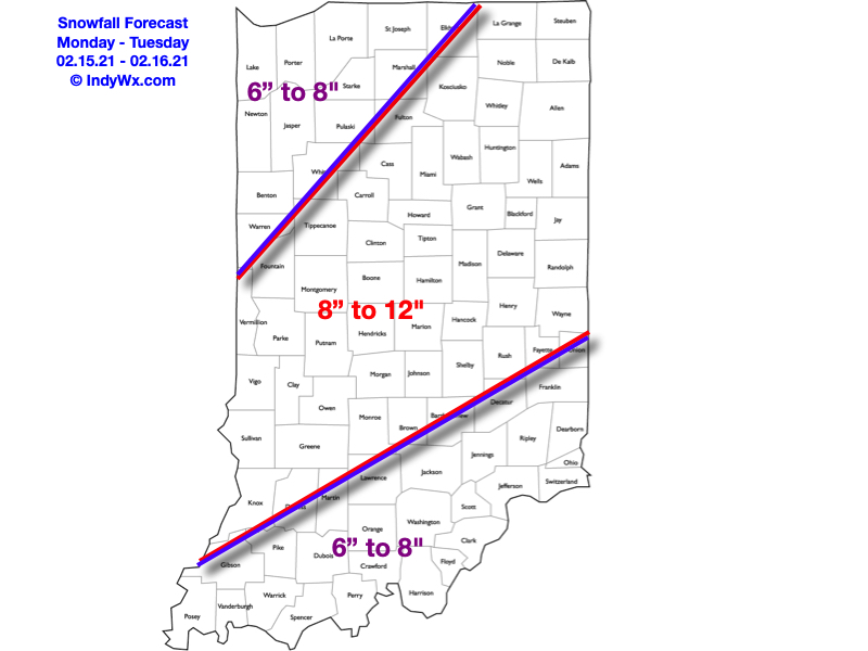
Snow will overspread the state from southwest to northeast as we move through the night. Initially, we’re talking about mostly light snow, but roadways will be a mess for the morning commute Monday (given how cold it’s been as of late). If you can avoid travel altogether, we’d recommend doing so. Snow will really begin to pick up in intensity after lunchtime Monday, and especially towards evening, continuing into the overnight hours. Periods of heavy snow can be expected during this time frame. The snow will be mostly out of here by Tuesday morning, but not before depositing a widespread 5″ to 8″, including localized amounts up to 10″. You’ll want to get on the clean up from the first storm as another “big one” awaits.
After a mostly dry Tuesday and daytime Wednesday, light snow will develop towards sunset and become heavy at times Thursday. This second storm has the potential to be equally, if not more, significant than its predecessor and we’ll have early snowfall numbers issued this afternoon. By Friday morning, widespread snowfall totals of 10″ to 15″ (if not more in spots) can be expected with drifts in the open country that even a yardstick won’t be able to handle.
We’ll have our updated snowfall maps included with our Client video update that will be published this afternoon. A Client Brief will be posted later today, as well, focusing on the specific details of Storm #1.
Permanent link to this article: https://indywx.com/2021/02/14/02-14-21-weather-bulletin-memorable-week-of-winter-weather/