July 2020 archive

VIDEO: Looking Ahead Into Mid-Late Next Week; Reviewing NEW JMA Weeklies Into August…

You must be logged in to view this content. Click Here to become a member of IndyWX.com for full access.  Already a member of IndyWx.com All-Access?  Log-in here.

Permanent link to this article: https://indywx.com/2020/07/16/video-looking-ahead-into-mid-late-next-week-reviewing-new-jma-weeklies-into-august/

Evening Update On Severe Weather Currently To Our West…

You must be logged in to view this content. Click Here to become a member of IndyWX.com for full access.  Already a member of IndyWx.com All-Access?  Log-in here.

Permanent link to this article: https://indywx.com/2020/07/15/evening-update-on-severe-weather-currently-to-our-west/

VIDEO: Detailed Look At Storm Chances Tonight And A Wet Close To The Month…

You must be logged in to view this content. Click Here to become a member of IndyWX.com for full access.  Already a member of IndyWx.com All-Access?  Log-in here.

Permanent link to this article: https://indywx.com/2020/07/15/video-detailed-look-at-storm-chances-tonight-and-a-wet-close-to-the-month/

Strong-Severe Storm Potential Late Tomorrow Night Into Predawn Thursday…

High pressure will supply another fantastic day of weather including plentiful sunshine. Humidity levels will remain low today as highs top out in the upper 80s (in case you’re wondering, the average high for July 14th is 85°). Most of our Wednesday will also be nice, but that begins to change Wednesday night…

The Storm Prediction Center includes central Indiana in a ‘marginal’ risk of severe weather both Wednesday and Thursday. This is to account for the potential of a strong-to-severe complex of thunderstorms moving across the state during the overnight period.

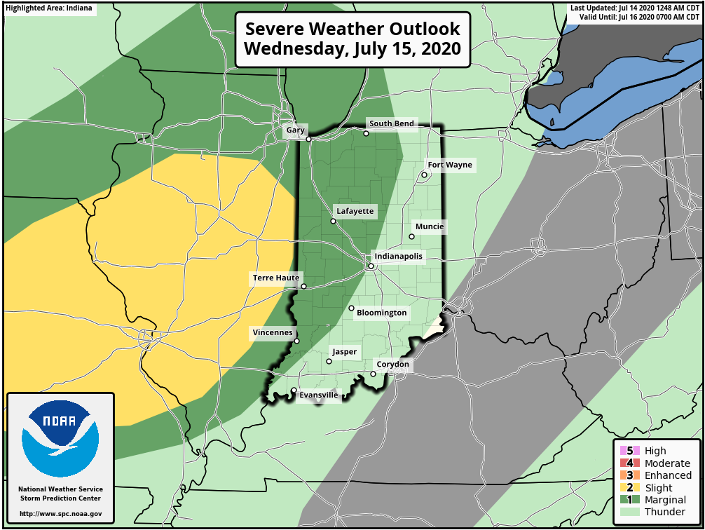
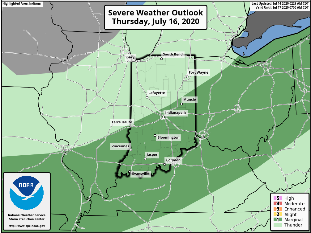
This is all thanks to an approaching low pressure system and associated frontal boundary. Eventually, the low pressure system will “wash out” but the boundary will linger in the vicinity, keeping the threat of strong to severe storms across southern and southeastern Indiana during the daytime Thursday.

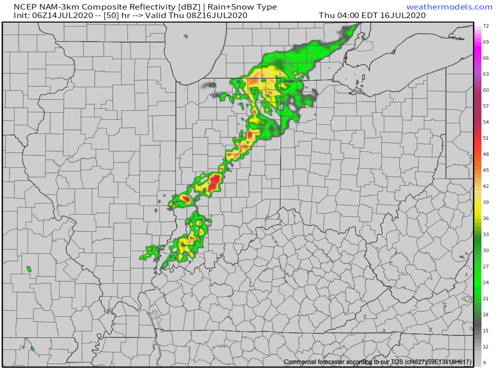
The vast majority of central Indiana will likely have to deal with thunderstorms late Wednesday night into the predawn Thursday. Given the ingredients in place (50 knot low level jet and dew points that should be approaching 70°) Wednesday night, embedded strong-to-severe thunderstorms are expected. The biggest concerns will be damaging straight line wind potential with these storms.

Forecast radar 4a Thursday.

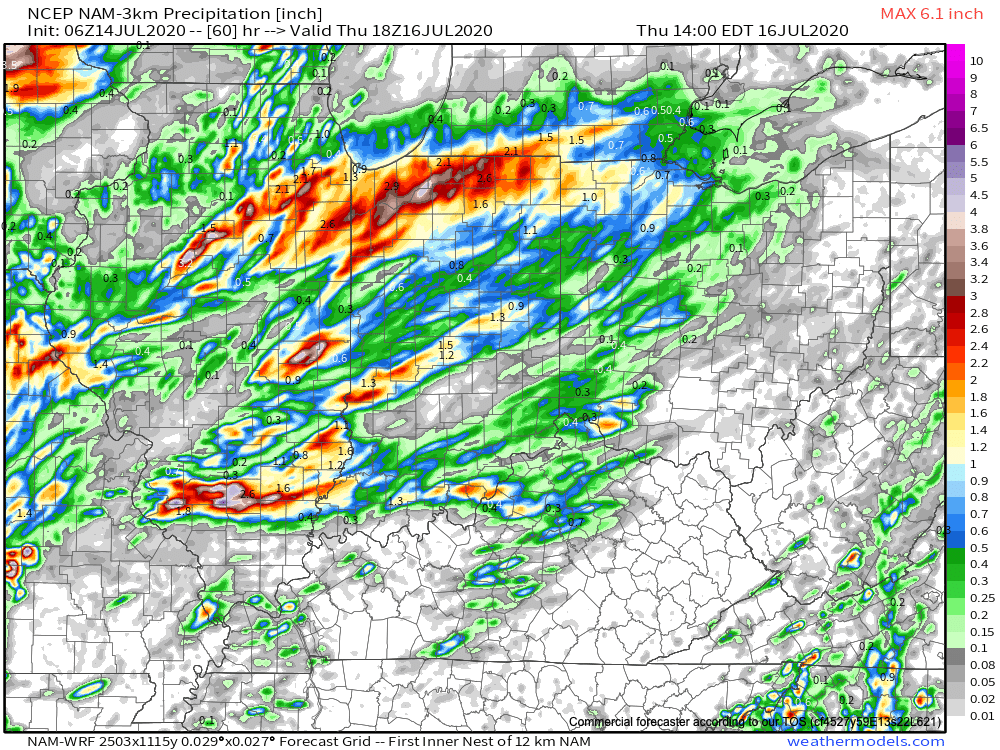
Locally heavy rain will also be likely as moisture levels rise overnight into Thursday. A quick 1″ of rain can be expected for most of central Indiana with locally heavier amounts where the stronger storms track.

We’ll have more on this and the pattern ahead with our evening video update a bit later. Make it a great Tuesday!

Permanent link to this article: https://indywx.com/2020/07/14/strong-severe-storm-potential-late-tomorrow-night-into-predawn-thursday/

VIDEO: Timing Out Storm Threats This Week And Reviewing The Pattern To Close July…

You must be logged in to view this content. Click Here to become a member of IndyWX.com for full access.  Already a member of IndyWx.com All-Access?  Log-in here.

Permanent link to this article: https://indywx.com/2020/07/13/video-timing-out-storm-threats-this-week-and-reviewing-the-pattern-to-close-july/

Weekly #AGwx And #Severe Weather Outlook…

I. Heat and humidity builds as we move through the 2nd half of the week.

II. Pattern once again turns active and unsettled mid and late week.

Seasonable temperatures will rise to slightly above normal levels once to mid week, continuing into the weekend. As a whole, the period will run slightly above normal for central Indiana.
The 7-day period should feature above normal rainfall for central Indiana.
We forecast a total of 1″ to 2″ of rain for central Indiana between now and next Sunday with locally heavier totals.

Though the Storm Prediction Center doesn’t currently have a Day 4 severe weather risk highlighted, we need to keep close eyes on this feature for the potential of strong to severe thunderstorms late Wednesday. Large hail and damaging winds are of greatest concern.

Forecast Period: 07.12.20 through 07.19.20

Additional scattered showers and thunderstorms will fire today but shouldn’t be nearly as intense or widespread as what last night delivered. We’ll then welcome a couple of days of cooler, less humid air with dry conditions. Enjoy as the heat, humidity, and storms will return by midweek. In fact, as mentioned above, the potential is present for some stronger storms late Wednesday and it wouldn’t surprise us if the Storm Prediction Center includes portions of the region in a severe weather risk over the next day or two for this threat. This will come on the leading edge of hotter and more humid weather for the 2nd half of the week, continuing into next weekend. As we look longer range (Week 2 time frame), the upper level ridge is expected to retrograde west and open us up to a northwesterly flow aloft. There are strong signals this will lead to a rather busy time of things as we wrap up July, including above to well above average rainfall. Before this takes place, we’re likely looking at another 6-7 day stretch of highs in the lower 90s.

Permanent link to this article: https://indywx.com/2020/07/12/weekly-agwx-and-severe-weather-outlook-13/

VIDEO: Gusty Storms Impact Parts Of The Area Tonight; Pattern Turns Active To Close July…

You must be logged in to view this content. Click Here to become a member of IndyWX.com for full access.  Already a member of IndyWx.com All-Access?  Log-in here.

Permanent link to this article: https://indywx.com/2020/07/11/video-gusty-storms-impact-parts-of-the-area-tonight-pattern-turns-active-to-close-july/

VIDEO: Subtle Differences In The ‘Mean’ Ridge Position Makes All The Difference…

You must be logged in to view this content. Click Here to become a member of IndyWX.com for full access.  Already a member of IndyWx.com All-Access?  Log-in here.

Permanent link to this article: https://indywx.com/2020/07/10/video-subtle-differences-in-the-mean-ridge-position-makes-all-the-difference/

Long Range Update Into Early August…

You must be logged in to view this content. Click Here to become a member of IndyWX.com for full access.  Already a member of IndyWx.com All-Access?  Log-in here.

Permanent link to this article: https://indywx.com/2020/07/09/long-range-update-into-early-august/

VIDEO: Weekend Break From The Heat Before Even Hotter Conditions Build In Next Week…

You must be logged in to view this content. Click Here to become a member of IndyWX.com for full access.  Already a member of IndyWx.com All-Access?  Log-in here.

Permanent link to this article: https://indywx.com/2020/07/09/video-weekend-break-from-the-heat-before-even-hotter-conditions-build-in-next-week/

IndyWx.com