February 2020 archive

March 2020 Outlook…

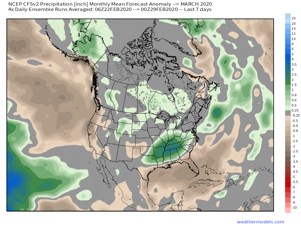
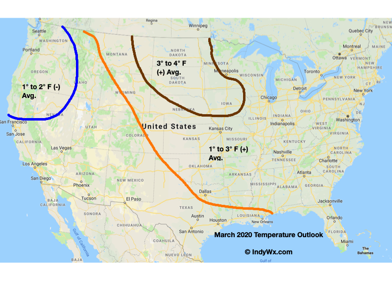
The majority of longer range models are bullish on a much warmer than normal month of March. Below you’ll see a snap shot of the latest JMA Weeklies, European Weeklies, and CFSv2. All are in relative agreement on a warm open to meteorological spring.

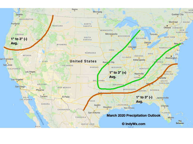
The other common theme? Strong signals for wetter, to much wetter, than normal conditions.
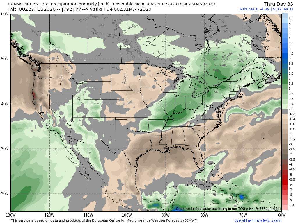
Note the first image of the JMA Weekly data is also leaning in the direction of wetter than normal conditions.

Indianapolis March “averages” include a low of 32.8°, a high of 51.7°, 3.56″ of rain, and 2.6″ of snow.

We’re leaning in the direction of a warmer than normal, wetter than normal month, as well. The reason? You guessed it- a predominantly positive EPO and the MJO that’s expected to rumble primarily through the warmer phases for this time of year.

We’ll tackle the latter first. Note the latest MJO plot takes things through Phases 4-5. Those are notorious warm phases in March as shown by the composite 500mb analogs below.
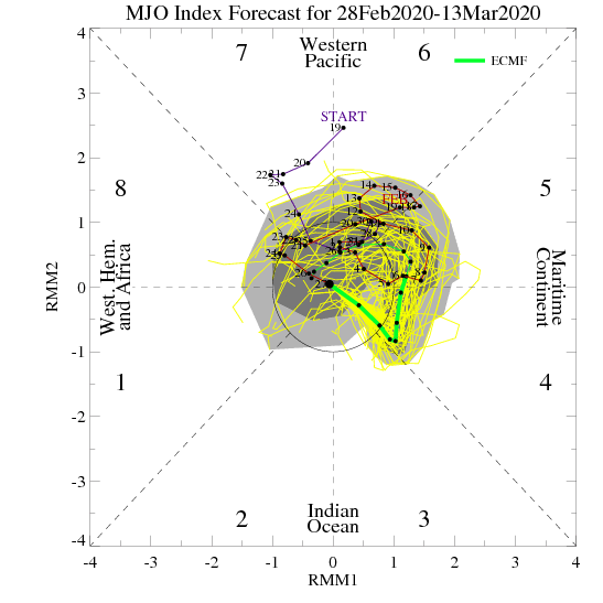
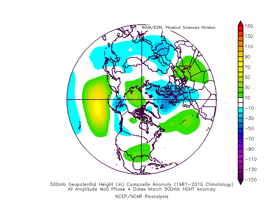
While the MJO plot above only goes out to mid-month, there are reasons to believe things won’t get into the cold phases and that we should cycle back into the warmer phases, or potentially remain in the “null” phase.

We’ll, of course, have to monitor the EPO for negative “jabs” that may try and take place, but think we’re looking at a predominantly positive EPO throughout the month. Additionally, the NAO (North Atlantic Oscillation) looks to also remain predominantly positive and this is also a warm signal for this time of year.

Accordingly, we’re leaning towards a warm, yet wet open to meteorological spring, including temperatures that should run 1° to 3° above normal across central Indiana.
Permanent link to this article: https://indywx.com/2020/02/29/march-2020-outlook/

VIDEO: Snow Returns This Afternoon; Looking Ahead To The 1st Half Of March…

You must be logged in to view this content. Click Here to become a member of IndyWX.com for full access.  Already a member of IndyWx.com All-Access?  Log-in here.

Permanent link to this article: https://indywx.com/2020/02/28/video-snow-returns-this-afternoon-looking-ahead-to-the-1st-half-of-march/

VIDEO: Additional Scattered Snow Showers/ Squalls Today Into Friday AM; Active Pattern Next Week…

An active weather pattern will remain in place. Not only will we have to watch for scattered snow squalls this evening (snow will be heavy enough to greatly reduce visibility…

You must be logged in to view this content. Click Here to become a member of IndyWX.com for full access.  Already a member of IndyWx.com All-Access?  Log-in here.

Permanent link to this article: https://indywx.com/2020/02/27/video-additional-scattered-snow-showers-squalls-today-into-friday-am-active-pattern-next-week/

VIDEO: Snow Increases In Coverage/ Intensity Late Morning Into The Afternoon; Active Pattern Over The Upcoming 10 Days…

You must be logged in to view this content. Click Here to become a member of IndyWX.com for full access.  Already a member of IndyWx.com All-Access?  Log-in here.

Permanent link to this article: https://indywx.com/2020/02/26/video-snow-increases-in-coverage-intensity-late-morning-into-the-afternoon-active-pattern-over-the-upcoming-10-days/

Tuesday Evening Check-Up On Wednesday’s Snow Event…

During a month that’s running 2.5° above normal, many across central Indiana will be sitting at “average” snowfall once to Thursday morning (with the potential of some “bonus” snow for some Friday). Not too shabby, heh?! Let’s dig into some of the latest data. In short, our going forecast remains in good shape and now it’s time to watch the event unfold.

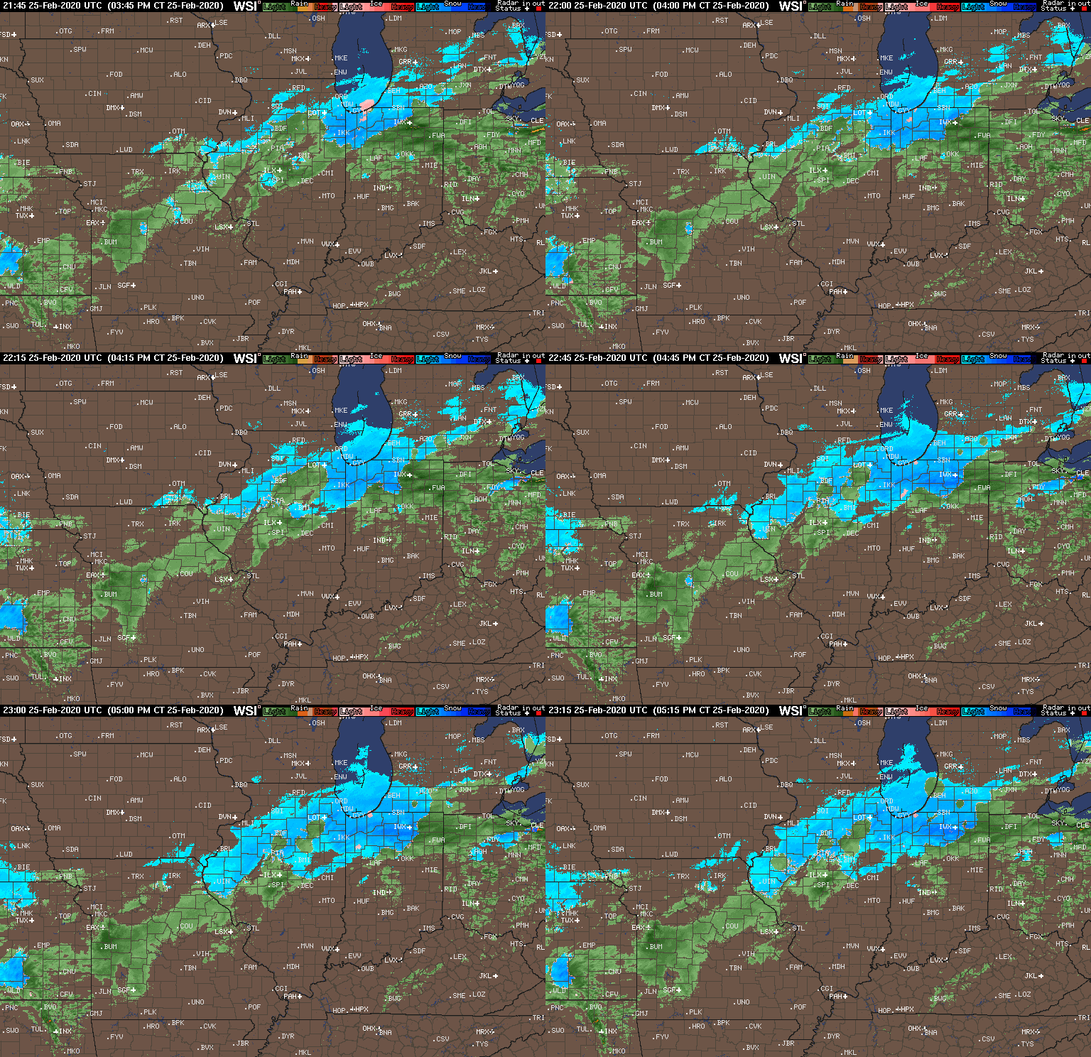
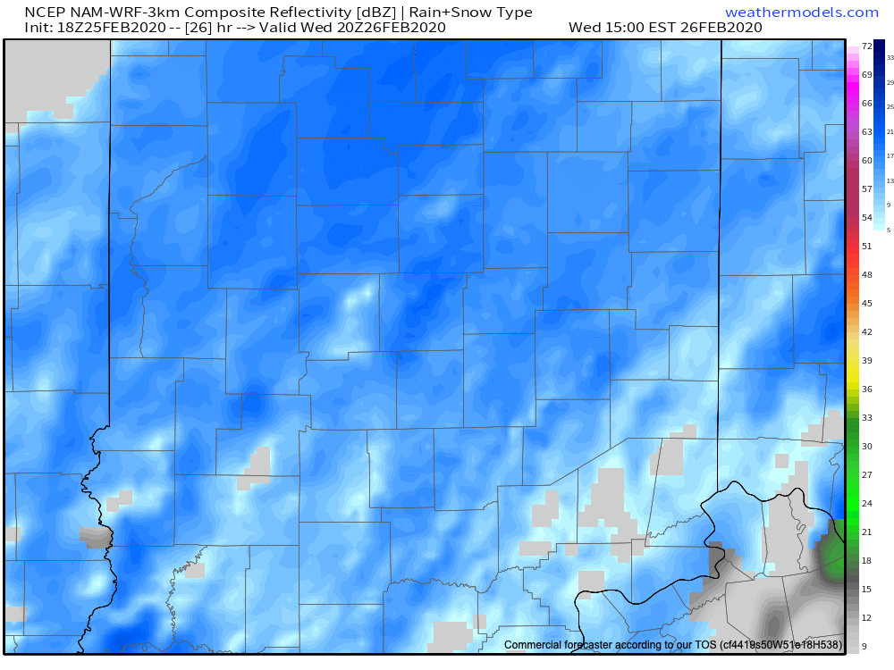
As we type this around 6:30p Tuesday evening, snow is increasing in intensity across northern Indiana and precipitation will continue to become more organized across IL throughout the evening. The bulk of central Indiana is only dealing with drizzle and light rain this evening. It’s a damp, chilly night, but there’s no threat to travel if you’re heading out to dinner or other events with the family.

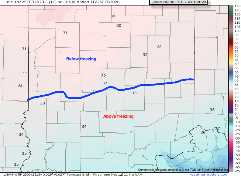
Colder air will continue to “ooze” into central Indiana throughout the night and as this takes place, a surface wave will develop south of the Ohio River. By 6a, the freezing line is expected to be just south of Indianapolis.

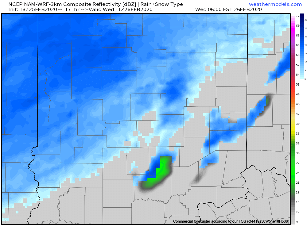
Light to moderate snow is expected to begin overspreading central Indiana in earnest around this time frame (earlier further north).

Snow will increase in overall intensity late morning into the afternoon hours (this is when we anticipate the greatest snowfall rates).

“System” snow will begin to diminish across central Indiana between 5p (west) and 7p (east), but we’ll have to monitor whether or not lake effect snow bands can make it as far south as portions of central Indiana tomorrow night as the wind flow backs around to the northwest and much colder air drives south.

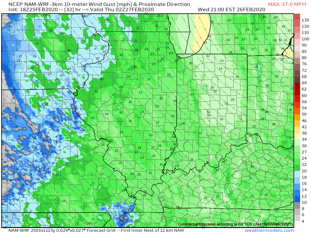
Speaking of wind, we still anticipate northwest winds to increase to 30 MPH+ Wednesday evening across the area. This will lead to considerable blowing and drifting tomorrow night of what should become an increasingly dry/ powdery snow towards the 2nd half of the event.

Things should quieten down through the day Thursday, but cold air (well below normal) will rule into the 1st half of the weekend. We continue to believe the coldest morning of the bunch will come Saturday with widespread middle 10s. Before that, and as mentioned above, we’ll have to monitor some additional snow prospects for some Friday (more on that in the AM :-))!

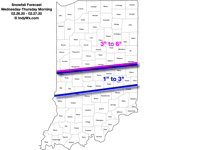
Until then, enjoy our midweek snow. Our ongoing snowfall forecast first issued last night remains in place.

Permanent link to this article: https://indywx.com/2020/02/25/tuesday-evening-check-up-on-wednesdays-snow-event/

VIDEO: Winter Storm Impacts Central Indiana Wednesday Into Thursday Morning…

You must be logged in to view this content. Click Here to become a member of IndyWX.com for full access.  Already a member of IndyWx.com All-Access?  Log-in here.

Permanent link to this article: https://indywx.com/2020/02/25/video-winter-storm-impacts-central-indiana-wednesday-into-thursday-morning/

Client Brief: Threat Of Impactful Wintry Event Increasing As Southeast Shift Continues…

Type: Impactful Wintry Weather

What: Accumulating snow and wind

When: Wednesday into Thursday morning

Temperatures: Middle 30s falling into the middle 20s by Wednesday night

Wind: North 15-25 MPH, increasing to 25-40 MPH Wednesday night and gusty

Blowing/ Drifting: Moderate to significant by Wednesday evening, continuing into Thursday morning

Pavement Impacts: Salting and plowing likely will be required

There has been a significant shift in the majority of model data today regarding the track of our midweek storm system. This has to do with a variety of elements, but most notably, the fact that the upper level energy at one time thought to come together to result in one primary storm during the first half of the work week, now looks to come in two parts: Monday into Tuesday, followed by a separate storm Wednesday into Thursday (this was what at one time was illustrated by the models a week+ ago). The debate now will continue for the next 24 hours around the deepening Storm #2 goes through, and this will have significant impacts on what central Indiana experiences in the Wednesday through Thursday time period. We think an initial wave of low pressure will organize along and just south of the Ohio River Tuesday night before tracking northeast and strengthening along the way into the eastern Great Lakes by Wednesday night. Should this, indeed, be the case, moisture would become widespread (after a relative “lull” Tuesday evening) across central Indiana Wednesday morning. With cold air funneling into the area by this time, the predominant precipitation type would fall as snow across central Indiana, including Indianapolis. Initially, this would be a wet type of snow before transitioning to a more powdery nature Wednesday evening.

As the storm begins to deepen to our northeast, blowing and drifting snow would become a concern on west-east roadways Wednesday evening into Wednesday night as the pressure gradient increases. By this time frame, north and eventually northwest winds would gust over 30 MPH with temperatures falling through the 20s. “System” snow would come to an end Thursday morning, but lake effect will continue across the traditional primary Snowbelt of northern Indiana (please note the amounts above do not account for the additional lake effect snow that would fall for Laporte, St. Joseph, and Elkhart counties). Additional lighter snow is a good bet for all as we close the work week out Friday, courtesy of upper level energy diving southeast across the state.

One additional note: We’ve been receiving a lot of questions around whether or not the southeast shift will continue with the model updates tonight. While some slight additional southeast movement in the axis of heaviest snow is still possible, there will be a limit due to the interaction between the deepening surface wave and area of high pressure. We will continue to keep a close eye on the data overnight and update things accordingly if needed early tomorrow morning.

Confidence: Medium

Next Update: Tuesday morning

Permanent link to this article: https://indywx.com/2020/02/24/client-brief-threat-of-impactful-wintry-event-increasing-as-southeast-shift-continues/

VIDEO: Detailed Look At This Week’s Storm; Turning MUCH Colder…

You must be logged in to view this content. Click Here to become a member of IndyWX.com for full access.  Already a member of IndyWx.com All-Access?  Log-in here.

Permanent link to this article: https://indywx.com/2020/02/24/video-detailed-look-at-this-weeks-storm-turning-much-colder/

VIDEO: Timing Out Rain And Transition To Snow; February Ends Cold And Fresh March Thoughts…

You must be logged in to view this content. Click Here to become a member of IndyWX.com for full access.  Already a member of IndyWx.com All-Access?  Log-in here.

Permanent link to this article: https://indywx.com/2020/02/23/video-timing-out-rain-and-transition-to-snow-february-ends-cold-and-fresh-march-thoughts/

Gorgeous Late-February Weekend; Next Week Turns More Active…

You must be logged in to view this content. Click Here to become a member of IndyWX.com for full access.  Already a member of IndyWx.com All-Access?  Log-in here.

Permanent link to this article: https://indywx.com/2020/02/22/gorgeous-late-february-weekend-next-week-turns-more-active/

IndyWx.com