You must be logged in to view this content. Click Here to become a member of IndyWX.com for full access. Already a member of IndyWx.com All-Access? Log-in here.
November 2019 archive
Permanent link to this article: https://indywx.com/2019/11/21/video-thump-of-heavy-wet-snow-a-good-bet-for-portions-of-the-area-this-weekend-looking-ahead-to-thanksgiving-week/
Nov 20
VIDEO: Rain Returns Thursday; Winter Weather Maker For Some Saturday…
You must be logged in to view this content. Click Here to become a member of IndyWX.com for full access. Already a member of IndyWx.com All-Access? Log-in here.
Permanent link to this article: https://indywx.com/2019/11/20/video-rain-returns-thursday-winter-weather-maker-for-some-saturday/
Nov 19
Evening Update On Thursday Rain; Weekend Mischief…
Quick update this evening just to touch base on the afternoon/ evening model data.
We’re still anticipating a dry Wednesday, but caution that conditions will be ripe overnight to result in areas of dense fog Wednesday morning. It’ll be wise to allow extra time to work and school in the morning just to be safe.
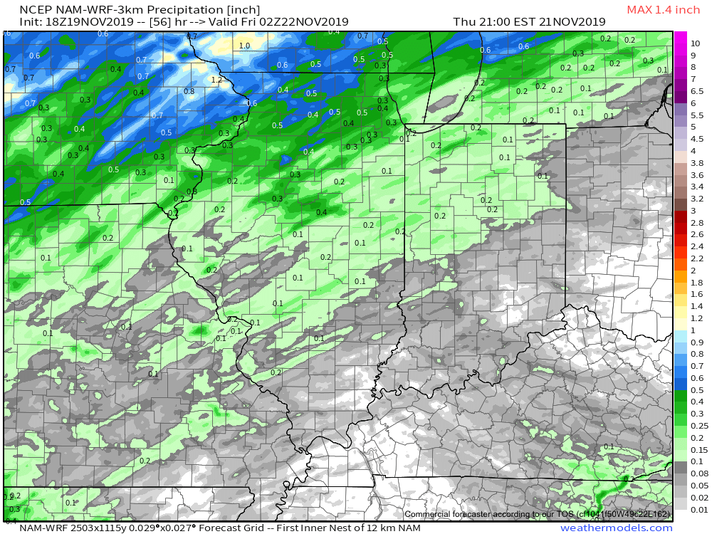
As we look ahead, rain will return to the region Thursday as an area of low pressure lifts into the Great Lakes region. This will drag a cold front through our region Thursday night into Friday morning. Looking at the most updated high resolution data suggests the steadiest rain will arrive around or just after lunchtime Thursday.

With that said, rainfall amounts aren’t anticipated to be significant. Most will be between 0.10” and 0.25” with a few heavier totals.
After a quiet Friday, moisture will overspread the region once again this weekend. This is the “follower” system modeling has struggled with over the past week. We were confident this would be a local player due to the overall upper level pattern, despite the inconsistent modeling. Sure enough, the consensus of modeling this evening brings in another system in the Saturday-Sunday time frame. With marginally cold air, this isn’t expected to be a widespread winter weather maker, but we continue to closely monitor the potential of localized “more meaningful” wintry precipitation across portions of the central and northern Ohio Valley. Note the wide range of possibilities individual GFS ensemble members print off:

We’ll continue to keep close tabs on things the next couple days and have a fresh update posted early tomorrow morning reviewing the latest overnight data. Specifics should become much more clear with regard to the weekend system once we get to Thursday…
Permanent link to this article: https://indywx.com/2019/11/19/evening-update-on-thursday-rain-weekend-mischief/
Nov 19
VIDEO: Updated Short Term And Longer Range Thoughts Into Early December…
You must be logged in to view this content. Click Here to become a member of IndyWX.com for full access. Already a member of IndyWx.com All-Access? Log-in here.
Permanent link to this article: https://indywx.com/2019/11/19/video-updated-short-term-and-longer-range-thoughts-into-early-december/
Nov 18
VIDEO: Gloomy Open To The Work Week…
You must be logged in to view this content. Click Here to become a member of IndyWX.com for full access. Already a member of IndyWx.com All-Access? Log-in here.
Permanent link to this article: https://indywx.com/2019/11/18/video-gloomy-open-to-the-work-week/
Nov 17
VIDEO: Week Ahead Outlook; Greenland Block Leads To An “Interesting” Pattern Around Thanksgiving…
You must be logged in to view this content. Click Here to become a member of IndyWX.com for full access. Already a member of IndyWx.com All-Access? Log-in here.
Permanent link to this article: https://indywx.com/2019/11/17/video-week-ahead-outlook-greenland-block-leads-to-an-interesting-pattern-around-thanksgiving/
Nov 16
Leader – Follower…
Our weekend weather will remain relatively quiet. Sure, we’ll have a weak system pass through the state Sunday afternoon. While this could deal out a light shower (potentially mixed with a little sleet), significant accumulation isn’t anticipated. This will allow us to look ahead to potential “more important” items down the road.
Initially, the flow will back to the southwest midweek, allowing a briefly milder regime to blow into the Ohio Valley for about 24-48 hours. An area of low pressure will track from the lee of the Colorado Rockies Tuesday, across the Plains and into the Great Lakes Thursday into Friday. This will result in a period of rain and gusty winds late Wednesday into Thursday. We’re not expecting particularly hefty rain with this system, with most central Indiana rain gauges around the 0.25″ to 0.50″ range.
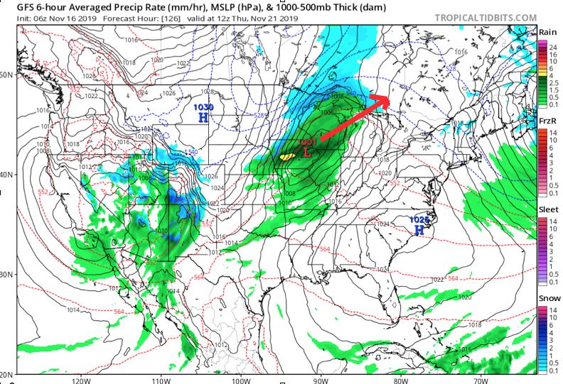
Once the low lifts into the Lakes, it’ll help sling a cold front through the Ohio Valley Thursday night. This will result in a much colder close to the work week.
As colder air is seeping into the region, additional upper level energy will be ejecting out of the Four Corners region Friday evening. Eventually, this will result in a surface wave developing over the mid-South region Friday night into Saturday morning.
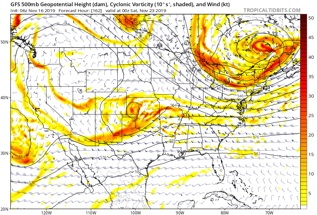
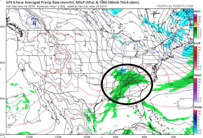
While the majority of operational data currently shows this wave remaining suppressed, history tells us we need to pay special attention to model trends over the next several days. All too often, seemingly “harmless” systems in the medium term that appear to scoot off to our south will trend north. The upper air pattern suggests this may be the case this go around as well.
As it is, some of the individual ensemble members are already jumping on this. Hunch here is that as we go through the upcoming week, a legitimate interior winter threat will be present for next weekend…

Permanent link to this article: https://indywx.com/2019/11/16/leader-follower/
Nov 15
VIDEO: Weak System Sunday; More Interesting Times Mid-Late Next Week…
You must be logged in to view this content. Click Here to become a member of IndyWX.com for full access. Already a member of IndyWx.com All-Access? Log-in here.
Permanent link to this article: https://indywx.com/2019/11/15/video-weak-system-sunday-more-interesting-times-mid-late-next-week/
Nov 14
VIDEO: Long Range Thoughts To Wrap Up November And Looking Ahead To December…
You must be logged in to view this content. Click Here to become a member of IndyWX.com for full access. Already a member of IndyWx.com All-Access? Log-in here.
Permanent link to this article: https://indywx.com/2019/11/14/video-long-range-thoughts-to-wrap-up-november-and-looking-ahead-to-december/
Nov 14
What A Start To November; Looking Ahead…
Indianapolis is running a whopping 11.7° below average through the 1st (13) days of the month. We’ve broken records for cold and snow so far, including Monday’s snow at 2.8″, record lows (8° on Tuesday and 9° low on Wednesday, and record low maximums (21° high on Tuesday).
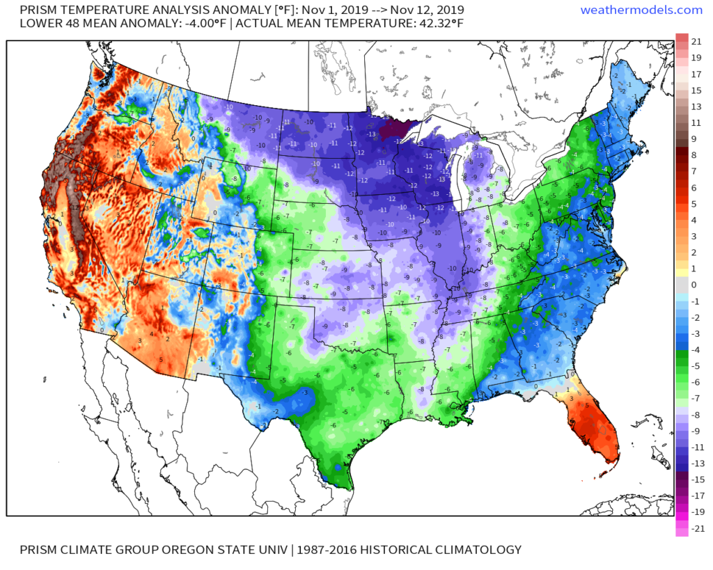
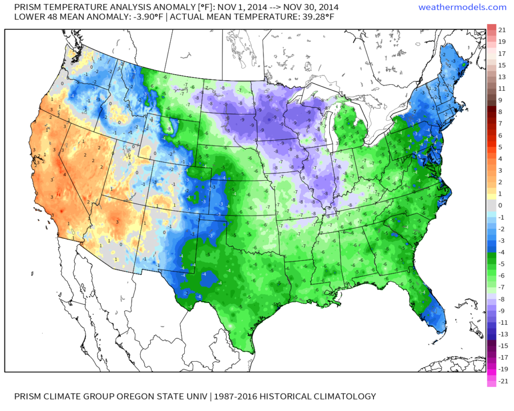
Shades of November ’14 come to mind with the way this month has started:
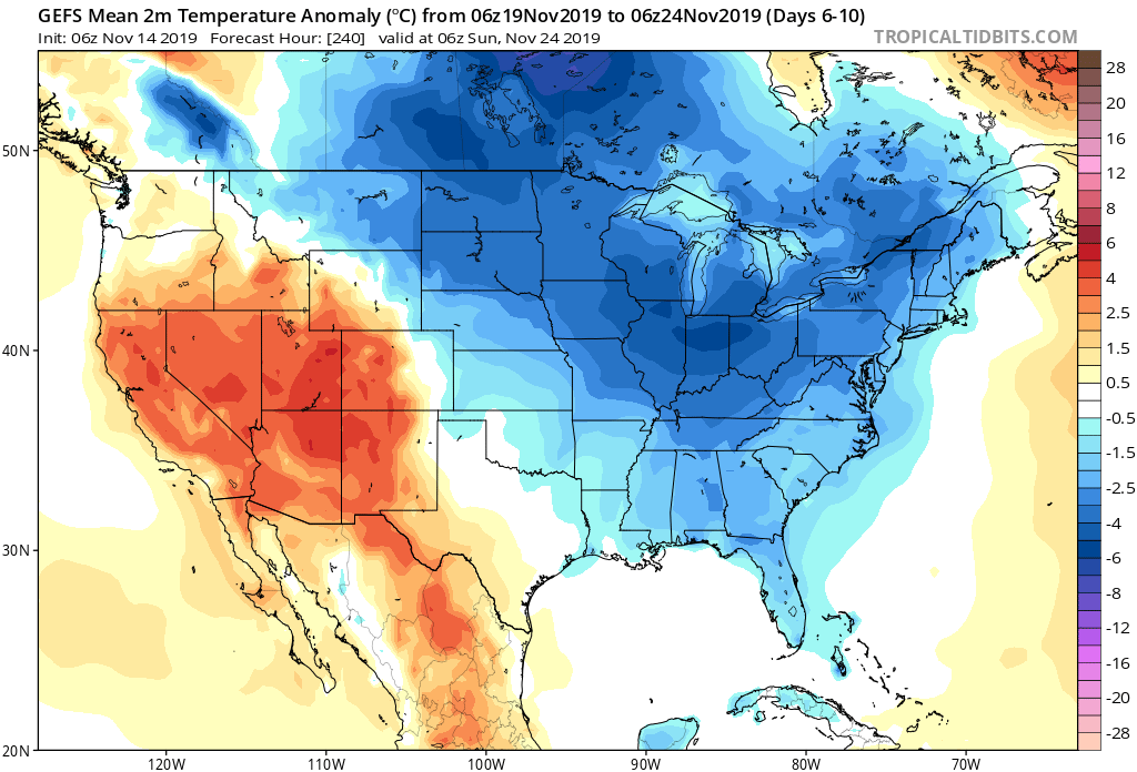
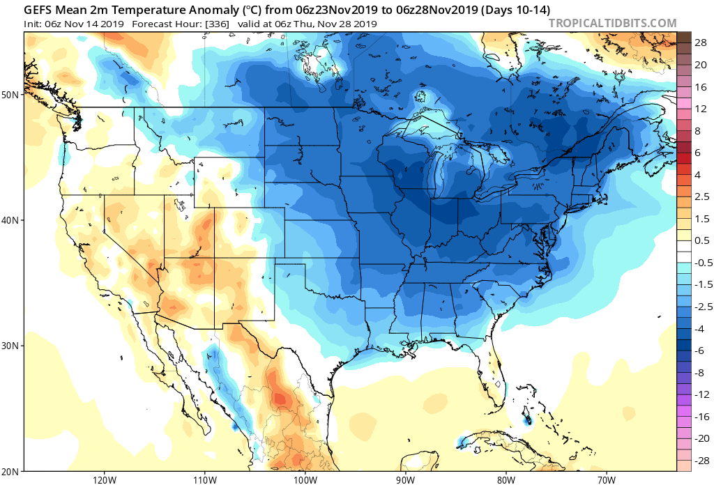
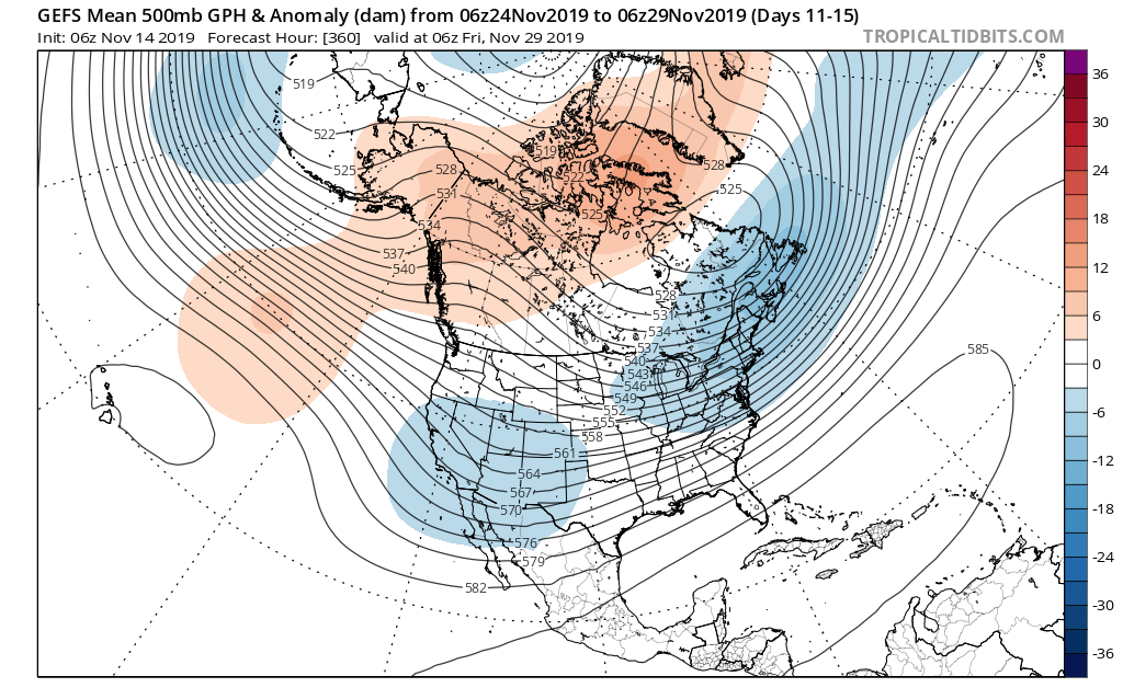
As we look ahead, temperatures are expected to remain below, to significantly below, average through the 2nd half of the month overall.
From a storm standpoint, we’re only expecting a couple of fairly weak systems over the upcoming week. A disturbance will scoot across central Indiana Sunday with a few light showers and again Tuesday. Neither is expected to provide significant moisture.
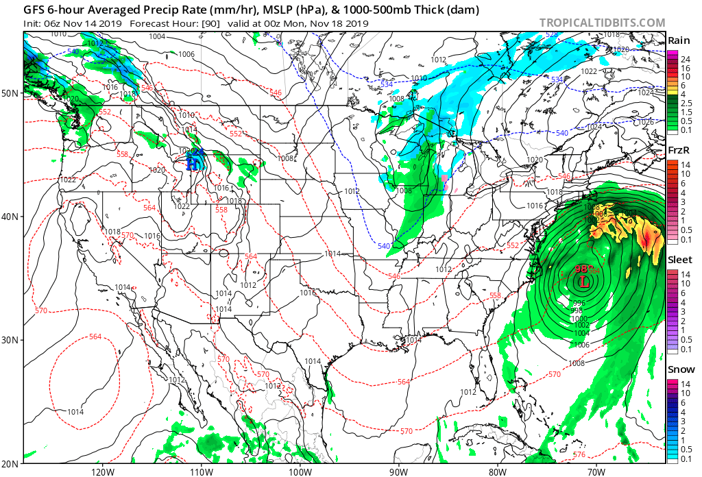
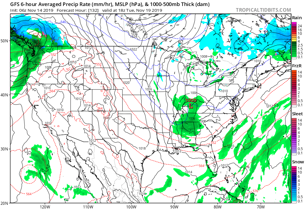
Things begin to potentially turn a little more “exciting” as we grow closer to Thanksgiving. The forecast upper air pattern is one that has “mischief” written all over it and will likely require more attention as time draws closer. More on this and some updated data (including the European and JMA Weeklies) later this evening with our long range video update.
Permanent link to this article: https://indywx.com/2019/11/14/what-a-start-to-november-looking-ahead/
