You must be logged in to view this content. Click Here to become a member of IndyWX.com for full access. Already a member of IndyWx.com All-Access? Log-in here.
October 2017 archive
Permanent link to this article: https://indywx.com/2017/10/24/video-a-much-colder-pattern-is-here-scattered-snow-showers-sunday/
Oct 23
Wet Start To The Work Week; Taste Of Winter This Weekend…
 Highlights:
- Wet, gloomy open to the work week
- Dry midweek
- Much colder this weekend
- First flakes of the season
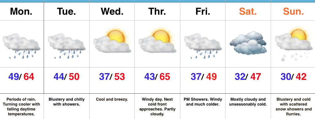
Rain Gear Required…Low pressure will track through the Ohio Valley and into the Great Lakes between now and Tuesday morning. This will result in a wet day, including periods of moderate to heavy rain. Once the cold front slips through central Indiana, we’ll notice slowly falling temperatures this afternoon. We’ll throw in a gusty NW breeze tonight into Tuesday with showers and chilly conditions remaining in place.
Drier air will work in for the midweek stretch. After patchy frost Wednesday, a cool, crisp day is on tap with increasing sunshine. Thursday will feature strong and gusty southwest winds (gusts over 40 MPH), but dry conditions ahead of an approaching cold front. That cold front will blow through here Friday with a band of showers and sharply colder air to end the work week.
The air will turn cold enough to end the growing season this weekend across central Indiana. Additionally, a combination of upper level energy and reinforcing cold air Sunday will interact with the unseasonably warm lake waters to help generate scattered snow showers and flurries. When we compare this upcoming Sunday to yesterday, it’ll add insult to injury as temperatures will be more than 30° colder…
The 2017-2018 IndyWx.com Winter Outlook is now available.
Upcoming 7-Day Precipitation Forecast:
- Snowfall: Trace
- Rainfall: 1.00″ – 2.00″
Permanent link to this article: https://indywx.com/2017/10/23/wet-start-to-the-work-week-taste-of-winter-this-weekend/
Oct 22
VIDEO: Heavy Rain Gives Way To Colder Air…
You must be logged in to view this content. Click Here to become a member of IndyWX.com for full access. Already a member of IndyWx.com All-Access? Log-in here.
Permanent link to this article: https://indywx.com/2017/10/22/video-heavy-rain-gives-way-to-colder-air/
Oct 22
So Long Warm Autumn Weather; Colder Changes Ahead This Week…
 Highlights:
- Bye-bye unseasonably warm weather
- Wet start to the work week
- Colder times loom
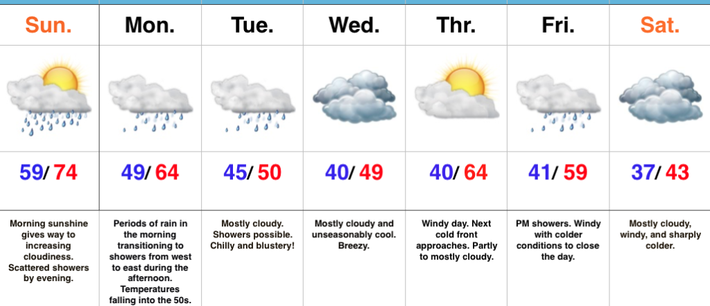
Early Sunday Sun; Rain Increases In Coverage Tonight…The morning is off to a pleasant start, including unseasonably mild conditions and a SW breeze. Clouds will thicken up this evening and a scattered shower will be possible. Rain will increase in coverage and intensity tonight into Monday as an area of low pressure tracks into the Ohio Valley and eastern Great Lakes by Tuesday morning. Steadiest rain will impact central Indiana Monday morning before diminishing to showers Monday afternoon and evening. Temperatures will fall into the 50s Monday morning into the afternoon.
A bigger “jab” of chilly air will plunge into the region for midweek. Considerable cloudiness will accompany the unseasonably chilly conditions, along with a gusty northwest breeze.
As we look ahead towards next weekend, another in a series of cold fronts (get used to that) will eye a Friday evening approach. Showers will be possible as this front blows through the region. Sharply colder air looms next weekend. Frost and freeze conditions will likely develop early next week, along with the first flakes of the season…
The 2017-2018 IndyWx.com Winter Outlook is now available!
Upcoming 7-Day Precipitation Forecast:
- Snowfall: 0.00″
- Rainfall: 1.25″ – 1.75″
Permanent link to this article: https://indywx.com/2017/10/22/so-long-warm-autumn-weather-colder-changes-ahead-this-week/
Oct 19
VIDEO: Heavy Rain Threat On The Table Early Next Week…
You must be logged in to view this content. Click Here to become a member of IndyWX.com for full access. Already a member of IndyWx.com All-Access? Log-in here.
Permanent link to this article: https://indywx.com/2017/10/19/video-heavy-rain-threat-on-the-table-early-next-week/
Oct 19
Calm And Sunny Now; Big Changes Ahead…
 Highlights:
- Sunny, pleasant weather continues for now
- Weekend cold front
- Much colder next week
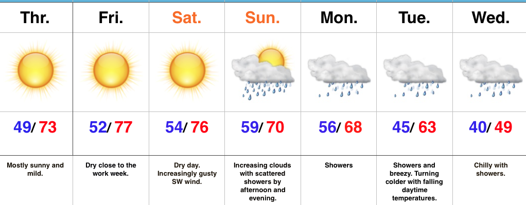
Easy, “Breezy” Forecast Into The Weekend; Questions Loom Thereafter…There’s really no need to waste a bunch of pixels on the short-term forecast. High pressure will remain in control and supply plentiful sunshine into the first half of the weekend. Mild temperatures will continue and we’ll add a gusty southwest breeze into the mix Saturday.
A cold front will approach the state Sunday and this will lead to increasing cloudiness along with scattered showers by the afternoon into the evening. Thereafter, questions loom around important details that will potentially increase what will, at the very least, be “nuisance” level showers and mist into mid week towards an all-out rain storm, including widespread 2″+ totals. Stay tuned as we continue to fine tune things. We’ll have an update later today.
One thing that hasn’t changed and doesn’t require us to ask any questions is the coming chill. Temperatures will fall through the day Tuesday and highs may not make it out of the 40s Wednesday…
It’s that time of year again! The annual IndyWx.com Winter Outlook will arrive on the site this weekend.
Upcoming 7-Day Precipitation Forecast:
- Snowfall: 0.00″
- Rainfall: 1.00″ – 1.50″
Permanent link to this article: https://indywx.com/2017/10/19/calm-and-sunny-now-big-changes-ahead/
Oct 18
VIDEO: 6-10 Day Harvest Outlook…
You must be logged in to view this content. Click Here to become a member of IndyWX.com for full access. Already a member of IndyWx.com All-Access? Log-in here.
Permanent link to this article: https://indywx.com/2017/10/18/video-6-10-day-harvest-outlook-2/
Oct 17
Sunny Days; Pattern Change On The Horizon…
 Highlights:
- Extended stretch of dry, sunny weather
- Late weekend cold front
- Much colder close to the month looms
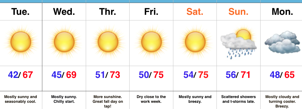
Ideal, Crisp Fall Day…Sheltered, lower lying communities are waking up to temperatures in the middle and upper 30s this morning with patchy frost. The rest of us are in the lower to middle 40s with just enough breeze preventing a deeper overnight fall. All of us we’ll moderate into the mid and upper 60s this afternoon under a clear sky. Those mostly sunny conditions will continue into mid and late week with moderating temperatures.
Our next storm system will arrive during the second half of the weekend in the form of a cold front. Scattered showers and thunderstorms will move in Sunday afternoon and evening ahead of the front. Cooler air will invade behind the frontal passage, but the true chilly stuff will press in early next week. Speaking of chilly weather, medium and longer range data continues to paint a cold close to the month and open to November. Warm costumes will be needed for trick-or-treating this year.
Upcoming 7-Day Precipitation Forecast:
- Snowfall: 0.00″
- Rainfall: 0.25″ – 0.50″
Permanent link to this article: https://indywx.com/2017/10/17/sunny-days-pattern-change-on-the-horizon/
Oct 16
VIDEO: 6-10 Day Harvest Outlook
You must be logged in to view this content. Click Here to become a member of IndyWX.com for full access. Already a member of IndyWx.com All-Access? Log-in here.
Permanent link to this article: https://indywx.com/2017/10/16/video-6-10-day-harvest-outlook/
Oct 15
Falling Temperatures Today; Dry Weather Returns…
 Highlights:
- Temperatures fall through the day
- Sunshine returns this week
- Pleasant stretch of weather ahead
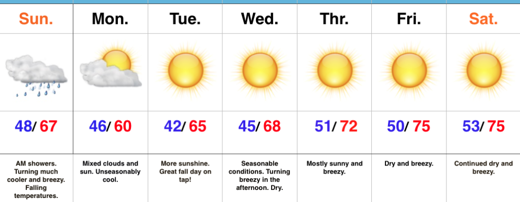
Jackets And Sweaters Required By This Afternoon…A cold front will continue to march east this morning and this will push a broken band of showers east through the state. Rainfall amounts won’t be significant, but will be enough to be a nuisance on the way to church or brunch this morning. This afternoon, we’ll notice an increasingly gusty breeze and falling temperatures. While it’s mild this morning, it’ll feel much cooler as we progress through the afternoon and evening hours. Jackets and sweaters will be required!
High pressure will settle overhead for the upcoming week and this will lead to an extended period of dry, pleasant weather. Temperatures will moderate from seasonably cool early-week to unseasonably mild by late-week. As expected, the late September and early October warmth (particularly warm overnight lows) really stunted our fall foliage this year. That said, the cool, calm nights ahead this week will be sufficient enough to at least ignite some of the remaining leaves on trees for what should be a couple weeks of “decent” color ahead.
Longer term, there are big goings on behind the scenes that will help drive a dramatically different weather pattern to wrap up the month of October and head into November. Heads up to the parents out there, you may want to nudge the kiddos into picking a warm costume this Halloween…
Upcoming 7-Day Precipitation Forecast:
- Snowfall: 0.00″
- Rainfall: 0.10″ – 0.25″
Permanent link to this article: https://indywx.com/2017/10/15/falling-temperatures-today-dry-weather-returns/
