 Highlights:
- Snow develops
- Bitterly cold air for March
- St. Patrick’s Day showers
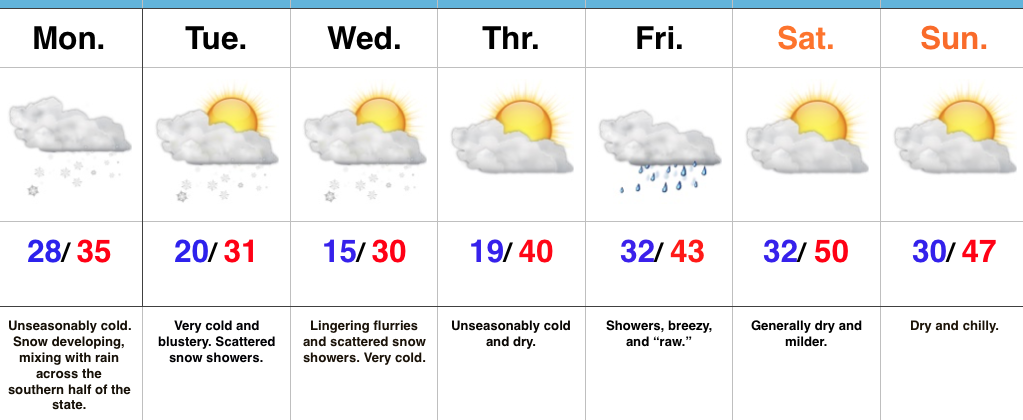
Snow Develops…Drier air is “eating away” at the snow shield as it attempts to advance eastward this morning. Eventually, we’ll moisten the atmosphere up enough to allow snow to push into the greater Indianapolis region by late morning. Snow will accumulate this morning, but marginal temperatures, that high March sun angle, and the fact most of the snow will be falling during the afternoon, we don’t anticipate accumulation issues this afternoon. Reinforcing cold air will filter back into the region tonight and last through mid week. With this late season arctic air, additional snow showers and embedded heavier squalls will continue. With all of that said, we don’t have any changes to our ongoing accumulation forecast. Expect an inch, or less, for the city, itself, increasing to 2″-5″ for north-central Indiana (where lake effect will add to the totals) for storm totals through Wednesday.
Dry conditions return late Wednesday and Thursday, but the cold will continue. Our next storm system arrives on the scene St. Patrick’s Day and with blustery, chilly conditions in place, showers added to the mix will feature “raw” weather conditions. As it stands now, we are going with a more optimistic approach for the weekend, including a dry forecast with increasing sunshine. After the cold week ahead, we will have earned it!
Upcoming 7-Day Precipitation Forecast:
- Snowfall: 1″ – 2″
- Rainfall: 0.25″ – 0.50″
