May 2016 archive
 Highlights:
- Band of showers and t-storms arrives late tonight
- Very cool and blustery weekend
- Drier pattern developing
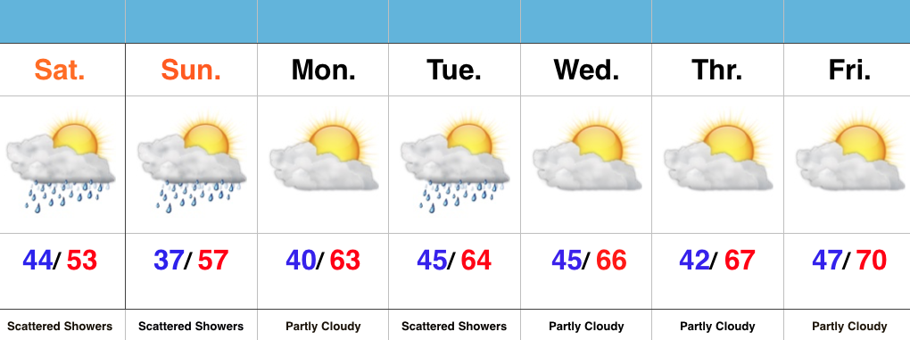
Unseasonably Chilly Weekend…A cold front is racing towards the region and will serve up a fresh batch of showers and thunderstorms overnight. The bigger story will be a gusty NW wind shift and falling temperatures late tonight. The chill will remain through the weekend with highs well below average and a patchy frost threat in outlying areas Sunday morning. Most of Sunday will be dry, but a widely scattered shower is possible during the afternoon hours.
The majority of the upcoming work week looks much drier when compared to recent. We’re watching a significant storm system, but general consensus of forecast model data at this point keeps the majority of significant rains to our south. We’ll keep a close eye on things. Slowly moderating temperatures can be expected as we progress through the week.
Permanent link to this article: https://indywx.com/chilly-blustery-weekend/
This content is password-protected. To view it, please enter the password below. Password:
You must be logged in to view this content. Click Here to become a member of IndyWX.com for full access. Already a member of IndyWx.com All-Access? Log-in here.
Permanent link to this article: https://indywx.com/client-long-range-video-discussion-2/
 Highlights:
- Scattered Showers And Storms
- Turning Much Cooler
- Unsettled Early Next Week
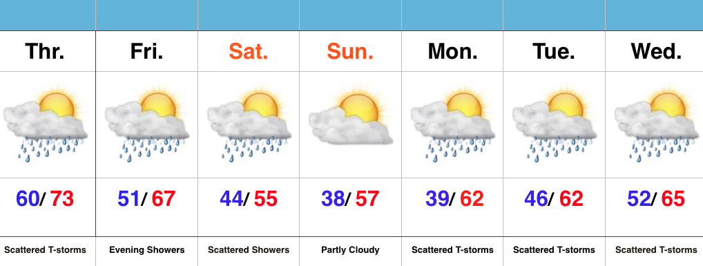
Have The Jackets Ready…The first of two cold fronts will sweep through the state this evening and help spark scattered strong to severe thunderstorms this afternoon and evening across mostly the eastern half of the state. A secondary cold front will move through here Friday evening with showers Friday night into early Saturday. It’s this second front that packs the much cooler air. Jackets will be required this weekend, and scattered light showers will remain in our forecast Saturday.
As we push into the new work week, things appear to be rather unsettled (what’s new)? An area of low pressure will push towards the region Tuesday into Wednesday and will increase rain and embedded storm chances. It won’t rain the entire time, but we’ll want the rain gear handy.
Permanent link to this article: https://indywx.com/scattered-strong-storms-this-afternoon-for-some/
 Highlights:
- Warm and humid mid week
- Turning much cooler for the weekend
- Unsettled times remain
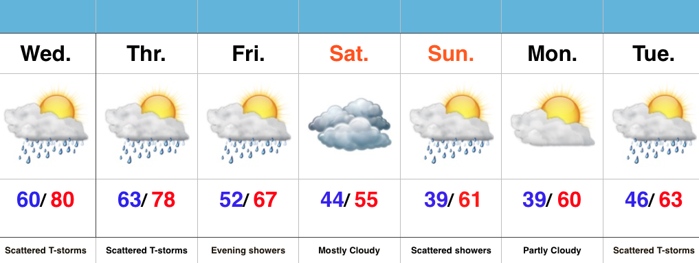
Jackets Required This Weekend…Wednesday’s coverage of showers and thunderstorms will likely be less than today, but will still require a mention of “scattered” coverage in our forecast. Some locally heavy downpours are possible, but like today, heavy rain totals won’t be uniform. Better coverage of showers and thunderstorms will move in early Thursday in association with a cold front. Once that cold front passes, expect a northwest wind shift and a much cooler feel of things to wrap up the work week and head into the weekend.
A weak disturbance will provide showers late Friday into the early morning hours Saturday, but this won’t amount to significant rain totals.
Cool times remain into early and middle parts of next week, with our next chance of significant rain slated for Tuesday.
Permanent link to this article: https://indywx.com/turning-much-cooler-to-close-the-week/
This content is password-protected. To view it, please enter the password below. Password:
You must be logged in to view this content. Click Here to become a member of IndyWX.com for full access. Already a member of IndyWx.com All-Access? Log-in here.
Permanent link to this article: https://indywx.com/client-long-range-discussion-2/
