March 19, 2016 archive
This content is password protected. To view it please enter your password below: Password:
You must be logged in to view this content. Click Here to become a member of IndyWX.com for full access. Already a member of IndyWx.com All-Access? Log-in here.
Permanent link to this article: https://indywx.com/2016/03/19/long-range-client-video-update/
 Highlights:
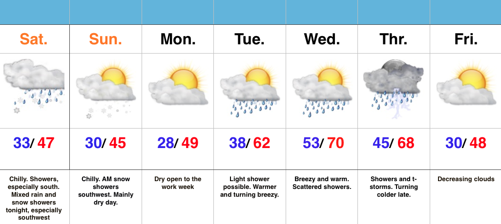
- Chilly, showery weekend- especially south
- Wet snow mixes with rain tonight into early Sunday morning
- Turning warmer by mid week
- Late week showers and storms
Chilly Weekend…We’re dealing with a much colder feel this weekend (jackets and coats required as you venture out to watch the “madness” at your favorite local spot later today). That said, not all of the region will deal with precipitation. This morning into the early afternoon, showers will be most widespread from Indy and points south. Later tonight, another band of precipitation will develop in association with upper level energy, but mainly be confined to the western and southwestern parts of the state. It’s within this band, that we expect wet snow to mix in. With the exception of some early morning snow showers tomorrow, drier air should win out for the majority of the day. It’ll remain colder than normal.
We’ll open the work week on a chilly, dry note, but a warm front will lift through the state Tuesday. A quick-hitting shower is possible as the front lifts north, but the bigger deal will be a noted SW wind shift (it’ll turn gusty) and a much warmer feel by afternoon/ evening. Better chances of showers and thunderstorms will rumble into the state Thursday before we turn quickly colder by Good Friday.
Interested in more in-depth long range forecast discussions, video updates, ag. forecasts, and seasonal outlooks? E-mail bill@indywx.com for more information.
Permanent link to this article: https://indywx.com/2016/03/19/chilly-weekend/

