This content is password-protected. To view it, please enter the password below. Password:
You must be logged in to view this content. Click Here to become a member of IndyWX.com for full access. Already a member of IndyWx.com All-Access? Log-in here.
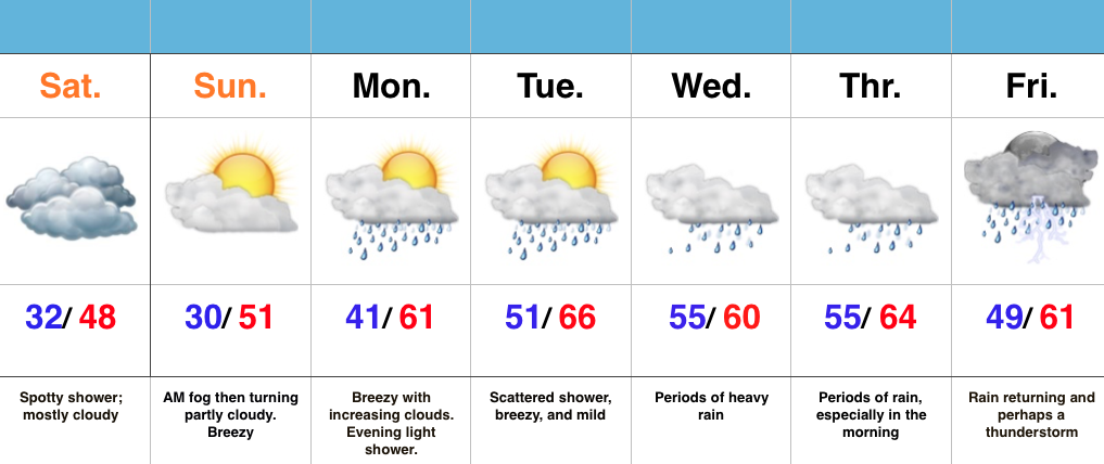
Mostly Cloudy Today; Brighter Sunday…A weak disturbance scooted through the region overnight and lead to a quick “pop” of mixed rain/ snow. As expected, this wasn’t a big deal. We’ll keep clouds around today, but introduce more in the way of sunshine Sunday (after morning fog).
A warmer SW flow will develop in the new week ahead and help transport much warmer air into the region, but this will also lead to an increasingly wet pattern. Spotty early week showers will give way to more widespread and heavier rains for the middle of the week. Timing is up in the air, but there’s the chance we get into some briefly drier air Thursday PM, but we caution it won’t last long as a new surge of moisture arrives to close the work week. We’ll also introduce thunder chances to wrap up the work week.
Interested in more in-depth long range forecast discussions, video updates, ag. forecasts, and seasonal outlooks? E-mail bill@indywx.com for more information.
This content is password-protected. To view it, please enter the password below. Password:
You must be logged in to view this content. Click Here to become a member of IndyWX.com for full access. Already a member of IndyWx.com All-Access? Log-in here.
Interested in more in-depth long range forecast discussions, video updates, ag. forecasts, and seasonal outlooks? E-mail bill@indywx.com for more information.
As we begin to transition from winter to spring this weekend, it’s not only the impressive early season warmth that has our attention next week, but also a developing wet pattern.
A combination of ingredients will result in a rather prolonged moist southwesterly air flow, with a Gulf of Mexico connection. The end result is a wet pattern developing, especially come mid week.
So while you get ready to enjoy the warmer than normal spring feel, it may also be wise to have the rain gear handy.
Interested in more in-depth long range forecast discussions, video updates, ag. forecasts, and seasonal outlooks? E-mail bill@indywx.com for more information.