This content is password-protected. To view it, please enter the password below. Password:
You must be logged in to view this content. Click Here to become a member of IndyWX.com for full access. Already a member of IndyWx.com All-Access? Log-in here.
Permanent link to this article: https://indywx.com/long-range-client-discussion-winter-isnt-finished/
This content is password-protected. To view it, please enter the password below. Password:
You must be logged in to view this content. Click Here to become a member of IndyWX.com for full access. Already a member of IndyWx.com All-Access? Log-in here.
Permanent link to this article: https://indywx.com/long-range-client-discussion-and-video-update-2/
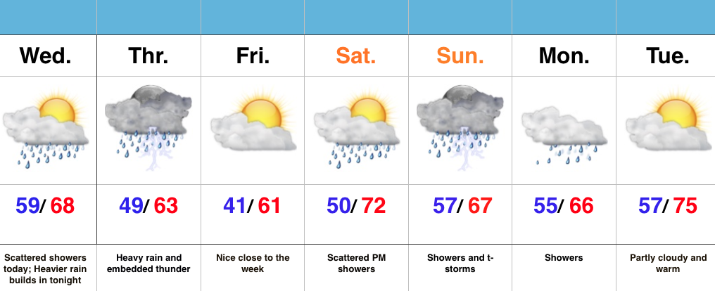 Highlights:
- Heavier rains arrives on scene tonight-Thursday
- Dry, nice close to the work week
- Weekend rain and storm return
- Very warm early next week
Good Sleeping Weather Tonight…Today will offer up scattered showers, but it’s really tonight through Thursday afternoon that has us focused for most widespread and heavier rain (along with embedded thunder). This is the first of two “slugs” of moisture that will provide hefty rain totals between now and early next week. The second surge of moisture will arrive late Saturday into the day Sunday. The trade off? An absolutely beautiful close to the work week.
Once we shake the rain early next week, we’ll really crank the thermometer. We expect middle 70s next Tuesday across most of central IN. We caution though that colder times loom around March 20th. Don’t put away the winter gear just yet…
7-Day Precipitation Forecast:
- Snowfall: 0.00″
- Rainfall: 2.00″ – 2.50″ (locally heavier totals)
Interested in more in-depth long range forecast discussions, video updates, ag. forecasts, and seasonal outlooks? E-mail bill@indywx.com for more information.
Permanent link to this article: https://indywx.com/heavier-rain-builds-in-tonight/
This content is password-protected. To view it, please enter the password below. Password:
You must be logged in to view this content. Click Here to become a member of IndyWX.com for full access. Already a member of IndyWx.com All-Access? Log-in here.
Permanent link to this article: https://indywx.com/long-range-client-discussion-and-video-update/
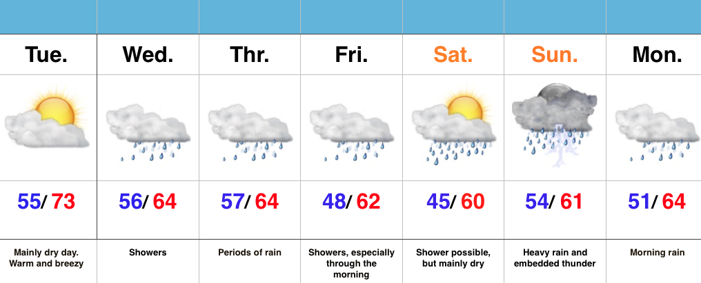 Highlights:
- Warm, mostly dry Tuesday
- Rain builds in mid week
- Weekend questions
Enjoy Today’s Sun…Today looks to be the pick of the week, including mostly dry conditions and temperatures that will feel more like April. Find a way to get out and enjoy it!
Moisture will surge northeast into the region during the day Wednesday and a wavy front will sag south into the area to close the work week. The combination of a deep moisture transport out of the Gulf will help ignite locally heavy downpours. While questions are certainly there in regards to timing, we’re leaning more towards the optimistic side of things with this update…thinking enough dry air may invade the area for a mostly dry Saturday. This is an, admittedly, low confidence forecast.
Regardless of whether or not we can enjoy a mostly dry start to the weekend, moisture will stream back into the area for the second half of the weekend. Heavy rain and embedded thunder looks likely Sunday.
7-Day Precipitation Forecast:
- Snowfall: 0.00″
- Rainfall: 2.00″ – 2.50″
Permanent link to this article: https://indywx.com/warm-pattern-turns-increasingly-wet/

