 Highlights:
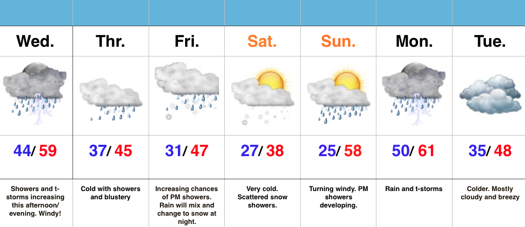
- Increasing rain chances today
- Turning colder and continued unsettled to wrap up the work week
- Snow showers Friday night-Saturday
- Wet start next week
Active Times Continue…Despite some thunderstorms across northern portions of the state this morning, most are dry. That will change this afternoon and evening as widespread showers and embedded thunder increase in coverage. On average, expect 0.25″-0.50″ by tonight. Winds will also be gusty (40 MPH+).
We’ll shift into a much colder pattern to wrap up the work week and upper level energy will help produce showers Thursday. As even colder air gets involved, rain will transition to snow Friday night into Saturday morning. Saturday will be downright cold.
Another wet weather maker approaches early next week. After a hard freeze Sunday morning, things will cloud up, turn windy, and feature evening showers. More widespread rains and storms arrive on the scene Monday. Colder air returns Tuesday!
Permanent link to this article: https://indywx.com/cold-and-unsettled-pattern/
This content is password-protected. To view it, please enter the password below. Password:
You must be logged in to view this content. Click Here to become a member of IndyWX.com for full access. Already a member of IndyWx.com All-Access? Log-in here.
Permanent link to this article: https://indywx.com/long-range-client-discussion-7/
This content is password-protected. To view it, please enter the password below. Password:
You must be logged in to view this content. Click Here to become a member of IndyWX.com for full access. Already a member of IndyWx.com All-Access? Log-in here.
Permanent link to this article: https://indywx.com/long-range-client-discussion-6/
 Highlights:
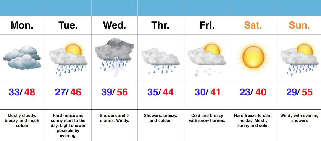
- Prolonged unseasonably chilly pattern
- Mid week thunderstorms
- Snow flurries and another hard freeze late week
Have The Jackets And Sweaters Handy…A cold front slipped through central IN this morning and a NW wind shift is already doing the “dirty work” in delivering a much colder air mass to greet us out the door this morning. Get used to it, as a very chilly week is on tap!
A hard freeze will occur tonight as skies turn mostly clear and winds diminish. Tuesday will dawn sunny, but clouds will increase late and a light shower is possibly by the evening hours.
Better coverage of showers and thunderstorms will push into the region Wednesday morning. While it’ll be briefly warmer (still slightly below average though), don’t get used to it. Much colder air will be with us to wrap up the work week.
A secondary push of late season arctic air will blow into town Thursday with showers before transitioning to snow flurries/ scattered snow showers Friday morning. The coldest morning in this late season chilly pattern looks to arrive Saturday morning, including widespread lower 20s.
Permanent link to this article: https://indywx.com/chilly-pattern/
This content is password-protected. To view it, please enter the password below. Password:
You must be logged in to view this content. Click Here to become a member of IndyWX.com for full access. Already a member of IndyWx.com All-Access? Log-in here.
Permanent link to this article: https://indywx.com/long-range-client-discussion-5/

