An unsettled week ahead will feature periods of more widespread rain and stronger storms at times between now and Wednesday. We’re focused on Tuesday for the potential of strong to…
You must be logged in to view this content. Click Here to become a member of IndyWX.com for full access. Already a member of IndyWx.com All-Access? Log-in here.
Permanent link to this article: https://indywx.com/monday-morning-video-update-strong-storms-tuesday-much-colder-end-to-the-week/
This content is password-protected. To view it, please enter the password below. Password:
You must be logged in to view this content. Click Here to become a member of IndyWX.com for full access. Already a member of IndyWx.com All-Access? Log-in here.
Permanent link to this article: https://indywx.com/long-range-client-video-update-and-a-word-on-summer/
 Highlights:
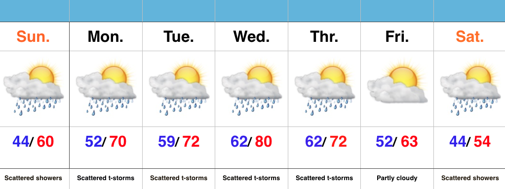
- Cool Mother’s Day
- Periods Of Rain And Storms
- Another Cool Blast Looms
Have The Rain Gear Handy; Don’t Put Away Those Coats…A “wavy” frontal boundary will remain in our general vicinity over the next few days and be responsible for offering up periods of showers and eventually thunderstorms (as warmer, more humid air surges in Monday). It’s a “rinse and repeat” pattern this week as daily shower and thunderstorm chances continue. Models are in agreement on rain amounts of 1.5″-2″ between now and Thursday night, with locally higher amounts.
Eventually, a cold front will sweep through the state Thursday evening and set up a MUCH cooler than normal weekend. Instability-driven showers are possible Saturday, but the big story will be the unseasonably chilly air over the weekend into early next week.
Permanent link to this article: https://indywx.com/unsettled-week-another-cool-blast-looms/
This content is password-protected. To view it, please enter the password below. Password:
You must be logged in to view this content. Click Here to become a member of IndyWX.com for full access. Already a member of IndyWx.com All-Access? Log-in here.
Permanent link to this article: https://indywx.com/long-range-client-video-update-7/
 Highlights:
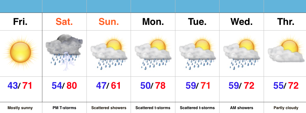
- Pick of the week is today
- Evening severe potential Saturday
- Unsettled stretch continues
Have The Sunglasses Handy Today…Today is easily the pick of the week as high pressure supplies sunshine and a cool start. With the May sun angle in place, chilly morning lows in the lower 40s will quickly rise into the lower 70s for afternoon highs.
A cold front will approach Saturday and slice into a briefly warm and humid air mass in place across the region. With highs approaching 80 and dew points surging into the lower 60s, don’t be surprised by strong to severe thunderstorms across central IN during the afternoon and evening hours.
The cold front will slip to our south for Sunday, but remain close enough to continue shower chances across central parts of the state. It’ll be a much cooler day with a north wind in play.
As we move into the new work week, we’ll continue the active and unsettled theme. While it won’t rain the entire time, expect numerous showers and embedded thunderstorms through mid week.
Permanent link to this article: https://indywx.com/fantastic-friday-storms-return-saturday-evening/

