
You must be logged in to view this content. Click Here to become a member of IndyWX.com for full access. Already a member of IndyWx.com All-Access? Log-in here.
Permanent link to this article: https://indywx.com/indy-500-and-memorial-day-weekend-video-update/
May 24
Turning Much More Humid…
 Highlights:
- Oppressive feel develops
- Scattered storms to close the week
- Less storm coverage for the 500 and Memorial Day
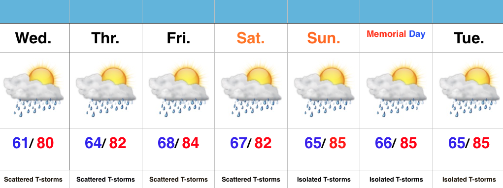
Ready To Sweat? A much more humid and oppressive feel will develop Wednesday (dew points likely surge to 70 by afternoon). Along with the muggy air mass, we expect scattered showers and embedded thunderstorms to develop. We’ll maintain mention of scattered storms into the weekend, but want to stress that these won’t be uniform in the least. That said, with all of the moisture in the air, stronger storms will be capable of producing locally heavy rainfall.
We continue to keep a close eye on the data for Sunday and Monday. Thankfully, latest indications suggest we see an overall decrease in aerial coverage of showers and storms both days. We’ll call it “isolated” for now. It’ll be plenty hot and humid.
Permanent link to this article: https://indywx.com/turning-much-more-humid/
May 23
Protected: June Outlook…
This content is password-protected. To view it, please enter the password below. Password:
You must be logged in to view this content. Click Here to become a member of IndyWX.com for full access. Already a member of IndyWx.com All-Access? Log-in here.
Permanent link to this article: https://indywx.com/june-outlook/
May 23
Not As Bad As It May Look…
 Highlights:
- Dry feel turns much more humid
- Splash and dash storms, but many dry hours
- Warm, humid Memorial Day/ Race weekend
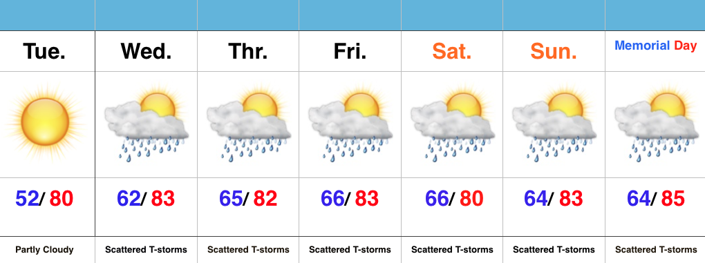
One More Dry Day…High pressure is scooting away from the region, but will remain close enough to supply central IN with dry conditions Tuesday. Though warm, we’ll enjoy one more day with dry air in place.
A SW wind shift will deliver an increasingly moist air mass for mid week, continuing into the long holiday and race weekend ahead. In fact, dew points will surge to readings around 70 (downright oppressive). While there will be times of scattered showers and thunderstorms, there will also be many dry hours, as well. We continue to keep an eye on Wednesday for the potential of a strong to severe storm.
As we continue to grow closer to the holiday and race weekend, questions continue to increase around the forecast specifics, and rightfully so. While we need to be prepared for an afternoon/ evening storm, these will be scattered and there will be “haves and have nots” when it comes to storm/ rain activity over the balance of the upcoming forecast period. Again, we want to emphasize there should be plenty of dry time.
Permanent link to this article: https://indywx.com/not-as-bad-as-it-may-look/
May 22
Protected: Client Long Range Video Update…
This content is password-protected. To view it, please enter the password below. Password:
You must be logged in to view this content. Click Here to become a member of IndyWX.com for full access. Already a member of IndyWx.com All-Access? Log-in here.
Permanent link to this article: https://indywx.com/client-long-range-video-update-7/
