A quick update on our thinking for this evening, continuing into Race Day!
You must be logged in to view this content. Click Here to become a member of IndyWX.com for full access. Already a member of IndyWx.com All-Access? Log-in here.

May 28
A quick update on our thinking for this evening, continuing into Race Day!
You must be logged in to view this content. Click Here to become a member of IndyWX.com for full access. Already a member of IndyWx.com All-Access? Log-in here.
Permanent link to this article: https://indywx.com/race-memorial-day-weekend-video-update/
May 28
This content is password-protected. To view it, please enter the password below. Password:
You must be logged in to view this content. Click Here to become a member of IndyWX.com for full access. Already a member of IndyWx.com All-Access? Log-in here.
Permanent link to this article: https://indywx.com/long-range-client-update-turning-busy-again/
May 28
 Highlights:
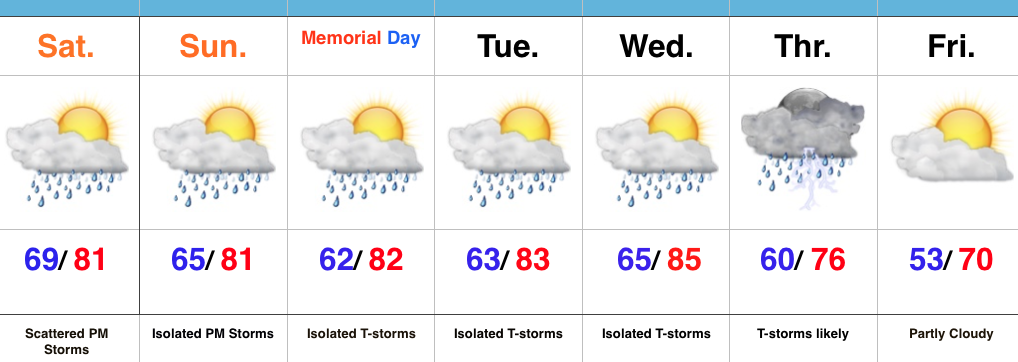
Better Coverage Of PM Storms…A warm, humid, and increasingly unstable air mass will be present today. Throw in a couple weak upper level disturbances lifting through the region and we should see a better coverage of afternoon/ evening thunderstorm activity when compared to the past couple days. Some locally heavy rainfall will be possible.
Thankfully, aerial coverage of showers and storms will diminish Sunday and Memorial Day, itself. We’ll maintain mention of an isolated to widely scattered storm. Conditions will remain warm and humid.
Our next best chance of rain and storms will push in Thursday. This is in association with a cold front. Behind this cold front, expect a big push of refreshing, unseasonably cool air to blow into town to close the work week. Temperatures grow cooler next weekend (lows at night in the 40s are possible).
Permanent link to this article: https://indywx.com/better-chance-of-afternoon-evening-storms-today-big-cool-down-looming/
May 26
 Highlights:
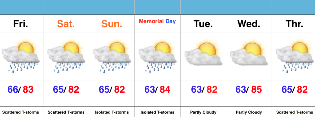
Not A Bad Forecast…The overall theme with tonight’s forecast package is warm and humid. While scattered thunderstorms will remain in our forecast Friday and Saturday, overall coverage of thunderstorm activity will diminish Sunday-Monday (isolated coverage both days). From this distance, the Indy 500 weather looks nice- just an isolated storm threat and quite warm. Widespread rain totals should remain below half an inch through the weekend, but we caution that locally heavier totals will certainly be possible (though it’s impossible to be precise where exactly those heavier showers and storms track).
Drier times will greet us as we return to work Tuesday, but we’ll be eyeing an approaching late week cold front by this time. This front will present our next chance of widespread shower and thunderstorm activity, along with a transition to a much cooler air mass just beyond the forecast period.
Permanent link to this article: https://indywx.com/warm-and-humid-more-dry-time-than-stormy/
May 26
This content is password-protected. To view it, please enter the password below. Password:
You must be logged in to view this content. Click Here to become a member of IndyWX.com for full access. Already a member of IndyWx.com All-Access? Log-in here.
Permanent link to this article: https://indywx.com/long-range-client-update/
