
You must be logged in to view this content. Click Here to become a member of IndyWX.com for full access. Already a member of IndyWx.com All-Access? Log-in here.
Permanent link to this article: https://indywx.com/stormy-for-some-this-morning-transient-pattern-into-august/
Jul 24
Unsettled, But A Better Feel Coming…
 Highlights:
- Storm chances increase tonight-Monday morning
- Drier, cooler air on deck
- Widespread storms Thursday
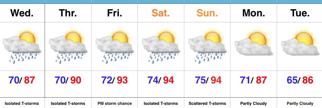
Hang In There…It’s been a long couple of days with high heat and humidity, but relief is in sight. A cold front will move through the state Monday. Ahead of this front, a band of showers and thunderstorms will slide through Indiana. A few of these storms could be strong with locally heavy rain. Best chances of storms across central IN appear to arrive tonight and Monday morning, before transitioning to southern IN Monday afternoon. Drier air will arrive Tuesday into Wednesday.
Our next rain and storm chances are dialed up for Thursday and early indications suggest this could be a fairly widespread event. Though we’ll maintain rain chances next weekend, coverage will diminish when compared to Thursday. Temperatures will be much more tolerable than what we’re dealing with today.
Upcoming 7-Day Precipitation Forecast:
- Snowfall: 0.00″
- Rainfall: 0.75″-1.25″ (Locally heavier totals)
Permanent link to this article: https://indywx.com/unsettled-but-a-better-feel-coming/
Jul 21
Thursday Evening Rambles…
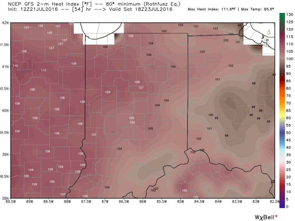
1.) A big ole ridge will supply oppressive heat and humidity across the Mid West this weekend. Unseasonably hot temperatures will combine with downright “soupy” air to create heat indices between 105-110 degrees across central IN this weekend. Take it easy and implement frequent breaks if your plans take you outdoors.
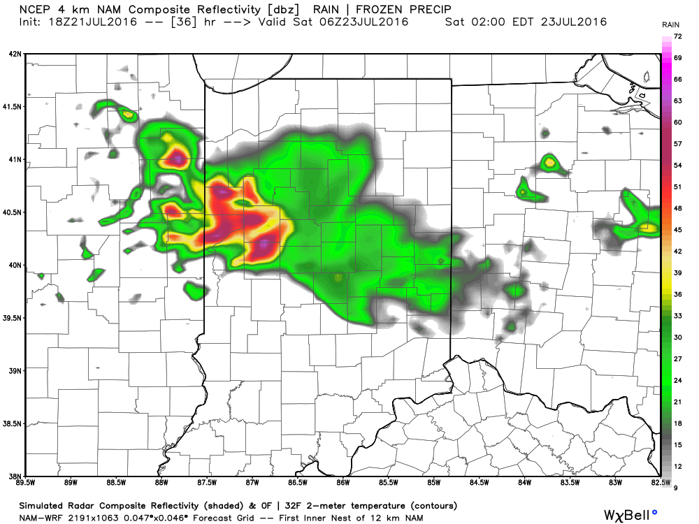
2.) Similar to what we’re seeing on radar this evening, thunderstorms will also make an appearance from time to time for some. With an atmosphere loaded with moisture, any storm that develops will be plenty capable of producing “frog straggler” type rainfall rates. Perhaps there will be a couple periods of more concentrated storm activity, focused on late tomorrow night and early Saturday, and again late Saturday night-Sunday morning. We’ll keep an eye on things.
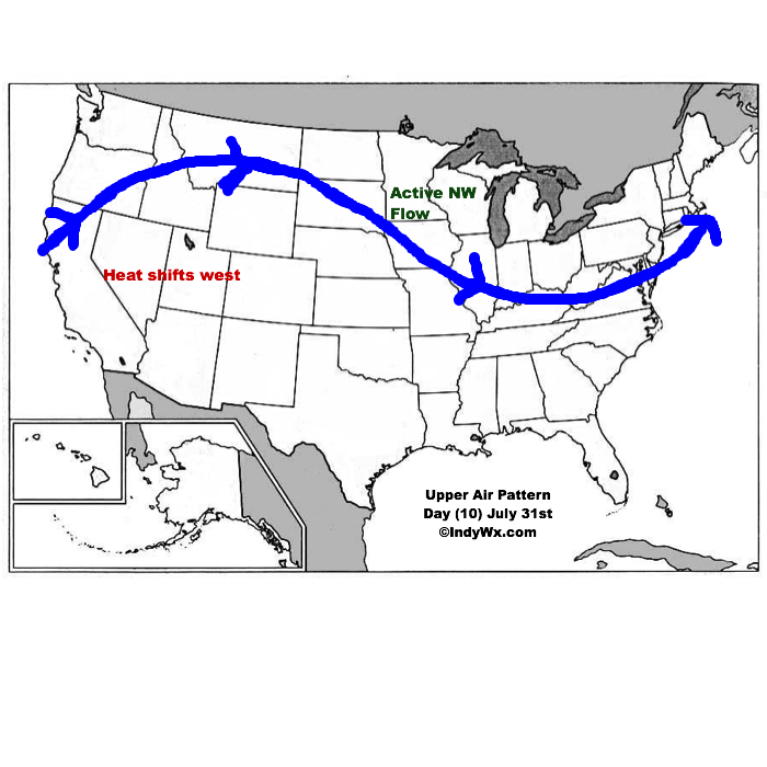
3.) The pattern is one (as has been the case all summer) that’s transient and the situation that develops to wrap up July and open August is an all-too-familiar look around these parts: NW flow aloft that offers storm potential, along with seasonal to slightly warmer than average. It’s a wet look, overall.
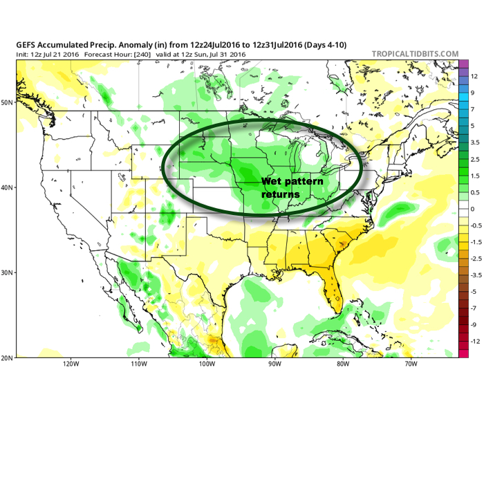
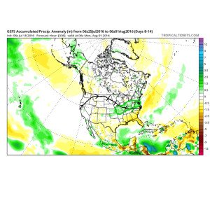
10-Day GFS rainfall numbers are impressive across the Mid West. Soaking rains for many. Courtesy Weatherbell.com
This is what the upper air pattern should look like as we close July- 10 days from now (hard to believe)!
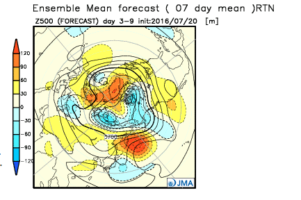
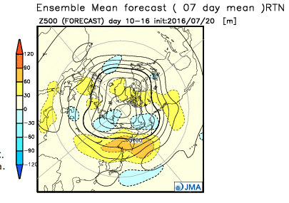
4.) Looking further ahead, the latest JMA Weeklies continue to suggest the most sustained hot pattern should remain across the west as we rumble deeper into August. That’s not to say we won’t deal with periods of hot weather here at times, but sustained heat will be hard to come by with such a pattern…
Permanent link to this article: https://indywx.com/thursday-evening-rambles-2/
Jul 20
Cranking Up The Heat…
 Highlights:
- Much more dry time than stormy
- Heat and humidity reach dangerous levels this weekend
- Cooler next week
Splash And Dash Storms, But Most Remain Dry…A quick glance at the forecast above may suggest wet times, but don’t let that fool you. “Isolated” and “scattered” are key words. While we’re still keeping an eye on the potential of a more widespread complex of storms late tonight/ early Thursday, we’re far from confident on the precise location of this potential storm complex and short term modeling isn’t offering up much help. Regardless, with such a muggy air mass in place, an isolated storm could fire anytime between now and the weekend. There are a couple periods we’re watching for more concentrated storm potential (Friday evening and Sunday). Timing remains fluid.
The big story with this forecast remains the heat and humidity. Temperatures will soar into the middle 90s this weekend and when you combine those hot readings with dew points in the lower and middle 70s, dangerous conditions result for anyone with longstanding outdoor plans. Have a means of taking frequent breaks and receiving plenty of water. The heat and humidity this weekend will be a serious situation.
Upcoming 7-Day Precipitation Forecast:
- Snowfall: 0.00″
- Rainfall: 0.25″-0.50″ (locally heavier totals)
Permanent link to this article: https://indywx.com/cranking-up-the-heat/
Jul 18
Heat Builds Late Week, But Doesn’t Last…
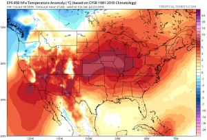
The pattern remains in a transient state. An upper ridge will build over the region late week into the weekend. With this will come the hottest air of the season (multiple days of lower to middle 90s starting Friday, continuing into early next week). The hottest days appear slated for Friday and Saturday. Heat indices will approach 105 degrees.
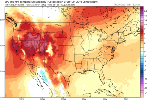
However, just as fast as the ridge builds over the area, we see the “want” to position itself over the Rocky Mountain region.
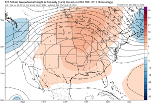
Hot dome will provide a couple days of highs in the middle 90s Friday-Saturday. Image courtesy of Tropicaltidbits
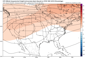
Note the difference of the ridge position by Day 10. Courtesy of Tropicaltidbits
 While some oppressive heat and humidity will impact our local area to wrap up the work week and head into the weekend, this is a pattern where it’s incredibly difficult to deal with any sort of one particular weather pattern for any time of substance. Looking forward to August, we don’t see this changing. Remember that word we leaned on to begin summer? “Transient” remains the best way to describe the pattern moving forward, as well.
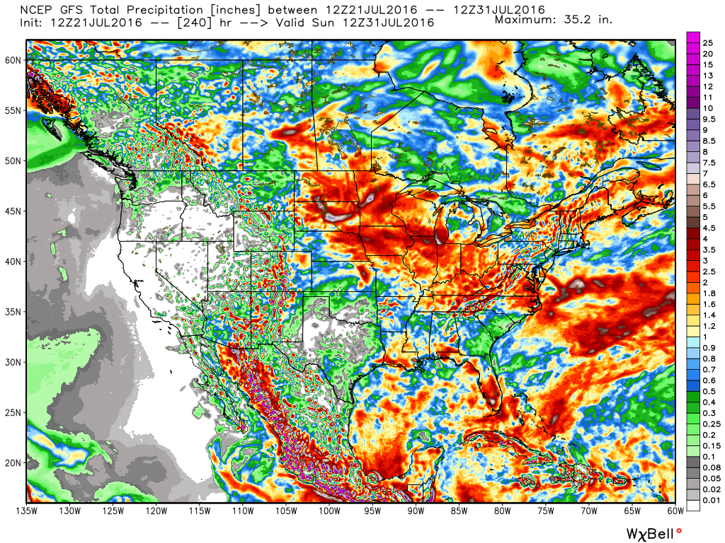
Additionally, this is a pattern that should result in a return of wet and active times as we put a wrap on July and welcome August. It’s impossible to nail down the precise details of any one particular neighborhood’s rainfall numbers from this distance, but understand the pattern is one that should yield more locally hefty rains in the weeks ahead.
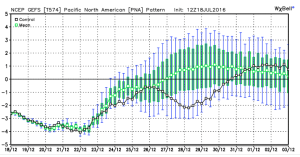
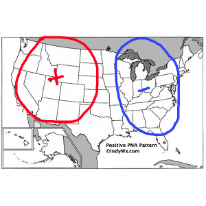
 To close, we’ll leave you with a look at the latest PNA pattern. This has been the primary driver of our weather this summer, and it also argues any sort of dry, hot weather doesn’t last. Note the positive PNA returning to close July. This also lines up well with our idea of unsettled times returning…
Permanent link to this article: https://indywx.com/heat-builds-late-week-but-doesnt-last/
