 Highlights:
- Showers and breezy conditions thanks to what’s left of Irma
- Sunshine returns
- Warmth builds
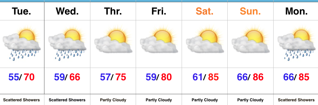
Irma’s Remnants…What’s left of Irma will begin to impact the state today. As promised, this won’t be a big deal, locally. We’ll notice scattered to numerous showers lifting north through the day, continuing Wednesday. Greatest overall rainfall coverage across central parts of the state should occur tonight into Wednesday. We’ll also note east and northeast winds gusting over 20 MPH at times. All in all, not a big weather event in the least for our region and our thoughts and prayers remain with our neighbors to our south beginning clean up/ rebuilding efforts.
High pressure will return as we wrap up the work week and move into the weekend. Additionally, a southerly air flow will help pump unseasonably warm conditions northward to encompass the Ohio Valley and Mid West. Our next weather maker will be a cold front that will make a run at the region Monday. Early indications are this front will “wash out” as it nears the region with only a few showers/ embedded thunder expected.
Looking ahead, much more active times loom as we progress through late September and open October…
Upcoming 7-Day Precipitation Forecast:
- Snowfall: 0.00″
- Rainfall: 0.25″ – 0.50″
Permanent link to this article: https://indywx.com/irmas-remnants-limp-into-the-region-warming-up-this-weekend/
-
Filed under AG Report, Autumn, European Model, Forecast Discussion, Forecast Models, Irma, Rain, Summer, Unseasonably Cool Weather, Unseasonably Warm, Windy
-
September 11, 2017
Irma: Irma’s remnants will begin to impact the state Tuesday. We noticed an increasing mid and high level cloud deck today and moisture will spread north to encompass southern Indiana…
You must be logged in to view this content. Click Here to become a member of IndyWX.com for full access. Already a member of IndyWx.com All-Access? Log-in here.
Permanent link to this article: https://indywx.com/monday-evening-rambles-looking-towards-october/
-
Filed under 7-Day Outlook, Autumn, Forecast Discussion, Forecast Models, Heavy Rain, Irma, Rain, Summer, Unseasonably Cool Weather, Unseasonably Warm, Weather Videos, Windy
-
September 11, 2017
You must be logged in to view this content. Click Here to become a member of IndyWX.com for full access. Already a member of IndyWx.com All-Access? Log-in here.
Permanent link to this article: https://indywx.com/video-hurricane-irma-and-warmer-times-loom/
 Highlights:
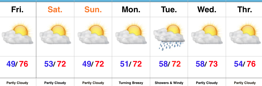
- Plentiful sunshine
- Unseasonably cool
- Watching Irma
High Pressure Dominates…There’s no reason to get “wordy” with the short-term forecast, as high pressure will dominate our region. This will result in plentiful sunshine, low humidity, and unseasonably cool, refreshing temperatures. Find time to spend the weekend outside!
All eyes will most certainly be on dangerous Hurricane Irma as she begins to impact the Florida peninsula as early as Saturday. Our thoughts and prayers are with all in Irma’s path, including interior portions of the southeast that will also deal with hurricane conditions late in the weekend into early next week. Here on the home front, we still only expect minimal impacts from Irma. We’ll notice an increasingly gusty easterly breeze late Monday into Tuesday. Additionally, showers are possible (especially across the southern half of the state) Tuesday.
Upcoming 7-Day Precipitation Forecast:
- Snowfall: 0.00″
- Rainfall: 0.10″ – 0.25″
Permanent link to this article: https://indywx.com/chamber-of-commerce-weather/
As of this update (4p Thursday), Irma remains a powerful Category 5 hurricane with 175 MPH winds, moving WNW at 16 MPH. Some fluctuations in strength are likely over the…
You must be logged in to view this content. Click Here to become a member of IndyWX.com for full access. Already a member of IndyWx.com All-Access? Log-in here.
Permanent link to this article: https://indywx.com/thursday-afternoon-quick-word-on-irma/

