
You must be logged in to view this content. Click Here to become a member of IndyWX.com for full access. Already a member of IndyWx.com All-Access? Log-in here.
Permanent link to this article: https://indywx.com/video-6-10-day-harvest-outlook/
Oct 15
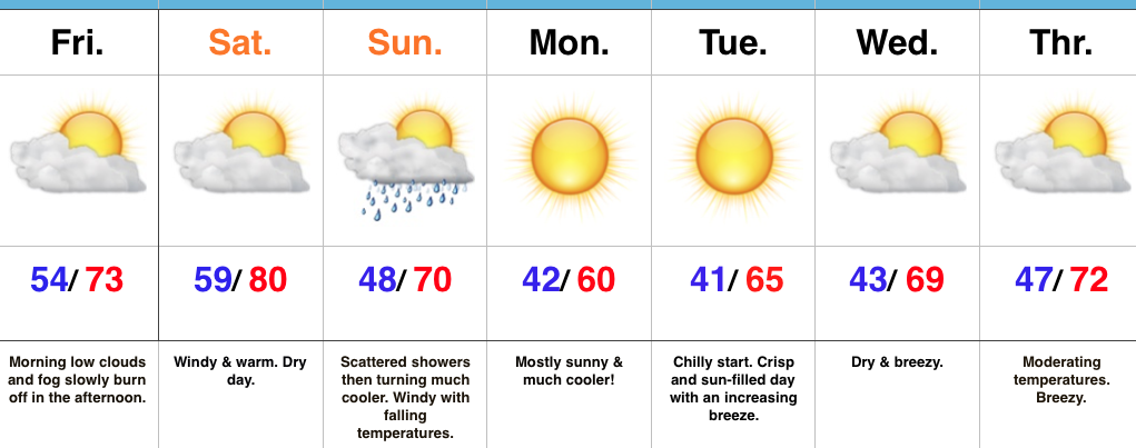
Falling Temperatures Today; Dry Weather Returns…
 Highlights:
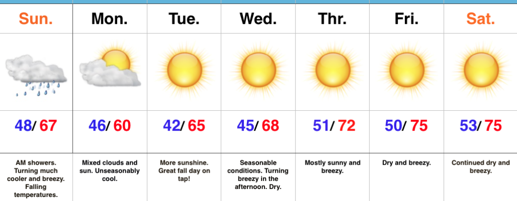
- Temperatures fall through the day
- Sunshine returns this week
- Pleasant stretch of weather ahead
Jackets And Sweaters Required By This Afternoon…A cold front will continue to march east this morning and this will push a broken band of showers east through the state. Rainfall amounts won’t be significant, but will be enough to be a nuisance on the way to church or brunch this morning. This afternoon, we’ll notice an increasingly gusty breeze and falling temperatures. While it’s mild this morning, it’ll feel much cooler as we progress through the afternoon and evening hours. Jackets and sweaters will be required!
High pressure will settle overhead for the upcoming week and this will lead to an extended period of dry, pleasant weather. Temperatures will moderate from seasonably cool early-week to unseasonably mild by late-week. As expected, the late September and early October warmth (particularly warm overnight lows) really stunted our fall foliage this year. That said, the cool, calm nights ahead this week will be sufficient enough to at least ignite some of the remaining leaves on trees for what should be a couple weeks of “decent” color ahead.
Longer term, there are big goings on behind the scenes that will help drive a dramatically different weather pattern to wrap up the month of October and head into November. Heads up to the parents out there, you may want to nudge the kiddos into picking a warm costume this Halloween…
Upcoming 7-Day Precipitation Forecast:
- Snowfall: 0.00″
- Rainfall: 0.10″ – 0.25″
Permanent link to this article: https://indywx.com/falling-temperatures-today-dry-weather-returns/
Oct 14
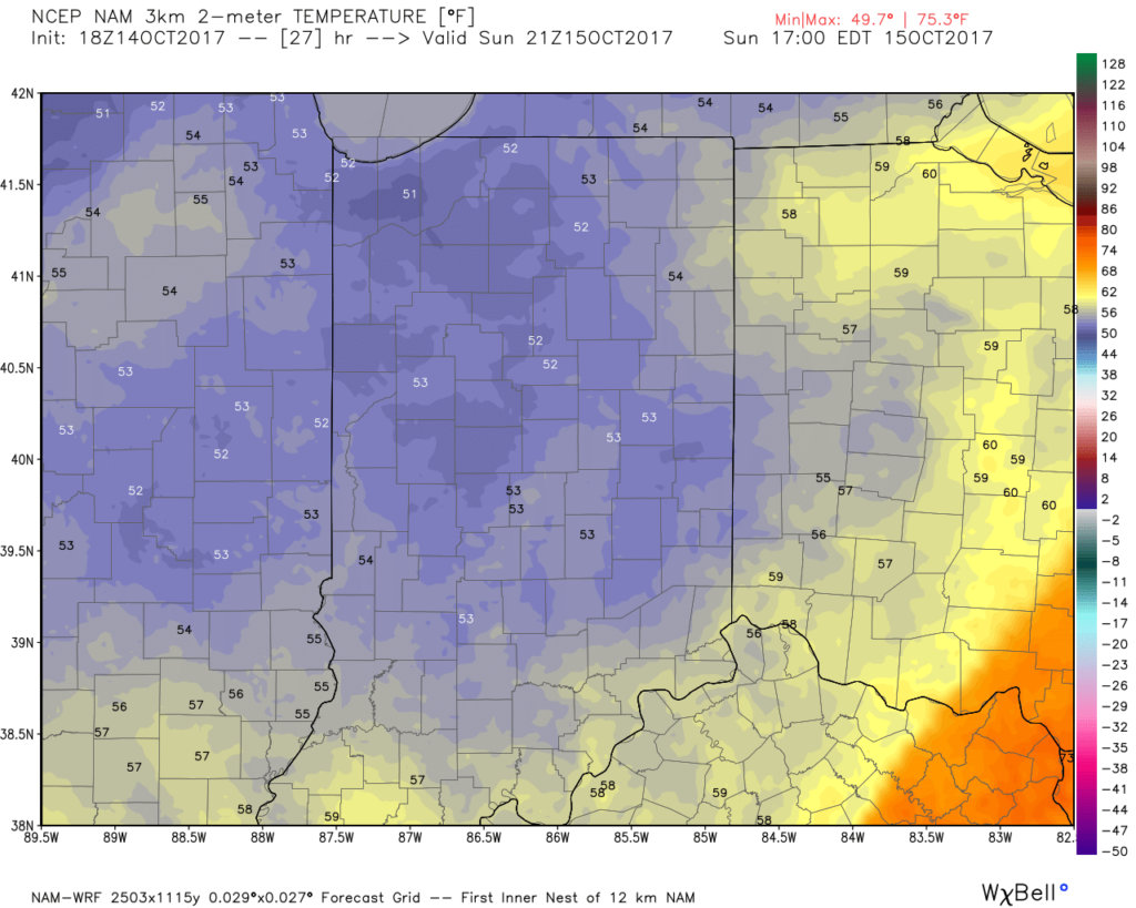
Sunday Morning Showers; Crashing Temperatures…
A cold front is on the move this evening. After a summer-like Saturday (that likely featured the last 80° day until next spring), MUCH cooler air will invade Sunday.
This evening, showers and thunderstorms, some of which have been strong-to-severe, are ongoing to our west and northwest. As the cold front draws closer, showers will push into central Indiana Sunday morning (mid-to-late morning). These showers and embedded thunder will be much weaker than what’s currently impacting our western neighbors. Here’s an idea what the radar may look like around 10a.
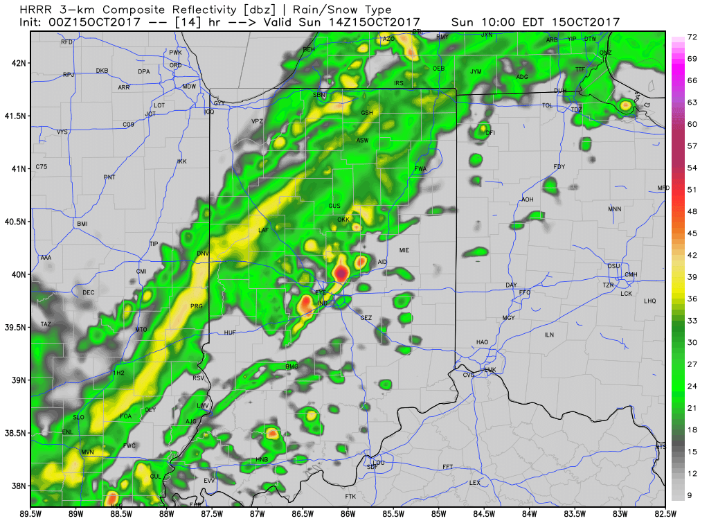
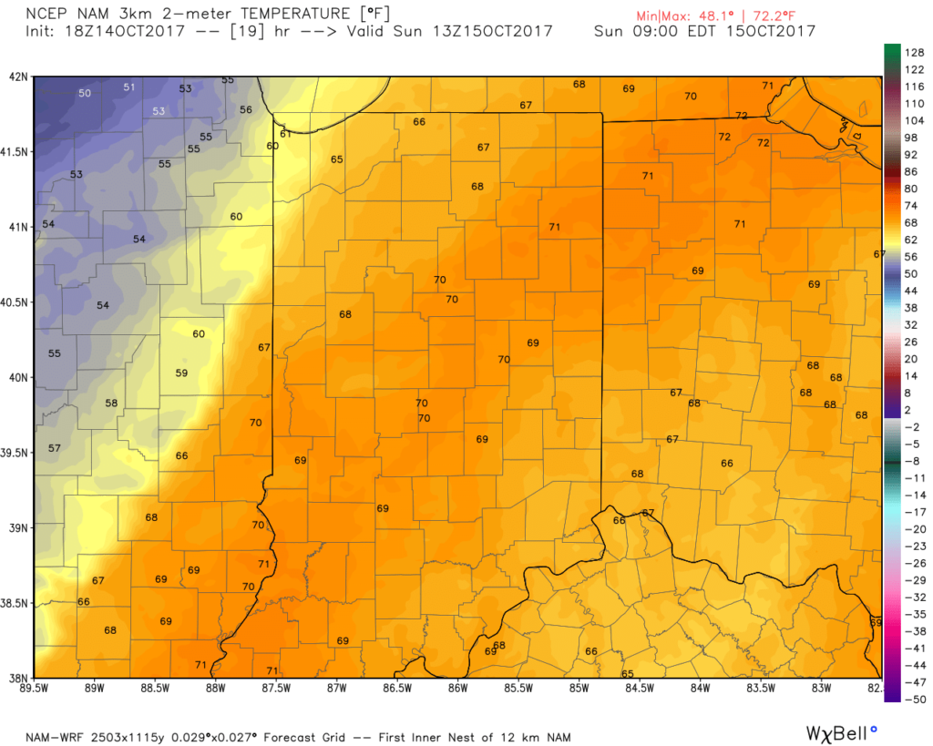
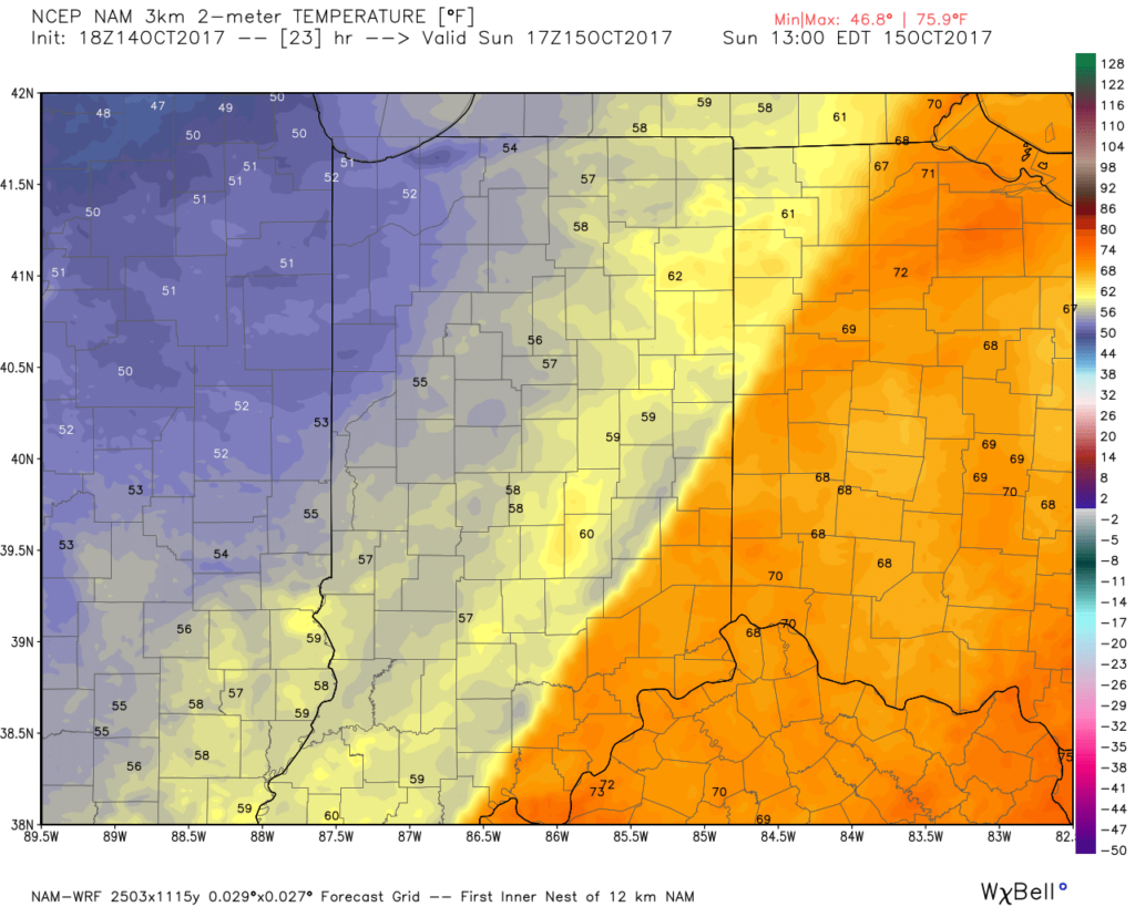
The bigger story Sunday will be the falling temperatures. Early risers will be greeted by temperatures around 70°, but these mild readings will transition to downright chilly conditions before sunset: 50s by lunch and 40s shortly after dark. Lows Monday and Tuesday mornings will fall into the 30s for outlying communities.
Permanent link to this article: https://indywx.com/sunday-morning-showers-crashing-temperatures/
Oct 12
Weekend Warmup Ahead Of The Coolest Air Of The Season…
 Highlights:
- Weekend Warmup
- Scattered showers Sunday morning
- Gusty winds and falling temperatures
Weekend Changes…Before we discuss our weekend weather, we should finally see the “doom and gloom” depart later this afternoon as enough of a southwest breeze and drier air helps scour out the low clouds, drizzle, and fog. Improvements will come slowly, but surely as we progress into the afternoon hours.
A delightful Saturday is dialed up, including what’s very likely to be our last 80° reading until next spring. Northern portions of the state will get in on some shower activity Saturday, but we’ll remain dry and windy here on the home front. As the cold front draws closer to the region, scattered showers and embedded thunder will blow into town Sunday morning. This won’t be a significant rain event and the much bigger deal will be the falling afternoon temperatures and gusty northwest breeze. You’ll need a jacket before the sun sets Sunday.
The cooler ending to the weekend is a harbinger of things to come as we open the new work week. In fact, temperatures will fall low enough to warrant a patchy frost risk for outlying areas away from the metro Monday and Tuesday mornings. Sun-filled skies and cool, crisp afternoons are on tap next week.
Upcoming 7-Day Precipitation Forecast:
- Snowfall: 0.00″
- Rainfall: 0.10″ – 0.25″
Permanent link to this article: https://indywx.com/weekend-warmup-ahead-of-the-coolest-air-of-the-season/
Oct 12
Colder Pattern Ahead To Close October; Open November?
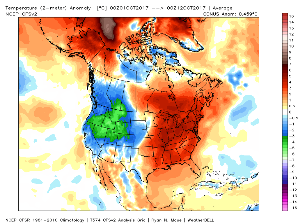
October, month-to-date, has been nothing short of a blow torch. Officially, IND is running +9° through the 11th.
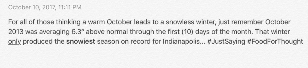
 In coffee shops and my travels around the great state of Indiana, I’ve overheard lots of talk centered on because October has been so warm, another lackluster snow season awaits. Let us remind you that the infamous snow season of ’13-’14 featured a very warm first half of October.
 The upcoming 7-10 days will feature more of a transitional period of weather that we’ve come to know and love around these parts. Warmth will spread northeast this weekend ahead of an approaching cold front (around 80° Saturday) before falling temperatures Sunday afternoon behind the frontal passage. The chilliest air so far this season will descend upon the region early next week. That said, the chill won’t hold and another surge of above normal warmth will spread northeast by the latter parts of next week.
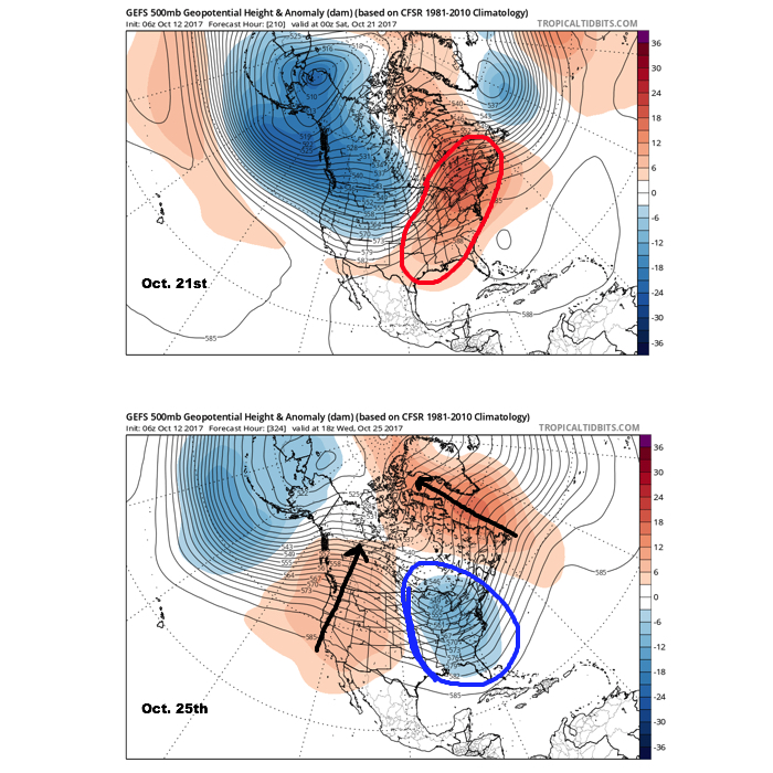
A more significant pattern change appears dialed up prior to Halloween and this is one that seems suited to lead to more prolonged and significant cold to wrap up the month and head on into November. Notice the evolution of things from October 21st to the 25th, courtesy of the GEFS off the fantastic tropicaltidbits.com. Other model data is in general agreement, leading to a rather high confidence level for this time period.
 It should also be noted that analog data and research also would lean heavily in the cold direction to wrap up October and these findings also favor a chilly November… More on that later! Speaking of later, an updated 7-day will be posted this evening. Make it a great day!
Permanent link to this article: https://indywx.com/colder-pattern-ahead-to-close-october-open-november/
