Wednesday Forecast: Getting To Be That Time Of Year!

Updated 10.15.13 @ 4:42p

Zionsville, IN Rain showers will continue pushing east of the region tonight and we should be rain-free Wednesday. We discuss what’s sure to be a busy, chilly forecast below!

Status-weather-clouds-iconWednesday: Partly cloudy; 50/ 61

Tuesday’s rain will be all, but a memory Wednesday with sunshine returning to your forecast. A north breeze will be in play, helping usher in cooler temperatures.


Status-weather-showers-day-iconThursday: Scattered showers; 0.10; 44/ 58

Some weak upper level energy will move across the state on Thursday and this could help spark a scattered shower.  We’re not looking at all day rains or significant rainfall by any means.  Besides the rain, the other big weather story Thursday will be the chilly air.  We’ll be far below the middle 60s, which is considered the normal high for this time of year.

Status-weather-clouds-iconFriday: Partly cloudy; 42/ 63

We’ll wrap up the work week with very pleasant autumn weather.  A secondary cold front and resurgent chilly air will be set to invade for the weekend, but we think the frontal passage holds off until Friday night. As of now, we forecast the front to come through dry.

Status-weather-clouds-iconSaturday: Partly cloudy; 40/ 54

Cool Canadian air will flow into the Hoosier state Saturday amidst chilly northerly breezes.  Winds may gust upwards of 20 MPH or so during the daytime Saturday.  You’ll certainly need that jacket or sweater as you head out to the fall festivals or the pumpkin patch!

Status-weather-clouds-iconSunday: Partly cloudy; 38/ 57

Weather conditions will be very similar to that of Saturday on Sunday.  Dry skies and chilly breezes will dominate our landscape.  Temperatures will remain below average.


Status-weather-showers-day-iconMonday: PM shower chance; 0.10; 39/ 64

Our winds will back around briefly to the southwest and allow just enough moisture northward to potentially lead to a broken band of showers to move through the region Monday evening/ early Tuesday ahead of our next cold front. Most of your daytime Monday will remain dry and rain-free.  This front is packing a punch in the temperature department and will likely produce the coldest air so far this fall season by the middle of next week, including the chance of the first official freeze for IND.

imagesTuesday: Mostly cloudy; 41/ 49

As of now, next Tuesday is shaping up to be a rather cloudy, raw day.  Strong cold air advection will be ongoing.  Gusty north winds will help usher in the coldest air so far this fall season.  In fact, highs likely will remain below 50 degrees next Tuesday with mostly cloudy skies and chilly north winds.

Permanent link to this article: https://indywx.com/2013/10/15/wednesday-forecast-getting-to-be-that-time-of-year/

Change On The Horizon…

So far, October 2013 is running well above normal in the temperature department: As shown above, the lower lakes and Ohio valley region has been the target for the biggest…

You must be logged in to view this content. Click Here to become a member of IndyWX.com for full access.  Already a member of IndyWx.com All-Access?  Log-in here.

Permanent link to this article: https://indywx.com/2013/10/15/change-on-the-horizon/

Monday Forecast: Heading Into A Colder Pattern

Updated 10.13.13 @ 5:33p

Zionsville, IN After enjoying a pleasant Sunday, we’re getting set for a busy time in the good ole forecast office this week.  This is just the beginning of a more active, colder, pattern that should carry us through the end of October…

Status-weather-clouds-iconMonday: Partly cloudy; 43/ 67

The new work week will dawn with pleasant skies and chilly conditions.  Some outlying areas could even dip into the 30s tonight/ early Monday.  We target the lower 40s officially for IND under fair skies. Dry conditions are on tap Monday with very pleasant temperatures.

Status-weather-showers-day-iconTuesday: Late Showers; 0.10; 52/ 72

Most of your Tuesday will remain rain-free, but we target our next cold front for a Tuesday night/ Wednesday arrival. As a result, we think a broken band of showers moves through the state Tuesday evening into Wednesday morning.  We’re not expecting heavy rain with this event and the bigger deal will be the drop in temperatures for mid and late week.

Status-weather-showers-day-iconWednesday: AM showers; 0.25; 48/ 61 (falling)

As mentioned above, our cold front will push east of the region Wednesday morning and usher in a wind shift to the northwest that’ll result in falling temperatures through the day. We think area thermometers are in the 50s by Wednesday afternoon along with a gusty northwest wind.

Status-weather-clouds-iconThursday: Mostly cloudy; 43/ 54

Cool will be the word Thursday with highs not making it out of the middle 50s.  As of now we think we remain dry Thursday with partly to mostly cloudy skies in place.  We’ll monitor for the chance of an instability-driven light shower chance, but these will likely be few and far between.

Status-weather-clouds-iconFriday: Partly cloudy; 42/ 60; Saturday: Mostly cloudy; 39/ 52

Partly cloudy and cool conditions will be with us as we wrap up the work week and head into the weekend. A cold front will blow through the state Friday evening, but it looks like moisture will be limited with this frontal passage. Again, similar, to that of the early week front, the bigger deal will be the drop in temperatures.

Status-weather-showers-day-iconSunday: Mostly cloudy with rain developing; 0.25; 43/ 54

Modeling is not in agreement with each other in regards to our next potential weather maker.  As a result, we’ll have to fine tune our Sunday forecast as we move forward.  If the next storm system is slower, then temperatures will be much cooler for overnight lows Saturday night and Sunday morning (into the 30s). As of now, we think clouds increase enough to prevent lows from falling much further than the lower 40s.  Otherwise, Sunday looks like a day where clouds lower and thicken through the day with rain not far behind.

Permanent link to this article: https://indywx.com/2013/10/13/monday-forecast-heading-into-a-colder-pattern/

Sunday Thoughts From The Gulf!

This post is coming to you from the beautiful sandy shores of the Florida panhandle. As a result, posts will be a bit erratic over the next week, or so,…

You must be logged in to view this content. Click Here to become a member of IndyWX.com for full access.  Already a member of IndyWx.com All-Access?  Log-in here.

Permanent link to this article: https://indywx.com/2013/10/13/sunday-thoughts-from-the-gulf/

Friday Forecast: Busier Times Ahead In The Good Ole Forecast Office!

Updated 10.11.13 @ 6:45a

Zionsville, IN I, like many of you, make sure to enjoy the last of the warm, sunny weather this time of year.  As veteran Hoosiers know, the months ahead present a cloudy, bitterly cold, and windy time of things.  Thankfully, we have another gorgeous day lined up to close the work week.  We discuss this and busier times ahead below!

Status-weather-clouds-iconFriday: Partly cloudy; 48/ 76

It’s only fitting that we close out the work week with the same type of weather we’ve enjoyed all week long- a cool start followed by beautiful weather conditions through the afternoon.  Get outside and spend some time soaking up the sunshine!

Status-weather-showers-day-iconSaturday: Mostly cloudy; scattered evening/ nighttime shower; 0.10″ or less; 50/ 76

Most of your daytime Saturday will provide pleasant weather to get some of those last minute chores taken care of.  We’ll notice an increase in our cloud cover followed by a broken line of showers (perhaps a rumble of thunder) rolling through the state from west to east.  We’re not looking at significant rainfall with this system.  In fact, we think most communities pick up less than one tenth of an inch of rain (if that).

Status-weather-clouds-iconSunday: Partly cloudy; 55/ 70 

While some of our extreme eastern counties may see an AM shower Sunday, most of the day will be rain-free and feature increasing sunshine.  It’ll be another pleasant day for outdoor activities.


Status-weather-clouds-iconMonday:  Partly cloudy; 45/ 69

High pressure and an associated northerly air flow will dominate our weather to begin the new work week. North breezes may gust upwards of 15 MPH Monday and this will help keep us cooler than the weekend. We’ll start the day quite chilly (middle 40s for most) before warming into the upper 60s.

Status-weather-showers-day-iconTuesday: Increasing cloudiness, PM shower; 0.10″; 54/ 73

While we have some timing issues to work out as we draw closer to the event (GFS is more progressive whereas the ECMWF is slower), we’ll go ahead and introduce shower chances to your forecast as early as Tuesday evening. Stay tuned as we fine tune things.

Status-weather-showers-scattered-iconWednesday: Rain; 0.50″; 49/ 64

As of now, we see a cold front moving through the region Wednesday. Ahead of the front, showers and possibly a thunderstorm will blow through the region.  Our winds will shift to the northwest Wednesday night/ Thursday, helping drive the coldest air so far this season into the Hoosier state Wednesday night and Thursday.

Status-weather-showers-scattered-iconThursday:  Rain; 0.50″; 44/ 57

Again, as we posted above, timing is everything with our mid to late week cold front.  Overnight model data places a heavier corridor of rain through central Indiana mid week- potentially as much as 1″-1.25″ over the two day period.

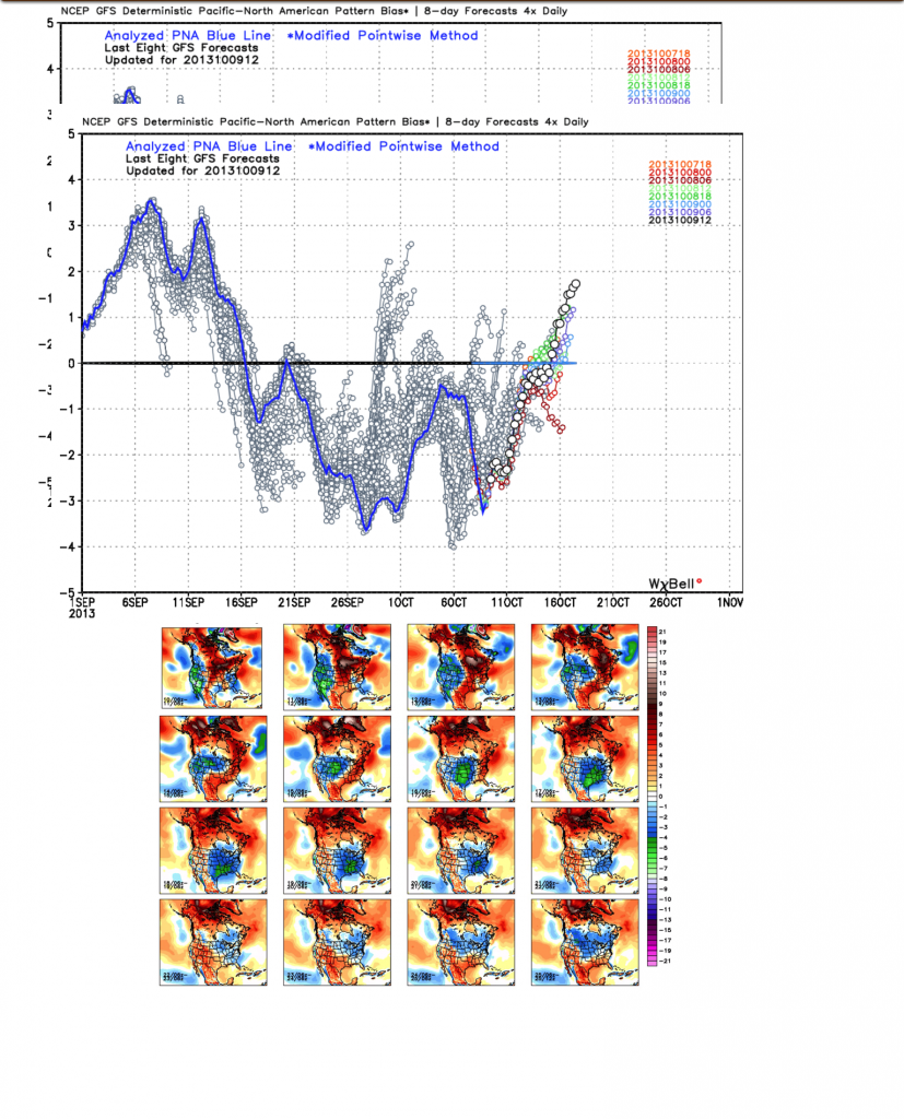
We also want to continue pointing out that with the PNA shifting back into the  positive, the stage is set for chilly air to hang around the region with more “staying power” as we move through October’s second half.  We’ve covered this in posts below and will continue to go over things as we move forward…  It’s time to certainly pull out those coats! 🙂

Permanent link to this article: https://indywx.com/2013/10/10/friday-forecast-busier-times-ahead-in-the-good-ole-forecast-office/

Changes Brewing?

After an unseasonably cool summer, the pattern flipped to a warmer regime during the month of September.  That same warm pattern continues presently, but are changes brewing?

We note the PNA (Pacific North American pattern) is trending positive and this could help promote more of a sustained trough and associated cooler than normal pattern to wrap up October.  Would it be enough to offset the very warm first half of October?  Too early to tell.  However, I will say that with the PNA trending positive, it does suggest we’ll be looking at more sustained chilly conditions, as opposed to the “in and out” flirtations of cool air as of late.

The GEFS suggests a trough sets up shop across the eastern part of the country for the back half of October.

IMG_0889

Permanent link to this article: https://indywx.com/2013/10/10/changes-brewing/

Thursday Forecast: Beautiful Weather Continues (For Now)…

Updated 10.09.13 @ 5:00p

Zionsville, IN Our stretch of beautiful early fall weather will continue as we wrap up the work week and head into the weekend. Latest model runs are looking less and less impressive on rain chances Sunday (very light amounts), but we do have more significant weather to discuss in the longer term…

Status-weather-clouds-iconThursday through Saturday: Mostly sunny to partly cloudy; upper 40s, middle 70s Thursday and Friday and upper 70s Saturday.

High pressure will remain in firm control of our weather pattern to wrap up the work week and head into another weekend. This means our “uneventful” weather will remain with mostly sunny skies Thursday and Friday, giving way to partly cloudy conditions Saturday.  While overnight lows will remain pleasantly cool, daytime highs will continue to moderate, eventually reaching the upper 70s by Saturday.

Status-weather-showers-day-iconSunday: Scattered shower; 0.10″; 58/ 74

Latest model runs continue to look less and less impressive in terms of potential rainfall Sunday.  While a broken line of light showers will press their way through the region, we’re certainly not looking at any sort of significant rainfall.  Simply put, the moisture return just isn’t that significant ahead of the advancing cold front.  Most of your Sunday will remain dry with just a quick scattered shower expected at this point.

Status-weather-clouds-iconMonday: Partly cloudy; 54/ 70

There’s currently a pretty big spread in forecast temperatures to kick off the new work week.  Case in point, the European model suggests we’re looking at a dry day with sunshine, helping to push the thermometer into the lower 70s.  The GFS says it’ll have “none of that” as it keeps us in the lower 60s with lots of clouds and showers around.  For now, we’ll side with more of the European solution, with a mainly dry day and highs reaching the 70 degree mark.  Stay tuned.

Status-weather-showers-day-iconTuesday: Mostly cloudy; scattered shower; 0.10″; 55/ 72

Our next storm system will advance towards the region by the middle of next week. While we still have to work out timing and track involved with this system, we think southerly winds transport enough low level moisture northward to help spark a scattered shower as early as Tuesday afternoon.

Status-weather-storm-night-iconWednesday: Showers and T-storms; 0.50″, 51/ 62

At this distance, it appears as if the primary energy source (surface low) will track too far north and west of the region to result in significant severe weather, but we’ll still expect showers and thunderstorms to become likely Wednesday, especially directly related to the frontal passage.  Model data suggests heaviest rainfall totals fall across northern portions of the state, but with this being a week out, we’ll continue to monitor for any potential shift in the track of the low.

A MUCH colder air mass will pour into the region late next week, resulting in the coldest temperatures so far this fall season…

Permanent link to this article: https://indywx.com/2013/10/09/thursday-forecast-beautiful-weather-continues-for-now/

Wednesday Evening Forecast Update


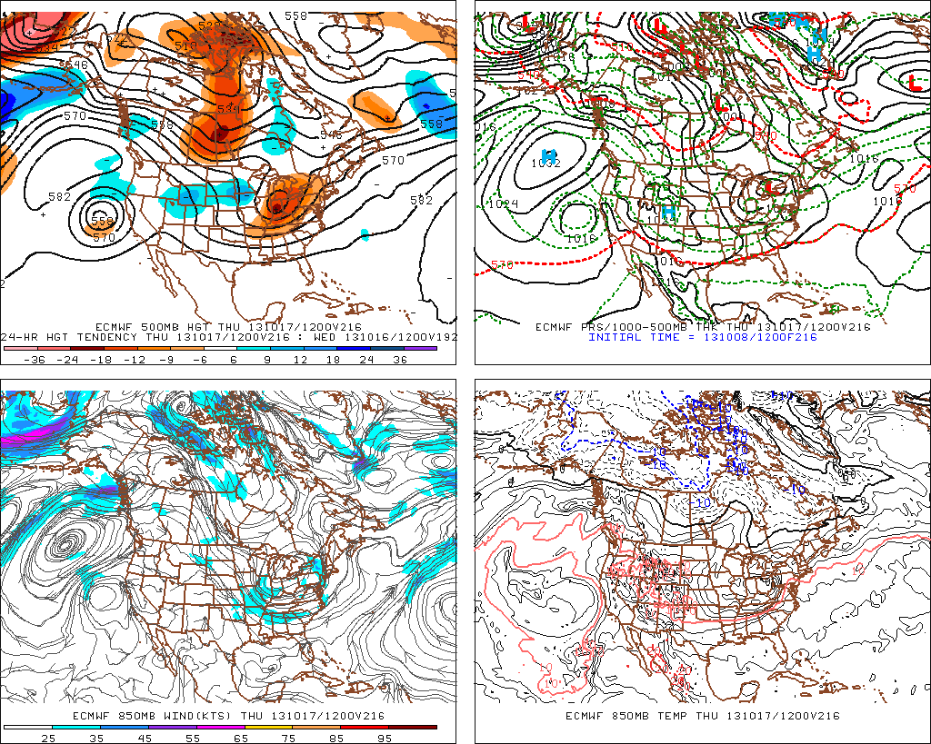
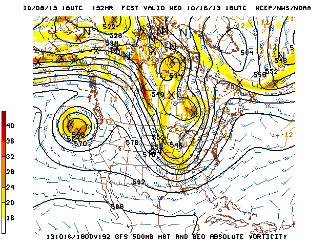
Forecast models continue to hint at the potential of our next significant storm system slated for a mid month arrival.  Latest data, hot off the press, remains in general agreement on the way things evolve, but details on timing and any heavy rain/ severe threat will have to be fine tuned as we move forward.

f216

gfs_namer_192_500_vort_ht_s

Permanent link to this article: https://indywx.com/2013/10/08/wednesday-evening-forecast-update/

Tuesday Forecast: Sun-Filled Autumn Stretch Ahead!

Updated 10.07.13 @ 6:41p

Zionsville, IN After a weekend featuring plentiful rain and embedded thunderstorms, it was nice to see the return of the sunshine to kick off the new work week.  For those craving a more fall-like feel to the air, well you have your wish with low humidity, warm days, and cool nights in store this week.

Status-weather-clear-iconTuesday through Friday: Mostly sunny; Lows in the lower 40s early in the period, rising to the upper 40s by Friday morning. Highs in the upper 60s Tuesday and lower to middle 70s Wednesday through Friday.

High pressure will remain in firm control of our weather as we progress through the rest of the work week.  After a cool start to the period (some outlying areas will dip into the 30s tonight), temperatures will moderate through the remainder of the week, getting back above normal by mid week.  Mostly sunny skies will prevail this week, giving us a much needed chance to dry out after the heavy weekend rainfall.

Status-weather-clouds-iconSaturday: Partly cloudy; 52/ 76

Our next storm system will begin to approach the region for the second half of the weekend. The way we see things now is that we should get a dry first half of the weekend in with just some increasing cloudiness during the afternoon.  It’ll be a nice Saturday with above normal temperatures and dry conditions.

Status-weather-showers-scattered-iconSunday: Showers; 0.2559/ 70

A cold front will pass through the state Sunday and feature scattered to numerous showers as it crosses the region.  We’re not looking at any sort of heavy rain or severe weather with this frontal passage.


Status-weather-clouds-iconMonday: Partly cloudy; 56/ 69

Similar to that of today, we should see the sunshine return to kick off the new work week, after a gloomy end to the weekend.  Temperatures don’t appear to be particularly cool behind Sunday’s frontal passage, but we’ll shave a couple of degrees off the thermometer next Monday.

Permanent link to this article: https://indywx.com/2013/10/07/tuesday-forecast-sun-filled-autumn-stretch-ahead/

Sunday Afternoon Rambles…

Rain was plentiful over the region over the past 48 hours.  While widespread 2″ rainfall was common for all of central Indiana, the heaviest rainfall fell across southern and eastern Indiana.

Here are a couple of illustrations of the rainfall totals.  The first image is storm total rainfall from the past 24 hours. Note the heavy, 4″ type rains over southern and eastern Indiana. The second image is off the awesome Weatherbell model site and shows the heavy rainfall event over Indiana that unfolded on a bigger scale.  Needless to say, the short term drought concerns that we were dealing with August and September have been erased.

1379925_643932488960824_62568978_n


rtma_precip_48

Temperatures are running MUCH cooler over the region today and we also note a drier, more fall-like, air mass building into the region.  A couple of other items- it’s easy to see where the cold front is currently located (as of this post) as many in Ohio are still dealing with warm, humid conditions.  Additionally, the cold core upper level low remains to our west and will rotate over our region Monday.  This will lead to an unseasonably cool day with mostly cloudy skies and the potential of a scattered shower.

rtma_glus

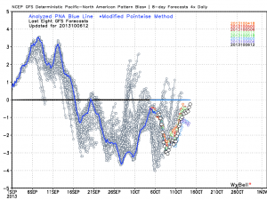
As we move forward, despite the cooler air to welcome in the new work week, we remain in a warmer than average pattern overall.  The PNA continues to dominate the pattern and until this goes positive, don’t look for any sort of sustained cool weather across the eastern US.

gfs_pna_bias


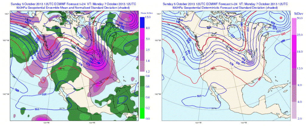
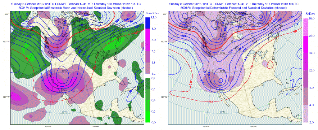
The European operational and ensemble show the current trough and associated cool air retreating and allowing a warmer southwesterly air flow to build in this week.

Monday

Geopotential32at32500hPa_North32America_24


Thursday

Geopotential32at32500hPa_North32America_96After a quiet time ahead (and much needed to dry out), our next significant storm system appears to arrive around mid month.  Both the GFS and European model are in agreement with this idea.  Does another potential significant rain maker and associated severe weather event lie ahead mid month?  Possibly.

Here’s a look at the upper air pattern out at Day 10 off the European model.  We note another significant storm system ejecting out into the Plains states, most likely after dumping another impressive early autumn snow on the central and northern Rockies.

ecm_z500_anom_noram_11

The GFS idea is something similar to that of the European, suggesting confidence is relatively high, at least from this distance.

gfs_z500_sig_noram_37

All of that said, we’re still in a “transient” pattern as the next big storm is shown crashing onshore along the west coast by both models.  We shouldn’t be surprised by a “transient” pattern this time of year. It’s October, after all- a month notorious for many swings on the thermometer.

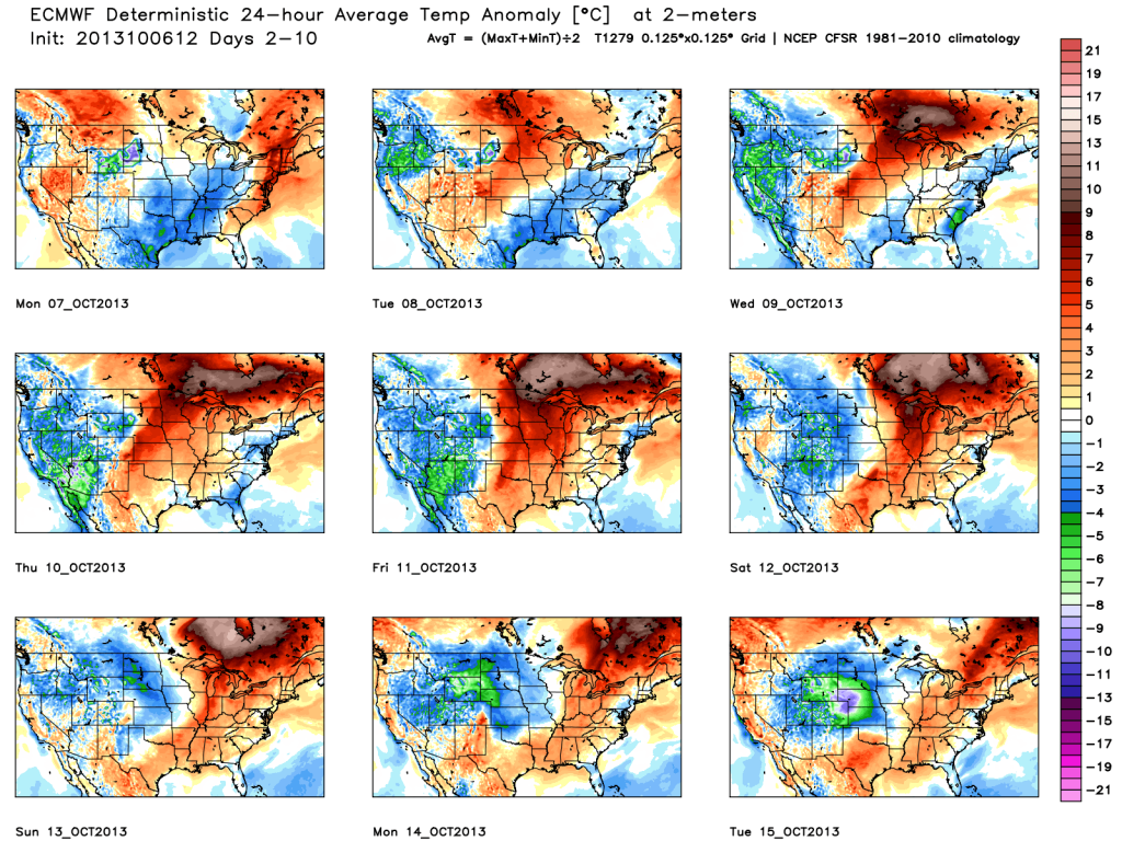
We’ll close with a look at the European’s temperatures anomalies over the course of the next 10 days.  Note the chill of early week erased with above normal warmth for the majority of the period. Also, pay attention to the unseasonable chill coming off the Rockies and into the Plains towards the end of the period below.  This is associated with the mid month storm.

tavg_anom_ecmwf_conus_1

Permanent link to this article: https://indywx.com/2013/10/06/sunday-afternoon-rambles/

IndyWx.com