Perhaps you’ve heard folks discuss the “typhoon rule” over the past few weeks. What I despise is when people take credit for certain ideas without giving credit where credit is…
You must be logged in to view this content. Click Here to become a member of IndyWX.com for full access. Already a member of IndyWx.com All-Access? Log-in here.
Tranquil Autumn Weather…A prolonged stretch of dry weather is on tap as we open a new work week. While we’ll start the week off on an unseasonably cool note, temperatures will moderate back to seasonal levels by mid week and above normal levels heading into next weekend. The next chance of rain won’t arrive until late Sunday and even that is not a good chance (not worth even mentioning in the forecast above just yet).
For all of you fall foliage fans out there, the combination of early cool air through September combined with the extended stretch of dry, sunny days has led to an early start to the color show. With continued tranquil weather expected, anticipate ideal conditions for continued increased color in the days and weeks ahead.
Upcoming 7-Day Precipitation Forecast:
7-Day Rainfall Forecast: 0.00″
7-Day Snowfall Forecast: 0.00″
We enjoyed a colorful sunset last night off the IndyWx.com observation deck. 🙂
A secondary cold front is moving into central Indiana this afternoon with clouds, gusty northerly breezes, and fresh cool air. Speaking of cool, September, so far, has been cooler and…
You must be logged in to view this content. Click Here to become a member of IndyWX.com for full access. Already a member of IndyWx.com All-Access? Log-in here.
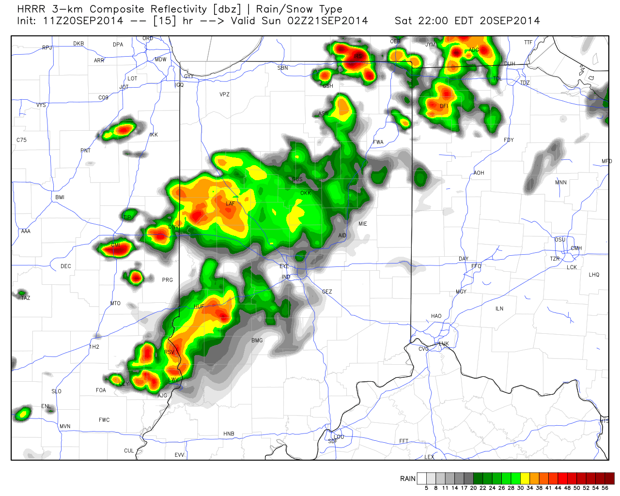
Stormy Night Ahead For Some…Most of today will feature plentiful sunshine and warm southwest breezes. While we’ll enjoy a mostly dry day time, storms will ignite to our north and a couple of these could reach severe levels across northern Indiana later this evening. These storms will sink south into central Indiana during the late evening/ overnight period. While a strong to severe storm is possible across central Indiana, the overall trend will be a weakening one as the storms shift south.
We’ll maintain a mention of a shower Sunday (most of the day will remain dry), otherwise look for a cooler day as winds shift to the north behind our cold front.
Cool Start; Warm Finish…The work week will get off to an unseasonably cool start as highs only reach the middle 60s Monday. The week ahead will be another dry one and temperatures will slowly rebound through the week, as well. Highs by Friday will reach the 80 degree mark, or above, for many.
Speaking longer term, the overall October pattern is one that looks warmer than normal to us here at IndyWx.com, but more on that in the days ahead.
Upcoming 7-Day Precipitation Forecast:
7-Day Rainfall Forecast: 0.25″ – 0.50″
7-Day Snowfall Forecast: 0.00″
John Salewicz caught this beautiful sunset shot Friday evening in Zionsville. Thanks, John!
While storms will likely be in a weakened state dropping into central Indiana, a couple strong storms are still possible late tonight.
Dry skies and ideal weather conditions can be expected as you venture out to support your favorite high school football team this evening. High pressure will remain anchored over our…
You must be logged in to view this content. Click Here to become a member of IndyWX.com for full access. Already a member of IndyWx.com All-Access? Log-in here.