Category: Wintry Mix

Friday Morning Rambles…

I. Bitter Cold: We’re adding another morning below zero to an already impressive (and growing) list of frigid lows this winter.  Take a look at these morning lows in the…

You must be logged in to view this content. Click Here to become a member of IndyWX.com for full access.  Already a member of IndyWx.com All-Access?  Log-in here.

Permanent link to this article: https://indywx.com/friday-morning-rambles-4/

VIDEO: Wintry Threats On Deck & Looking Deeper Into January…

You must be logged in to view this content. Click Here to become a member of IndyWX.com for full access.  Already a member of IndyWx.com All-Access?  Log-in here.

Permanent link to this article: https://indywx.com/video-wintry-threats-on-deck-looking-deeper-into-january/

Frigid Times; Watching Sunday…

Highlights:

  • Fresh batch of arctic air served up
  • Watching Sunday
  • Moderating next week

Brutal Cold Continues…A fresh batch of arctic air arrived into the Hoosier state last night.  This will set the stage for an absolutely frigid close to the week.  Wind chill values will periodically reach dangerous levels between now and Saturday morning.  Additionally, we’ll add a few more mornings to the sub-zero club in what’s already an impressive list this winter.

Attention remains on a developing storm system that will impact our region Sunday into early Monday.  We forecast a lowering and thickening cloud deck to arrive overnight Saturday into Sunday morning, followed by a wintry mix Sunday afternoon and evening.  Messy wintry precipitation should continue into early Monday before precipitation departs to our east.  Data, overall, has trended colder over the past 24 hours and would lead to more impact from snow and less ice.  Stay tuned.

Drier times return early next week along with moderating conditions ahead of the next storm system that will approach late next week.

Upcoming 7-Day Precipitation Forecast:

  • Snowfall: 1″ to 3″
  • Rainfall: 0.00″

Permanent link to this article: https://indywx.com/frigid-times-watching-sunday/

Unseasonably Pleasant Open To The Weekend…

Highlights:

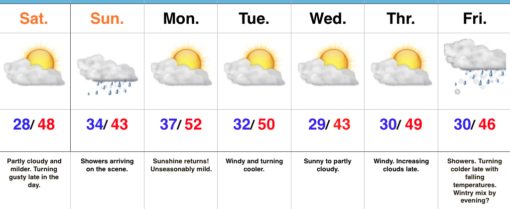
  • “Can’t beat it” weather for mid-December
  • Raw second half of the weekend
  • Changes loom

Great Open To The Weekend…High pressure and a relatively mild southwest flow will help boost temperatures to near 50° Saturday afternoon, complete with plentiful sunshine.  We will note an increasingly gusty southwest breeze late in the day.

The second half of the weekend will feature an increasingly wet period, along with a “raw” feel.  Rainfall amounts won’t be particularly impressive, but rain gear will be required on the way out to church Sunday morning.

High pressure will quickly build back in thereafter and remain in control of our work week weather.  A nice stretch of pleasant conditions (by mid-December standards) will prevail, including plentiful sunshine.  Enjoy it as big changes loom.

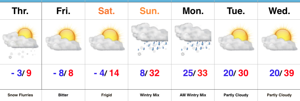
The all-important Christmas-New Years period is growing ever closer and data continues to suggest we should gear up for busy times in the forecast office.  An active pattern looms, including one that will trend progressively colder.

Upcoming 7-Day Precipitation Forecast:

  • Snowfall: 0.00″
  • Rainfall: 0.10″ – 0.25″

Permanent link to this article: https://indywx.com/unseasonably-pleasant-open-to-the-weekend/

Gloomy St. Patrick’s Day Gives Way To A Brighter Weekend…

Highlights:

  • Wet, raw St. Patrick’s Day
  • Brighter weekend ahead
  • Shower chances return next week

Weekend Improvements Ahead…Today won’t be the classic “chamber of commerce” weather day across central Indiana.  A brief wintry mix impacted central and eastern portions of the state earlier this morning and will give way to “showery” weather with blustery conditions and an overall raw feel.  It won’t rain the entire day, but plan on packing the wet weather gear as you venture out to your March Madness and St. Patrick’s Day parties.  Stay safe out there!

Drier times will return for the weekend as high pressure slowly builds overhead.  Saturday will feature a couple of showers- especially across eastern portions of the state through the early afternoon.  However, brighter conditions will develop late in the day and by Sunday, mostly sunny skies will return.  Along with the increasing Sunday sunshine, temperatures will top 50° for the first time since March 8th.

Unfortunately the sunshine won’t last into the early stages of the work week as moisture returns and showers follow Monday into Tuesday.  We’ll turn briefly colder Wednesday before a moist southerly flow returns Thursday with another round of showers.

Upcoming 7-Day Precipitation Forecast:

  • Snowfall: 0.00″
  • Rainfall: 0.50″ – 1.00″

Permanent link to this article: https://indywx.com/gloomy-st-patricks-day-gives-way-to-a-brighter-weekend/