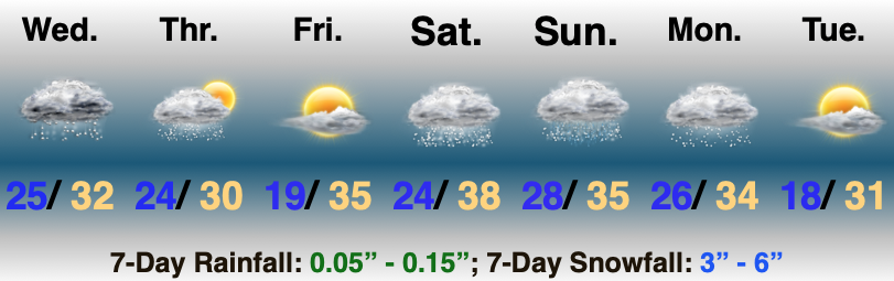
Multiple Snow Makers; Cold Grows More Bitter…

Updated 02.08.21 @ 8:32a

Most of the daytime today will only feature light snow, but don’t let that fool you. With such a cold, arctic airmass in place, even the “light” snow is creating travel issues in spots. Take it slow out there, friends.

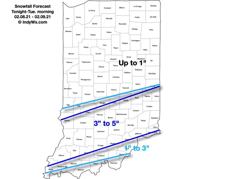
A new piece of upper level energy will streak across the region tonight and help snow to become more organized in aerial coverage. A narrow, but efficient band of steadier snow is expected to get going across south-central Indiana around, or just after, sunset. It’s within this snow where we expect several inches of snow to accumulate tonight and early Tuesday morning.
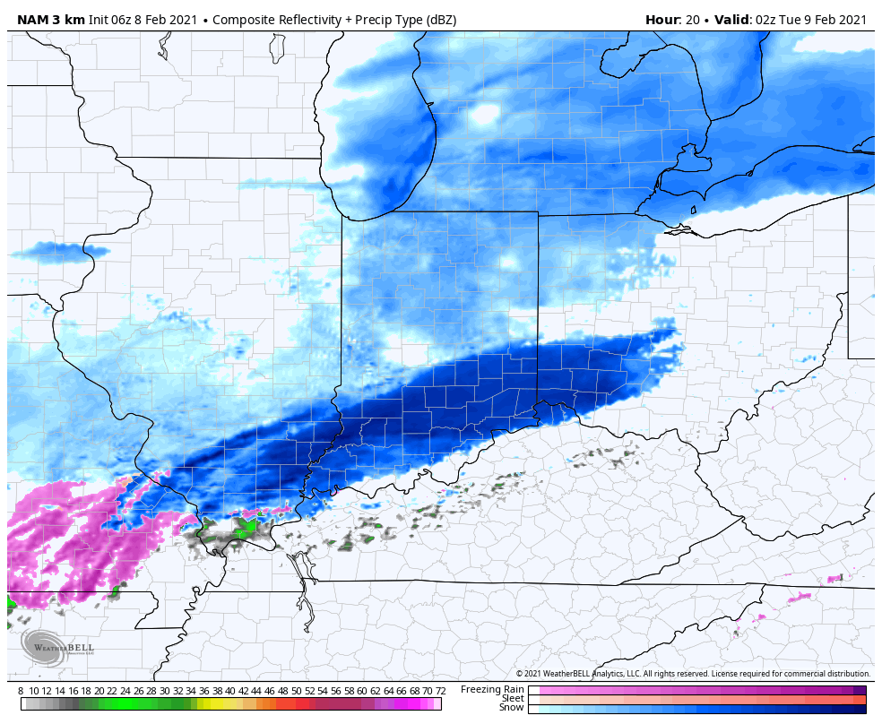
Snow will become moderate to heavy at times across south-central IN tonight.

Most of the steady snow will exit to the east before sunrise Tuesday. We’ll then be left with periods of flurries and light snow through the remainder of the day.

Here’s our snowfall forecast with tonight’s system:
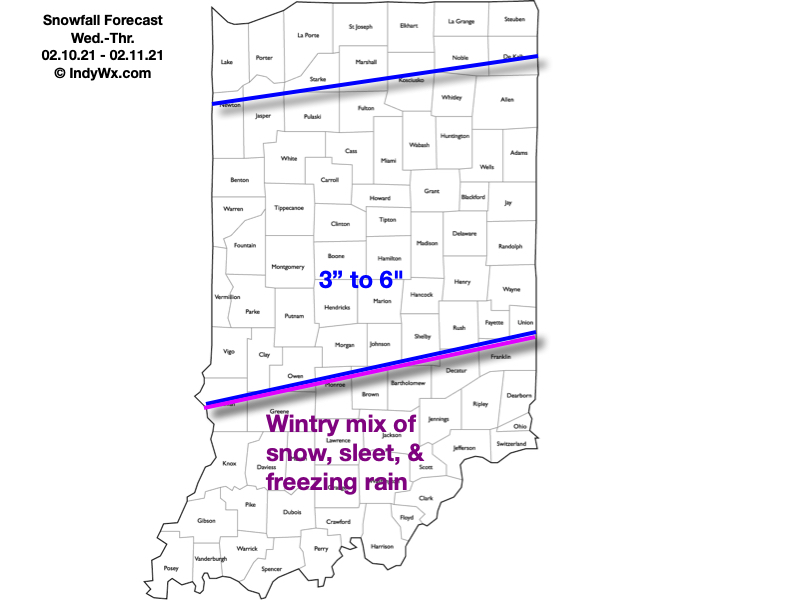
Attention will then shift to a “juicier” midweek storm system. An arctic boundary will remain draped to our south while a surface wave rides northeast along the stalled front. This will allow more widespread, heavier precipitation to push into the region (from southwest to northeast) through the morning Wednesday. For a time, moderate to heavy precipitation rates are expected Wednesday evening into Wednesday night. The early call on this system continues to be for an all snow event across central Indiana (where we think 3″ to 6″ of fresh snow is a good bet) with more of a wintry mix of snow, sleet, and freezing rain across southern portions of the state as warmer air aloft gets pulled north. Unfortunately, I think even southern portions of the state remain cold at the surface, continuing the threat of an icy glaze vs. a plain ole rain.
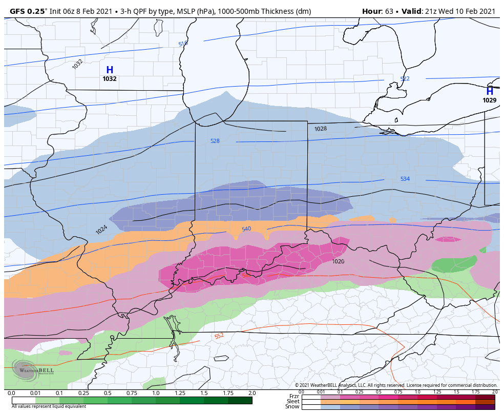
Widespread wintry precipitation will overspread the region Wednesday.

Here’s our snowfall forecast for Wednesday and Thursday:
As the snow continues to add up, concern will mount around the issues that will likely come from a blowing and drifting perspective- especially as a fresh arctic intrusion arrives late week. If that wasn’t enough, additional “fun and games” are on the table for the upcoming weekend, followed by the coldest air so far this season (and in some cases in a couple of years).

Stay tuned…
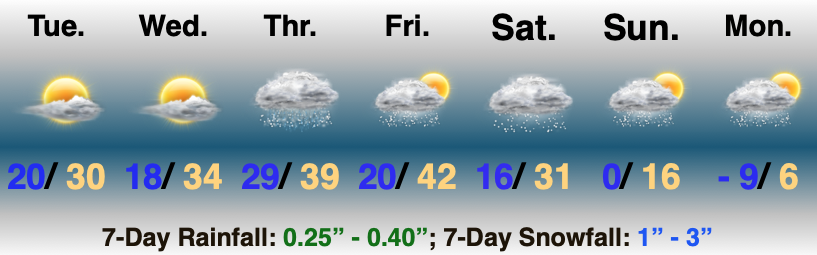
VIDEO: Tracking Multiple Winter Weather Makers Over The Upcoming 7-10 Days…

Updated 02.05.21 @ 4:19p

You must be logged in to view this content. Click Here to become a member of IndyWX.com for full access.  Already a member of IndyWx.com All-Access?  Log-in here.

02.01.21 Weather Bulletin: The Arctic Hounds Come Calling…

Updated 02.01.21 @ 6:34p

Bottom Drops Out Early Next Week…Brief high pressure will build overhead through the next 24 to 48 hours and supply a return of sunshine. We may still have a few light flurries around through the early afternoon Tuesday, but the story over the next couple of days will be improving weather, albeit still chilly.

Our next storm system will approach Wednesday night and Thursday in the form of a cold front. Precipitation should arrive Thursday morning as a cold rain (might start as a brief wintry mix, but this shouldn’t be a big deal). The cold front will then sweep through the state Friday morning. Highs will likely take place during the predawn hours with falling temperatures through the day. Any lingering morning precipitation should exit stage right relatively quickly.

Things become much more interesting over the weekend as a couple of arctic fronts sweep across the region. The first front will feature vigorous upper level energy and will likely result in a period of snow. The second front will really drop the “arctic hammer” and not only lead to the coldest air we’ve seen in quite some time, but a continuation of snow chances into early next week.

We’ll keep a close eye on the development of things for the weekend. With arctic air getting involved, it’ll likely maximize any available moisture and a couple of seemingly rather “harmless” snow events could turn into over-achievers as we grow closer. I’d keep close tabs on the weekend forecast.

Bitter air will pour into the region early next week, including dangerously cold wind chill values. Those with ag/ livestock interests should be prepared to make adjustments for the severe cold.

01.27.21 Weather Bulletin: Snow Builds In This Afternoon For The Southern Half Of The State; Keeping Close Eyes On The Weekend…

Updated 01.27.21 @ 7:51a

No Rest For The Weary…A fast moving area of low pressure will scoot east this afternoon and evening. This will spread a swath of light to moderate snow across the southern half of the state in the 1p (west) to midnight (exiting southeastern portions of the state) window. While still primarily a light event, models have “beefed up” snow amounts ever so slightly with this system over the past 24 hours. Our snowfall forecast for system #1 can be found below.

Colder air will pour in for all during the overnight and should be just enough to kick up some lake-generated scattered snow shower activity into Thursday morning.

Weak high pressure will then build in and supply a sunny close to the work week. You enjoy the sun and briefly quieter weather and let us worry about the weekend!

Speaking of the weekend, this is the period that continues to look increasingly likely to produce the most impactful winter storm of the season for our immediate area. We forecast early sun to quickly give way to a lowering and thickening cloud canopy Saturday (the sky will have the looks of a snow storm brewing by lunch for most). Precipitation will then overspread the region from southwest to northeast as we progress through the afternoon. The potential is there for a heavy wet snow thump Saturday PM before precipitation transitions to a wintry mix as low pressure scoot by just to our south. Before that transition, “several” inches of wet snow is looking increasingly likely. As colder air wraps back around into the region, wrap-around moisture will fall as light snow and snow showers into early next week.