Category: Winter Storm

Saturday Early Afternoon Thoughts And Snowfall Forecast For Sunday And Tuesday Night – Thursday…

Updated 01.21.23 @ 1:54p

The first in a series of accumulating snow events will move in Sunday morning followed by another (heavier) event Tuesday night and Wednesday, with accumulating snow continuing late into the upcoming work week. In short, we don’t have any changes from this morning’s video discussion, but did want to add some specific snow numbers behind our ideas. First thing first and that’s Sunday:

Mostly cloudy skies this evening will lower and thicken during the overnight and snow is expected to break out across western IN between 3a and 4a, reaching the city, itself, between 5a and 6a. Snow should reach peak intensity between 7a and 10a in the city before the steadiest snow pushes east. Lighter snow is expected to continue into the early to mid afternoon hours. Despite marginally cold air and relatively warm surfaces for the time of the year, slick roadways are expected Sunday morning as the snow increases in intensity. Plowing and salting will likely be required before the snow intensity diminishes from west to east Sunday afternoon.

6a forecast radar Sunday
8a forecast radar Sunday
10a forecast radar Sunday
12p forecast radar Sunday

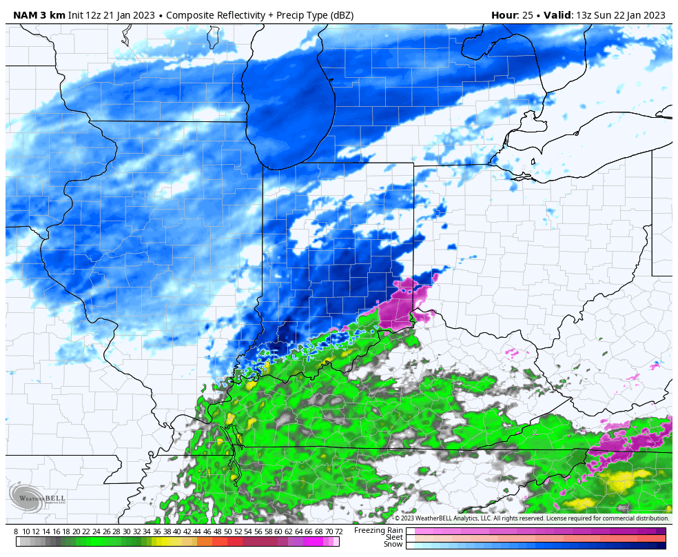
Temperatures will be in the lower 30s while the majority of the snow falls so this will be a heavier, wetter snow than the champagne powder we dealt with pre-Christmas. Also a friendly reminder to discredit any sources trying to show you a kuchera snowfall map with this event (or the next event for that matter). These will both likely be much closer, if not even a little less, than 10:1 ratio type snow events- perfect for a snowball fight or building a snowman!

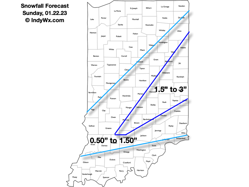
Sunday’s snowfall forecast:

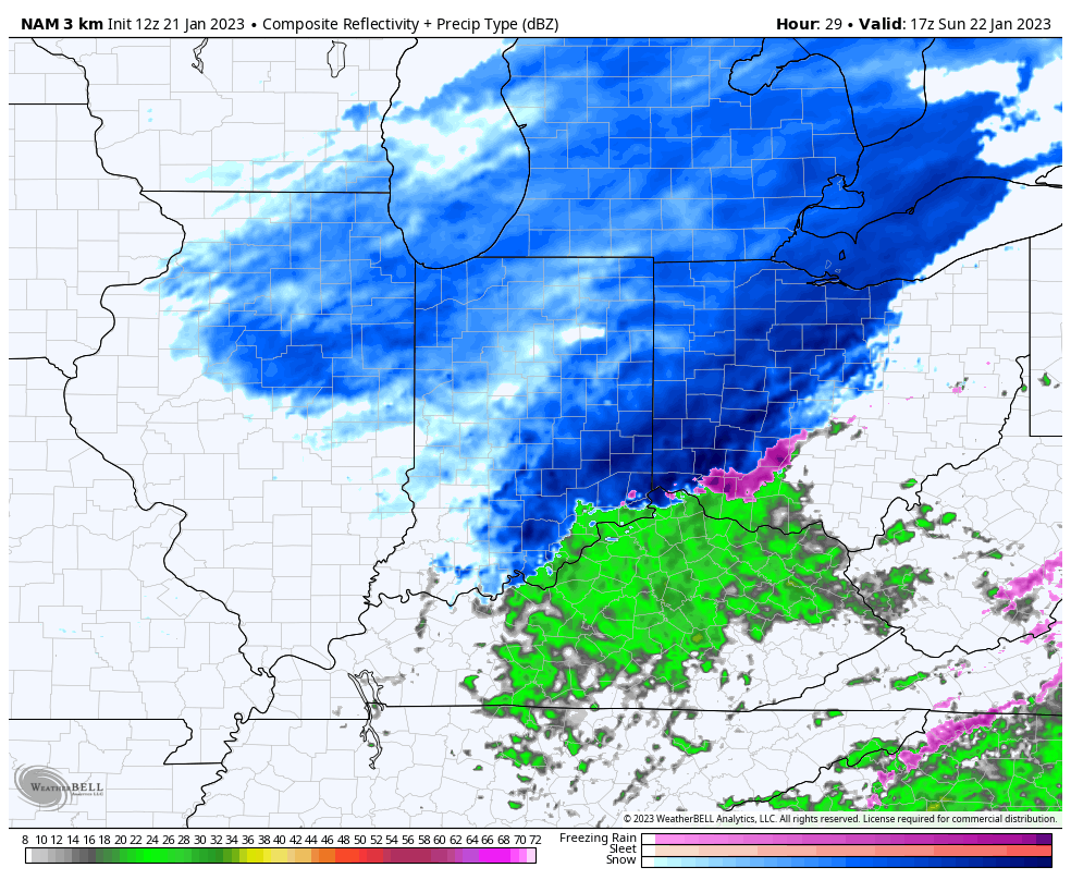
A few lingering early flurries are possible Monday, otherwise the bulk of the daytime Monday and Tuesday should be precipitation free. We may even see some sun work back into the picture during this timeframe. As we push into Tuesday evening, clouds will once again lower and thicken and give way to snow lifting in from the southwest after 11p to midnight.

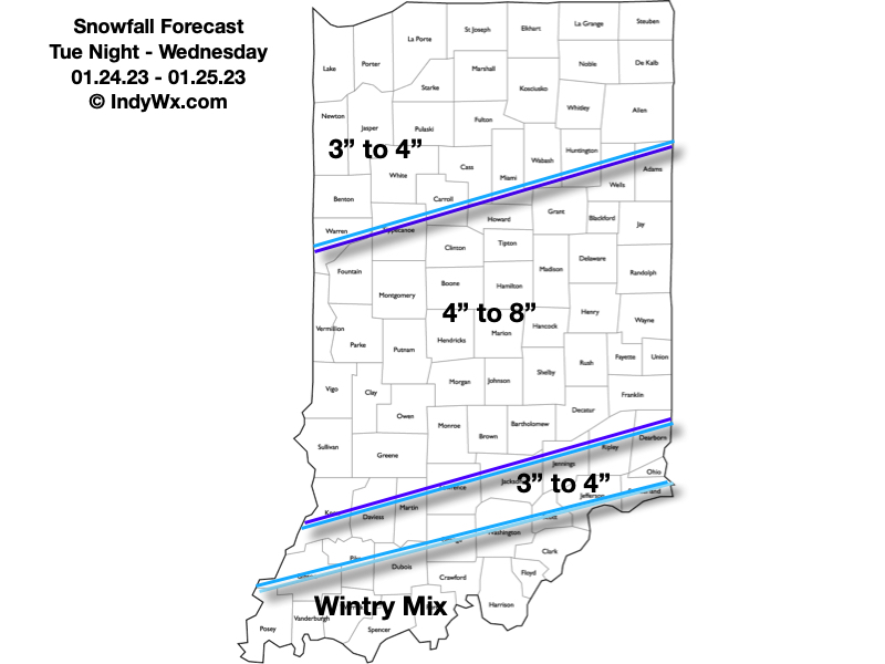
Low pressure will take a “textbook” track from LA Tuesday evening, west TN Wednesday morning, southeast of the OH river Wednesday afternoon and into Ohio by Wednesday evening. Long time Hoosiers know that spells snowy excitement throughout the region and sure enough, we expect an area-wide moderate to heavy snow event.

Now, this won’t be some sort of blockbuster type storm (remember, this kind of pattern doesn’t support such), but the low will be plenty strong enough to tap into the Gulf moisture and throw it north into an airmass that’s just cold enough to support another wet, heavy (paste-like) snow event Tuesday night through Wednesday. As the storm moves off to the northeast, snow will become a bit more powdery Thursday into Friday morning with some additional light accumulation expected in the colder airmass.

Tuesday night – Wednesday snowfall forecast:

Permanent link to this article: https://indywx.com/saturday-early-afternoon-thoughts-and-snowfall-forecast-for-sunday-and-tuesday-night-thursday/

VIDEO: Tracking 3 Accumulating Snow Events Over The Next 5-7 Days…

Updated 01.21.23 @ 8:50a

You must be logged in to view this content. Click Here to become a member of IndyWX.com for full access.  Already a member of IndyWx.com All-Access?  Log-in here.

Permanent link to this article: https://indywx.com/video-tracking-3-accumulating-snow-events-over-the-next-5-7-days/

VIDEO: Long Range Update And Short-Term Look At Our Next Snow Maker…

Updated 12.23.22 @ 7:58a

You must be logged in to view this content. Click Here to become a member of IndyWX.com for full access.  Already a member of IndyWx.com All-Access?  Log-in here.

Permanent link to this article: https://indywx.com/video-long-range-update-and-short-term-look-at-our-next-snow-maker/

VIDEO: Blizzard Conditions Into Friday; Another Snow Maker Arrives Just After Christmas…

Updated 12.22.22 @ 5:54p

You must be logged in to view this content. Click Here to become a member of IndyWX.com for full access.  Already a member of IndyWx.com All-Access?  Log-in here.

Permanent link to this article: https://indywx.com/video-blizzard-conditions-into-friday-another-snow-maker-arrives-just-after-christmas/

Client Brief: Use This Morning To Finalize Prep For Blizzard Conditions And Dangerous Cold Tonight – Christmas Eve…

Updated 12.22.22 @ 7:40a

Type: Severe Winter Weather

What: Heavy snow, blizzard conditions, dangerously cold temperatures

When: Late this afternoon through Christmas Eve

Temperatures: Falling from the upper 30s (Thursday afternoon) to 0° to 10° below zero (Friday morning).

Wind: NW 15-25 MPH, shifting to the WSW and increasing to 25-40 MPH with gusts to 50 MPH

Blowing/ Drifting: Severe

Pavement Impacts: Plowing and salting will be required throughout the region.

Summary: Light rain is overspreading central Indiana this morning as moisture is slowly pulled northward ahead of the approaching arctic cold front. That arctic front is still expected to plow across the state this afternoon (just after lunchtime across western IN, between 3p and 4p for Indianapolis, and by 7p – 8p for our far eastern IN neighbors). Once the front hits, you’ll notice a dramatic wind shift to the northwest and increase to 20-30 MPH with higher gusts, along with a temperature plummet. We’ll likely see temperatures fall more than 20° in less than 90 minutes once the arctic front passes.

As all of this is taking shape, a wave of low pressure will move from southwest IN late afternoon into eastern MI by Friday morning. Long time Hoosiers know that’s a classic track to deposit a nice snowstorm around these parts. Rain will change to snow in the city around, or just after, 4p and we’ll notice the swath of snow growing in overall coverage and intensity as the low pressure system deepens. Periods of heavy snow can be expected at times tonight.

Meanwhile, winds will continue to increase to 25-35 MPH sustained with gusts to 50 MPH tonight, continuing through the day Friday and into the first portion of Christmas Eve morning. These persistent strong winds won’t only potentially lead to power outages, but continuous blowing and drifting issues through the aforementioned period. Blizzard and whiteout conditions will continue at times. Snow removal efforts will likely have to continue into Christmas Eve to account for the severe blowing and drifting on area roadways, especially north-south roadways. While the heavy snow will come to an end early Friday morning, light snow and blowing snow will persist through the day Friday and into early Christmas Eve morning.

Finally, the dangerous cold is going to be a big problem with this multi-faceted winter storm. After we fall to below zero Friday morning, highs on Friday likely won’t make it back much above 0°. Add in the wind and wind chill values of more than 30° below zero can be expected.

Confidence: High

Next Update: This evening (video discussion)


Permanent link to this article: https://indywx.com/client-brief-use-this-morning-to-finalize-prep-for-blizzard-conditions-and-dangerous-cold-tonight-christmas-eve/