Published Friday, 10.04.24 Well, well, well, here we are again. Is this finally the winter where we can shake the snow drought? It’s been since the winter of ’13-’14 that…
You must be logged in to view this content. Click Here to become a member of IndyWX.com for full access. Already a member of IndyWx.com All-Access? Log-in here.
Updated 09.03.24 @ 3:05p The year continues to fly by. Now that we’re officially into meteorological fall, I wanted to take a moment to share a few brief early thoughts…
You must be logged in to view this content. Click Here to become a member of IndyWX.com for full access. Already a member of IndyWx.com All-Access? Log-in here.
Right out of the gate, let’s look at the pattern drivers over the course of the next couple of weeks. By now, you know this starts with the MJO. One has to love the alignment of at least quickly moving out of the current warm phases and into the colder phases. By the 28th, both the GFS and European show us emerging into those colder phases.
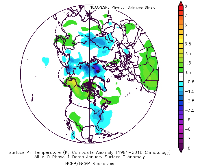
The thought here is that we sneak into Phase 8 prior to month’s end and then roll into Phase 1 as we get into early January. The respective temperature composites are below.
MJO: Phase 8 December
MJO: Phase 1 January
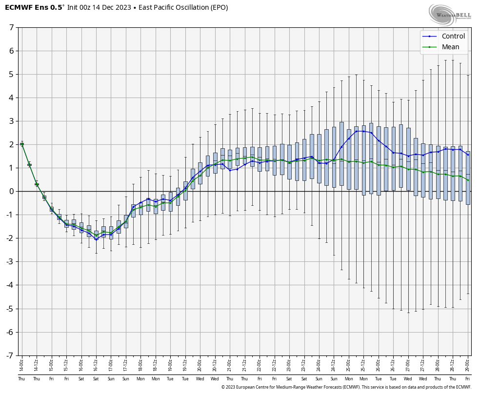
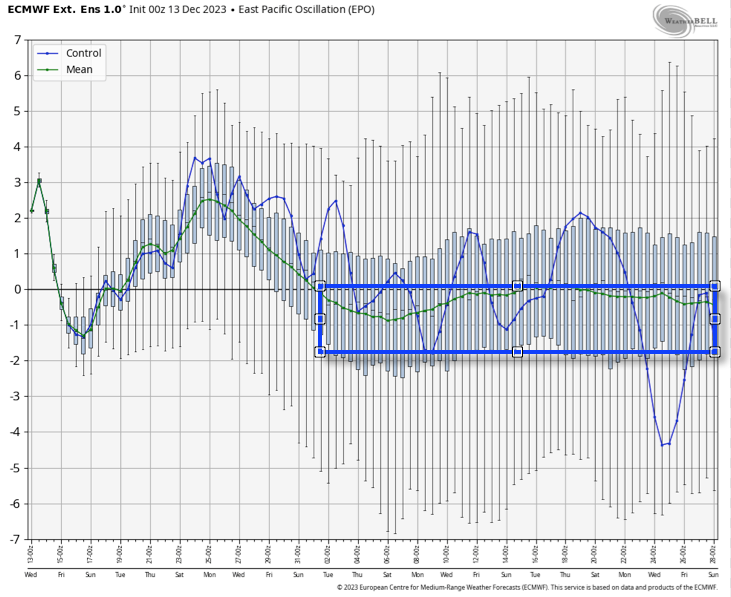
That leads us to the PNA and EPO. (Remember, we’ll put more weight into the influence the NAO and AO can have on the regime after mid-January).
The PNA, or Pacific North American pattern, remains in a favorable state for eastern cold.
“Positive” PNA composite pattern
However, the EPO doesn’t want to play nice and will put pressure on any sort of sustained, meaningful cold getting involved over the next 10 days- that is until the MJO gets into the cold phases.
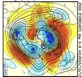
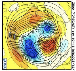
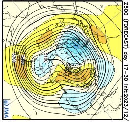
The JMA Weeklies show the progression of the upper pattern best, in my opinion, from any of the long range data that’s currently available for the late December-1st half of January timeframe.
Week 1
Week 2
Weeks 3-4
We’ve had several new subscribers of IndyWx.com All-Access over the past couple of weeks so I wanted to take time to drop a direct link to our annual Winter Outlook. As we get set to put a bow on the first month of meteorological winter, there’s no change to our ongoing idea of the winter as a whole here.
I originally thought the shift to a colder pattern would take shape around 12/20 (give or take a couple of days). While that idea appears to be too aggressive, there’s certainly no backing away from the colder pattern progression as a whole, at least from my perspective. The expectation is that we do, indeed, get into the colder phases of the MJO and that sets off the larger global signal that will likely shift the EPO into a colder phase. It’s interesting that the European Weeklies show this exact thing taking shape down the road (once past 1/1).
While we’re not of the thought this evolves into anything frigid (some sort of overwhelming arctic air mass, for example), we do want to double down on the idea of a slightly colder than normal regime taking hold as we get into the new year. The thought here is that this slightly colder than normal pattern will also have staying power through a good chunk of January, given where I believe the MJO will spend the majority of time. What’s also of interest is the energized southern stream beginning to show itself (going to be one heck of a storm roaring out of the Gulf this weekend). I’d imagine we’re only just beginning to see the active pattern take hold and it won’t take much to get a storm or two to try and phase with northern stream energy if we see the evolution take hold that I envision down the road. At the very least, it’s certainly not a boring pattern.
We’ll have more detailed thoughts on the weekend and next week’s pattern in our updated Client video that will be posted a bit later today!
We do it every year around this time and while some years have certainly been tougher than others, there’s always something special about this time on the calendar. Perhaps it’s the cooler days, the longer nights, the return of football season, or better yet the thoughts (at least to this winter lover) of the first flakes of the season that loom in the not too distant future. However you view this time of year, I hope you can find a way to enjoy the upcoming winter season.
Like most years, there will likely be a little something for everyone, and before diving in too far, we always like to remind folks that long range forecasting is always a challenge, albeit a welcome one at that. While there’s simply no way to be certain about specifics 2-5 months in advance, more times than not, we can at least provide an idea of the overall upper pattern that should generate predominant precipitation and temperature regimes in the colder months ahead.
Without further ado, lets dive in…
We’re in uncharted territory, at least compared to the past (3) years. After a rare triple dip Nina event, a strong El Nino is here and anticipated to stick around, at least in a moderate fashion, through the winter.
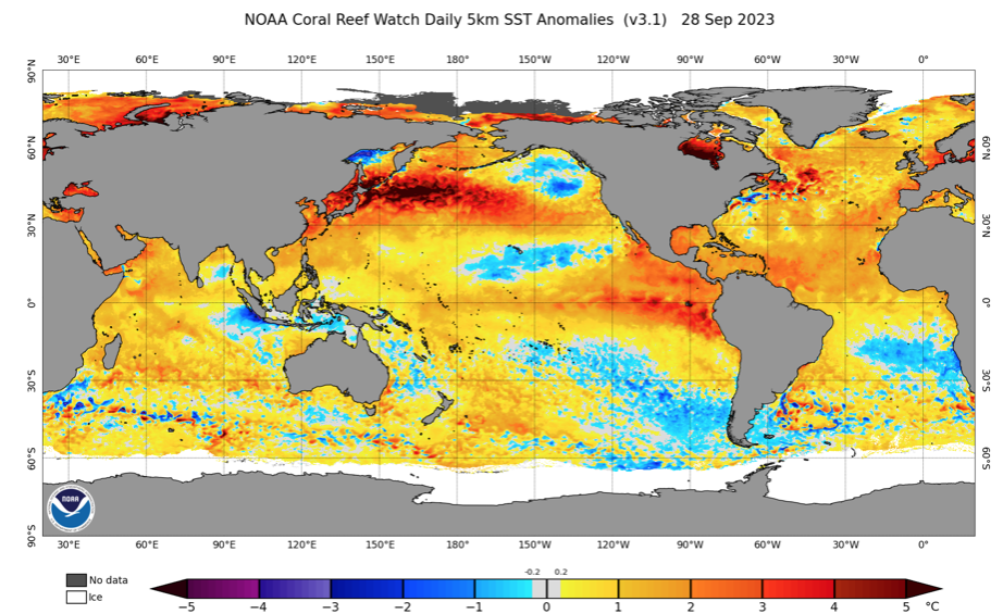
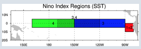
It’s important to note that not one Nino event is identical to another. What’s of particular interest with this year’s event is that a lot of the longer range model guidance begins to weaken the Nino as we get into the middle and latter part of the winter, while migrating the warmest anomalies west (more into the central region: region 3 and region 3.4). By the way, here’s an interesting article that sheds more light on the various regions and indices.
Ultimately, that is the golden ticket to what this winter becomes in my opinion. While far from etched in stone, it’s my belief that when you have a Nino event coming off it’s peak during the winter, there’s a better opportunity to get the warmest anomalies more into the central regions as the weakening takes place. Should this happen then we’re talking about increasing prospects of cold and snow. Meanwhile, if the warmest SST anomalies remain tucked into 1+2, it’ll likely be another ugly winter for snow and cold lovers.
On that note, the past 5 winters have only produced an average 14.1″ of snow in Indianapolis. Only ’20-’21 was close to average at 22.2″. To add salt to the wound, if you take out the record snowiest ’13-’14 (whopping 52.2″), our 10 year snow average is 12.6″.
Lets take a look at some of the various modeling for the upcoming meteorological winter (December through February).
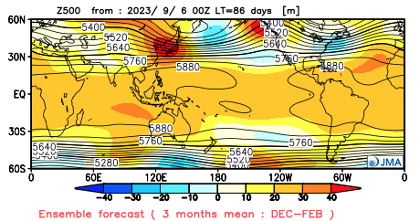
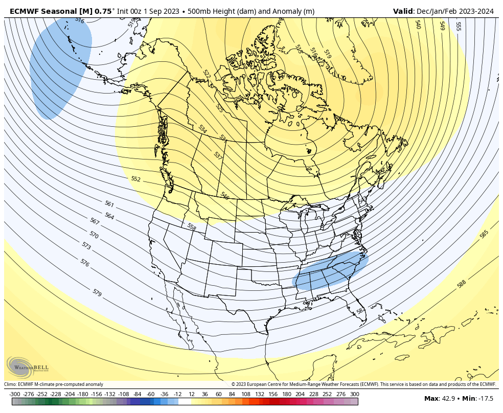
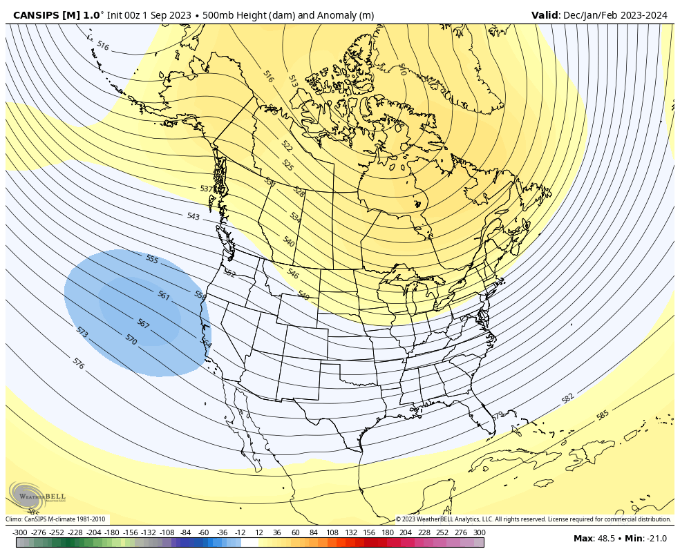
JMA Seasonal
European Seasonal
Canadian Seasonal
The seasonal guidance shown above is the most aggressive, collectively, I can recall for quite some time from this distance. Note each of the models above indicate the opportunity for blocking with the active southern stream underneath that we come to expect in an El Nino.
We built our analog set (first shared with Clients on 9/3) with the baseline including 1st year moderate to strong Ninos.
1957-1958
1972-1973
1991-1992
2002-2003
2009-2010
1982-1983
2015-2016
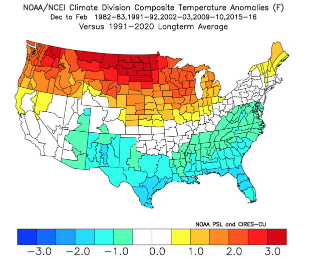
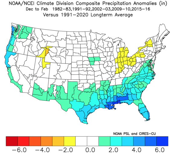
In addition, we’re also looking at critical SST configuration in the NPAC and northwest Atlantic. Out of the list above, heaviest focus centers on ’82-’83, ’91-’92, ’02-’03, ’09-’10, and ’15-’16.
A blend of those years gives us the following temperature and precipitation pattern for meteorological winter:
Temperatures
Precipitation
What does this all mean to me: Central Indiana
Last year we thought the winter would get off to a much quicker, harsher start than years past. While November didn’t disappoint from a snowfall perspective (2.8″ compared to an average of 0.8″), it was still a slightly warmer than normal month. The cold came in December, but it was a “dry” cold with below normal snowfall (1.6″ compared to an average of 6.4″).
The more I look at trends for this winter, the more I like the idea of increased high latitude blocking compared to years past along with the evolving, more central based Nino event. With that said, recent trends have me a bit hesitant to go “all in” on the potential of this winter. We’ll lean slightly warmer than normal with slightly below normal snowfall for the winter as a whole. That said, local perception will be interesting as I envision a snowier winter compared to the past couple years. While the primary storm track should be suppressed this year with below normal precipitation, thanks to the El Nino, that doesn’t necessarily mean we’re in for a snowless winter.
The numbers please…
Temperatures: December through February averaging 0.5° to 1° above normal as a whole
Precipitation: Below normal precipitation is expected through the 3 month winter period (75% of normal is our call) with slightly below normal snowfall. We forecast 20″ of snow (1st flake to last flake).
Whatever the winter provides, I hope you and your family enjoy and stay safe!
The extended stretch of quiet weather has given us time to finalize the initial set of analogs we’ll lean in on for the upcoming winter. Speaking of that, our annual Winter Outlook will be published Friday, October 27th.
While long range seasonal models differ on the placement of warmest sea surface temperature (SST) anomalies, we’re refraining from going “all-in” on a modoki Nino event as of now. This is something that no doubt will have our attention as we go through the course of the next several weeks. It’ll be interesting to watch the trends. The modoki, or central based, warm event would go a long way in upping the ante for a colder, stormier winter, locally. This is something that’s possible but we still have more questions than answers with how this evolves.
SST configuration as of September 1, 2023:
Our initial set of analogs includes the following years:
1957-1958
1972-1973
1991-1992
2002-2003
2009-2010
1982-1983
2015-2016
We’re looking at 1st year Nino events of moderate to strong intensity. (Most modeling peaks this event in the +1.5 to +2 range in Nino region 3.4). In addition, we’re also looking at critical SST configuration in the NPAC and northwest Atlantic. Out of the list above, heaviest focus as of now centers on ’82-’83, ’91-’92, ’02-’03, ’09-’10, and ’15-’16.
A blend of those years gives us the following temperature and precipitation pattern for meteorological winter:
Temperature
Precipitation
There’s a lot more that goes into our seasonal outlooks than simply taking a blend of analogs, but this will serve as a nice starting point from this distance. It’ll be very interesting to watch the migration (or lack thereof) of warmest SSTs currently “tucked in” to Nino regions 1+2 and 3 into potentially a more central, or region 3.4 event.
Make it a great Labor Day weekend and know we’ll have much more to come in the weeks ahead on our winter ’23 – ’24 thoughts…