Category: Windy

Tuesday Morning Rambles: Shower Chances Return Today…

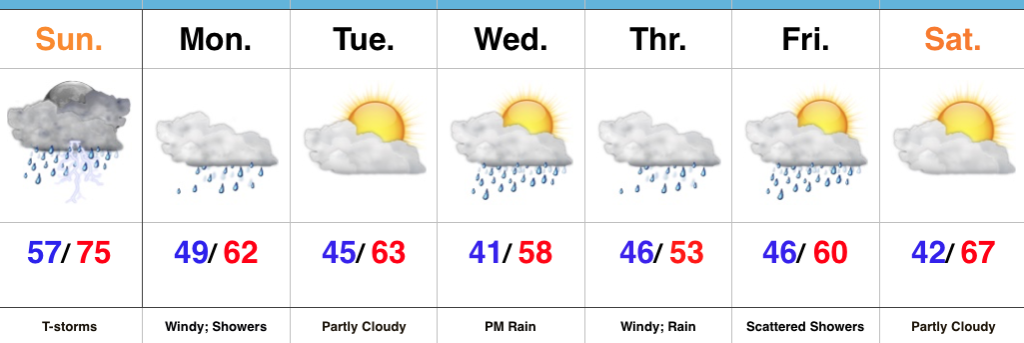
1.)  2017 continues to fly along.  August features 3.13″ of rain during the month and temperatures that start out with an average high and low of 84°/ 65° and 83°/ 62° to end the month.  Needless to say, temperatures this weekend will feature well below normal conditions that will feel more like it should jumping forward 6 weeks, or so.

2.)  Moisture returns today and results in scattered shower coverage this afternoon and Wednesday.  Most of both days will remain rain-free, but don’t be surprised by a passing shower at times.

Scattered showers return this evening across central Indiana.

3.)  More widespread coverage of showers and thunderstorms arrive Thursday afternoon into Friday morning as a strong cold front presses into the state.  Localized heavy rain is possible and rainfall totals of 0.50″-1.00″ can be expected (with locally heavier amounts under stronger storms) between now and Friday.

4.)  As surface low pressure wraps up over the Great Lakes Friday, it’ll help pull unseasonably cool air south into the state, along with gusty northwest winds.  In fact, temperatures will remain steady or slowly fall as we move through the day Friday.  It sure won’t feel like the first weekend of August as temperatures tumble into the 50s area-wide Saturday morning.
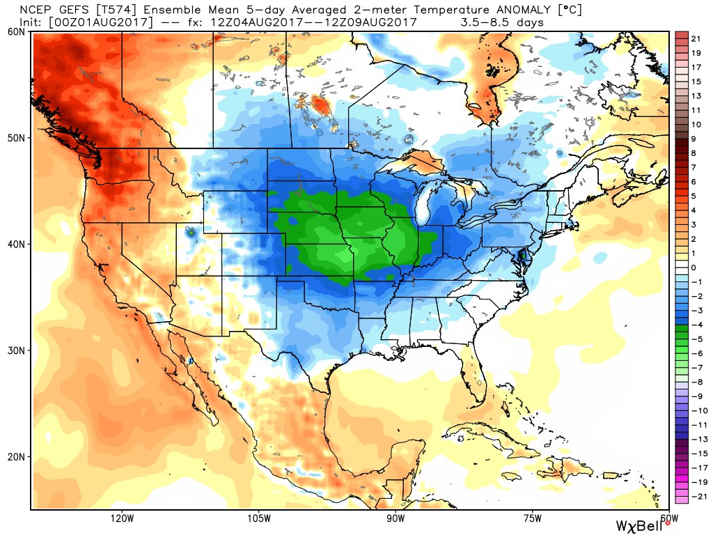
Temperatures will feel more like late-September this weekend.

Permanent link to this article: https://indywx.com/2017/08/01/tuesday-morning-rambles-shower-chances-return-today/

VIDEO: Late Week Storms And Much Cooler Next Week…

You must be logged in to view this content. Click Here to become a member of IndyWX.com for full access.  Already a member of IndyWx.com All-Access?  Log-in here.

Permanent link to this article: https://indywx.com/2017/05/16/video-late-week-storms-and-much-cooler-next-week/

More Heavy Rain Today, But Improving Conditions As We Move Into The Weekend…

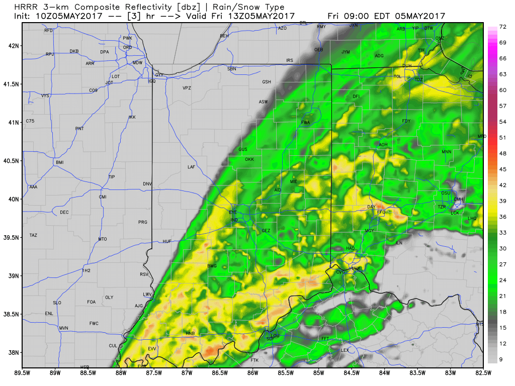
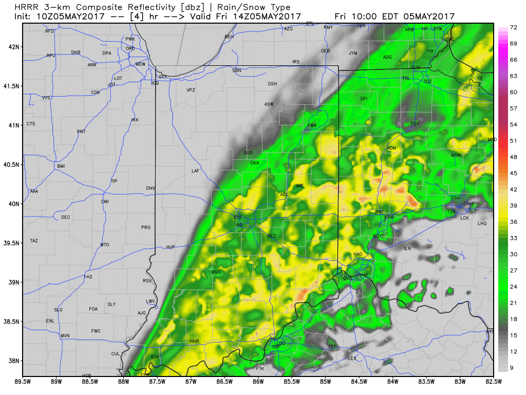
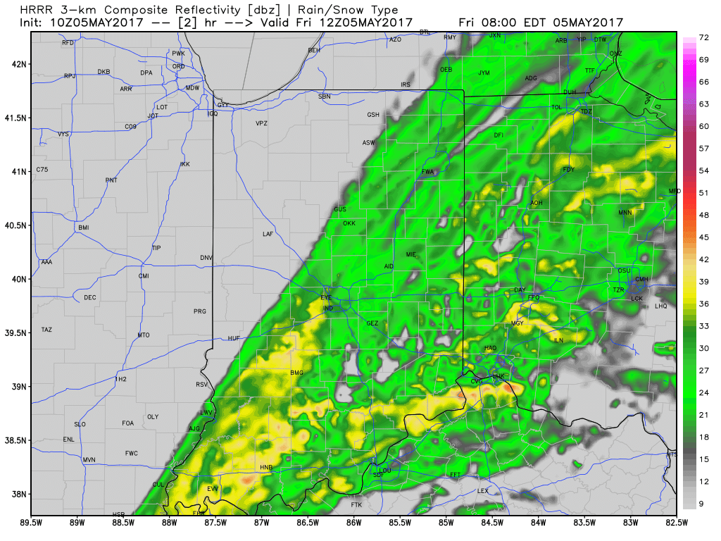
After a relative “lull” in the rainfall coverage and intensity overnight, rain is expanding in coverage and intensity yet again this morning.  While there will be a rather sharp cut-off to the west, additional heavy rains are ahead from northwestern Indianapolis ‘burbs (including places such as Brownsburg, Whitestown, and Sheridan), Indianapolis, and points south and east.

HRRR simulated radar shows this rain shield nicely as we progress through mid and late morning.

Additional rainfall of 1″-1.5″ is likely from Indianapolis and points south and east with this band of rain before drier weather finally works in here this afternoon and evening.  Otherwise, expect continued windy, cold, and raw conditions today as temperatures remain in the 40s this afternoon, including wind chills in the 30s.
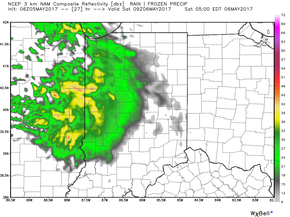
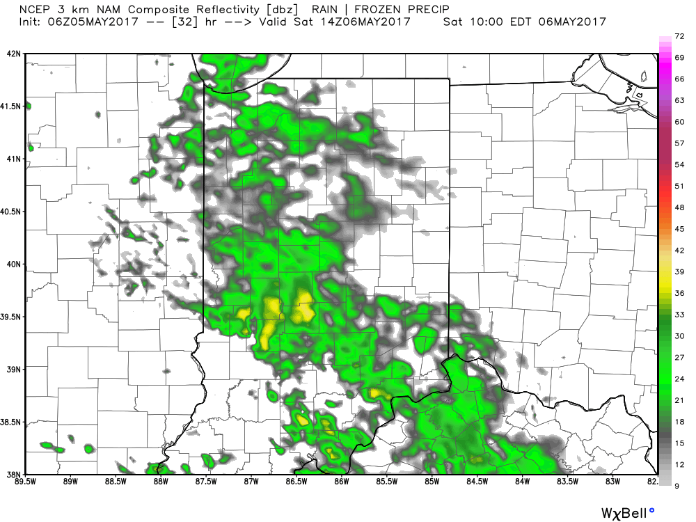
Looking ahead, one last batch of rain will arrive on the scene Saturday morning.

We’ll finally get rid of the rain and introduce a drier regime Saturday afternoon into Sunday, including a sunny close to the weekend.  With the drier air, overnight lows will fall to frosty levels Sunday and Monday mornings (lower to middle 30s).

More on the longer range this weekend!

Permanent link to this article: https://indywx.com/2017/05/05/more-heavy-rain-today-but-improving-conditions-as-we-move-into-the-weekend/

 VIDEO: Heavy Rain & Flooding Update…

You must be logged in to view this content. Click Here to become a member of IndyWX.com for full access.  Already a member of IndyWx.com All-Access?  Log-in here.

Permanent link to this article: https://indywx.com/2017/05/04/video-heavy-rain-flooding-update/

Flooding Concerns Return…

Highlights:

  • Heavy rain returns
  • Unseasonably cool
  • Drier weather returns late in the weekend

Live Near A Body Of Water? Keep An Eye On The Level…Central Indiana will deal with an extended period of rain, occasionally heavy, tonight through Friday afternoon.  With saturated soils in place, an additional widespread 2.5″-3.5″ (with locally heavier amounts) between now and Saturday morning, flooding concerns are very high.  As the lead off states, please remain aware of water levels if you live near a creek, stream, or river.  The other aspect of this storm will be unseasonably chilly air and gusty easterly winds that will shift to the north Friday night into Saturday.

The weekend will provide a drier trend, but the improvements will be slow to occur.  Showers remain in our Saturday forecast before drier air finally wins out Sunday with sunshine.  The worry once to Sunday and Monday mornings will be the potential of frost and freeze conditions- especially in communities away from downtown.  Remember, no planting around these parts until after Mother’s Day!  😉

Shower chances return by the middle of next week!

Upcoming 7-Day Precipitation Forecast:

  • Snowfall: 0.00″
  • Rainfall:  3″ – 4″

Permanent link to this article: https://indywx.com/2017/05/03/flooding-concerns-return/

Unseasonably Chilly; Another Heavy Rain Maker Blows Into Town…

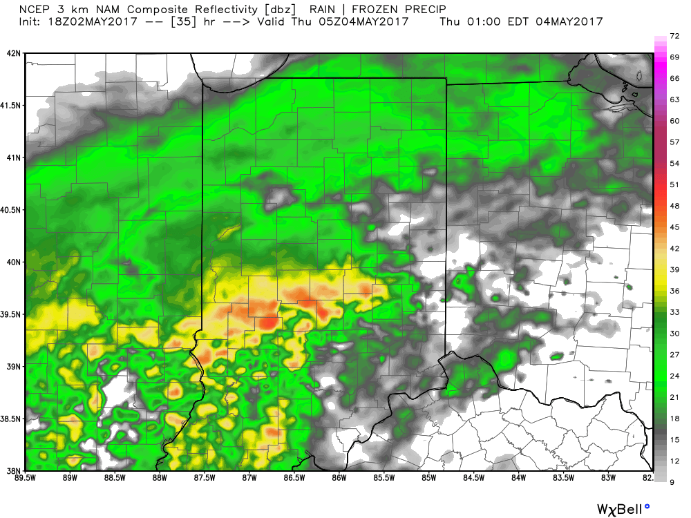
Clouds will lower and thicken Wednesday morning and give way to an expanding rain shield late morning into the early afternoon hours.  Initially this rain won’t be heavy, but will begin to increase in overall coverage and intensity as we progress into the nighttime hours.

Forecast radar around lunchtime shows rain increasing across central IN.

Rain becomes heavy Wednesday night.

The culprit behind this new heavy rain maker is a deepening surface low pressure system that will slowly track from Arkansas (Wednesday night) northeast along the Ohio River (Thursday) and into Ohio (Friday).  Not only will this spread heavy rain across central Indiana, but will also result in strong and gusty easterly winds Thursday into Friday, and unseasonably cold air.  In fact, temperatures Friday will likely remain in the 40s across central IN with wind chills in the 30s.  Add in that wind-driven rain and we have the makings for an UGLY day.

Periods of heavy rain will fall on the region Wednesday night into Friday and by the time all is said and done (Saturday night) widespread rainfall of 3″ is likely across most of central Indiana.  Locally heavier totals will be possible where the most persistent heavy rain bands set-up shop.

We’ll begin to dry things out Saturday night into Sunday, but unseasonably chilly air will remain.  Lows over the weekend into early next week will grow cold enough to allow patchy frost to develop in outlying communities.  We think low to mid 30s will be common across the region Sunday and Monday mornings.

Permanent link to this article: https://indywx.com/2017/05/02/unseasonably-chilly-another-heavy-rain-maker-blows-into-town/

Another Big Rain Maker; Unseasonably Chilly…

Highlights:

  • Limited sunshine
  • Another big rain event awaits
  • Prolonged period of chilly weather

Jackets And Rain Gear Needed…Without question, Tuesday appears to be the “pick of the week” across central Indiana as we get into some briefly drier air.  Enjoy it, as a new storm system will deliver heavy, wind-driven rain and unseasonably chilly air as we progress through mid and late week.

Clouds will lower and thicken Wednesday morning and give way to an expanding shield of rain as morning wears into afternoon and evening.  As the surface low tracks closer to the region, an increasingly strong and gusty easterly wind will develop and combine with the chilly rain to lead to a truly “raw” period of weather to close the work week.  It’ll feel more like early-March than early-May around these parts.  Unfortunately, it still appears as if this next storm will deliver hefty rainfall totals on our already water-logged landscape.  Data paints a widespread swath of 2″-3″ totals with locally heavier amounts.  Flooding, once again, appears likely and if you live near a body of water, it’ll be important to keep a close eye on water levels Thursday into the weekend.

Widespread rain Friday should slowly give way to improving weather conditions over the weekend: scattered showers Saturday and dry, cool weather Sunday.  Speaking of cool, temperatures will continue to run well below average, and lows Saturday through Monday mornings’ may result in patchy frost in outlying areas…

Upcoming 7-Day Precipitation Forecast:

  • Snowfall: 0.00″
  • Rainfall: 2.50″ – 3.50″

Permanent link to this article: https://indywx.com/2017/05/01/another-big-rain-maker-unseasonably-chilly/

Keeping A Close Eye On Midweek…

For the purpose of this post, we’ll focus on our next storm system that, at the very least, promises to deal more wet weather to central Indiana come Wednesday night into Friday.  Additionally, this will be a much cooler storm with temperatures struggling to get out of the 40s during the day Thursday, as gusty easterly winds reach 30+ MPH.  At the extreme, this could be another event that deposits widespread 2″+ rainfall totals across central Indiana…

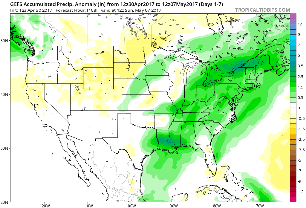
The latest 7-day precipitation anomaly off this afternoon’s GEFS shows the wet pattern that will remain intact over the upcoming (7) day period.

The individual GFS ensemble members are truly concerning, especially given just how wet we currently are.  We note some members suggest additional 3″-4″ totals- with over 50% of that coming from our midweek storm.
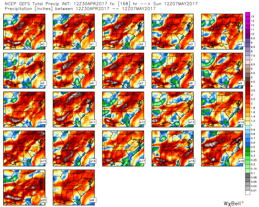
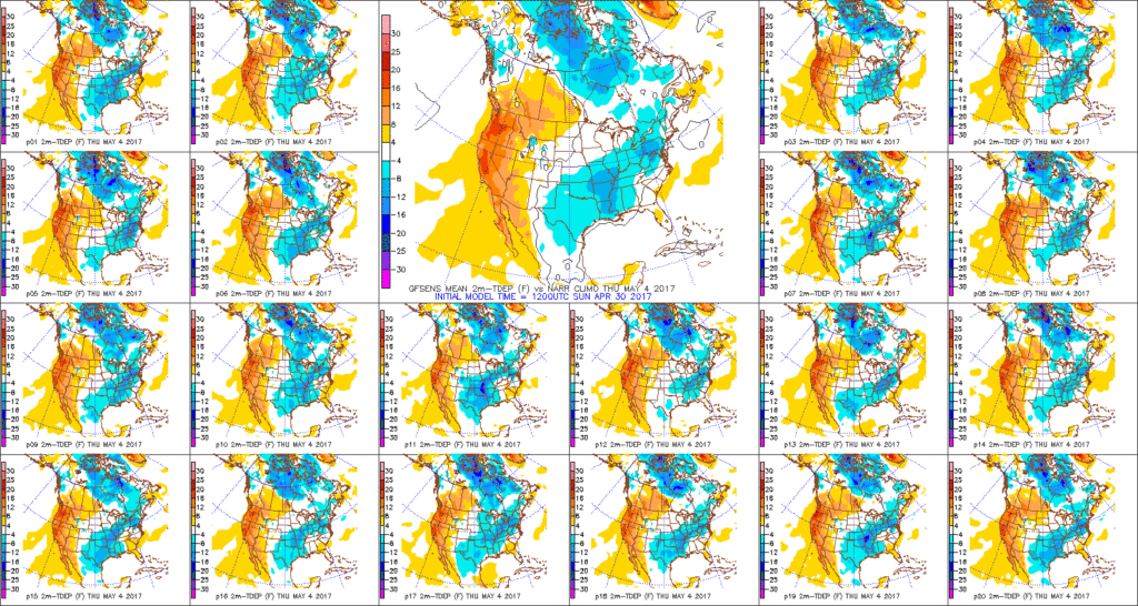
We’ll keep a close eye on model data over the next couple of days, but as of now, we suggest planning for additional hefty rain totals in the Wednesday night through Friday time frame.  Also of interest will be the extreme cool associated with this storm.  As previously mentioned, the majority of the day Thursday will be spent in the 40s (more like early-March than early-May).  Factor in a gusty easterly breeze and we’ll have the makings for a truly “raw” weather day across the region.
Permanent link to this article: https://indywx.com/2017/04/30/keeping-a-close-eye-on-midweek/

More Heavy Rain And Storms Ahead; Cooler Week On Deck…

Highlights:

  • Widespread rain and strong storms today
  • Falling temperatures, windy, and wet Monday
  • Midweek storm brewing

Flooding Concerns Remain High…Another slug of moisture will lift north through central Indiana this afternoon into the nighttime hours.  Locally heavy rain will result in big flooding concerns as saturated soils are in place and many creeks and streams are already out of their banks.  Throw in an additional 1″-2″ with locally heavier totals and you have the makings of a dangerous flood situation into early week.  If that wasn’t enough to be concerned about, we’ll also have to watch how things evolve closely this afternoon for the potential of severe thunderstorms.  Damaging straight line winds are of greatest concern.

We’ll transition to a much cooler regime to open the new work week with gusty winds and showers continuing.  Temperatures will fall through the 50s during the day.  Jackets will be required!

Tuesday will provide a brief break from the wet weather and we should also introduce some sunshine for a while.  Unfortunately, we won’t have much time to dry out as a wet, windy, and chilly storm is brewing Wednesday evening into Thursday.  Widespread rain (some heavy) will combine with a raw easterly wind and temperatures in the 50s to lead to a rather miserable Thursday.

While shower chances remain early Friday, the theme heading into next weekend is a drier one and we should finally enjoy very pleasant weather by Saturday.

Upcoming 7-Day Precipitation Forecast:

  • Snowfall: 0.00″
  • Rainfall: 1.50″ – 3.00″

Permanent link to this article: https://indywx.com/2017/04/30/more-heavy-rain-and-storms-ahead-cooler-week-on-deck/

Gearing Up For The “2nd Half…”

Central Indiana has enjoyed a well deserved break in the rain and thunderstorms this afternoon, but, unfortunately, stormy times will return tonight.  With an increasingly moist air mass in place (warm front is currently draped across central IN and slowly lifting north), renewed heavy rain is expected tonight into Sunday.  Dew points will approach 70° and precipitable water values (PWATs) will periodically reach 2″ between this evening and Sunday night.  With that kind of moisture content in the atmosphere, locally heavy, flash flood-producing, rains are a “lock.”  Should you live near a creek, stream, or river, please keep abreast of water levels into early next week and have a plan in place to move to higher ground.

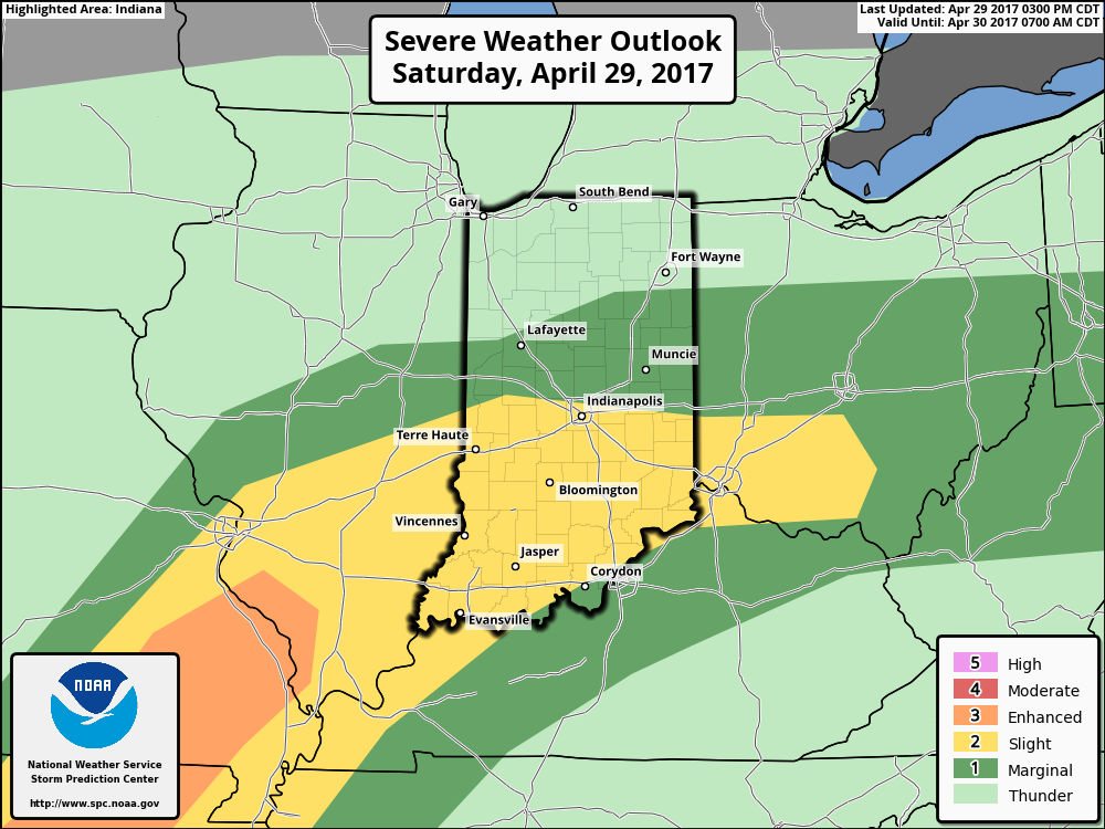
The Storm Prediction Center paints a “Slight Risk” of severe weather across central and southern Indiana tonight.

We think an eastward-advancing line of thunderstorms will blow into central Indiana later this evening (between 9p and midnight).  Some of these may reach strong to severe levels with damaging straight line winds of greatest concern.  Additionally, torrential downpours will occur within this line of storms.

Overall coverage of rain and thunderstorms should diminish Sunday morning before ramping up and increasing in overall coverage and intensity (yet again) Sunday evening and night.  In fact, we may be looking at another severe weather episode Sunday night- again with straight line damaging winds of greatest concern.  By the time all is said and done we expect an additional 1″-2″ of rain across central Indiana with locally heavier 3″+ amounts where storms train over the same area.  Obviously, with saturated soils in place across central Indiana, this amount of rain will create flood concerns into Monday morning.  By the time we get to Monday, the big weather story will be strong and gusty NW winds, much cooler air (falling temperatures through the 50s) and nuisance-level showers.

Another heavy rain maker looms Thursday and we’ll cover that in our updated 7-day later tonight or Sunday.

Permanent link to this article: https://indywx.com/2017/04/29/gearing-up-for-the-2nd-half/

IndyWx.com