Category: Windy
 Highlights:
- Big changes this weekend
- Relatively calm Thanksgiving week
- Chilly Thanksgiving
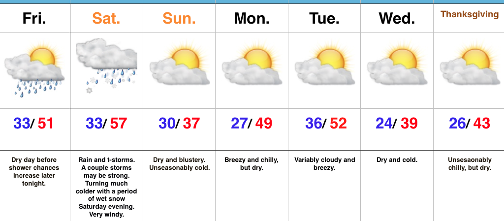
Storms To Snow This Weekend…An approaching storm system will lead to an active open to the weekend. Beforehand, thankfully, we’ll close the work week out on a rather quiet note. The daytime hours will remain dry before moisture begins to return this evening. An initial round of showers will move across central Indiana (thinking between 8p-9p) before steadier and heavier rain and embedded thunderstorms blow into town Saturday. A strengthening surface low will move from the central Plains tonight and into the southern Great Lakes Saturday. This will lead to a briefly milder surge of air Saturday morning into the early afternoon before a cold front sweeps through the state and leads to a sharply colder close to the day. Right ahead of the cold front, a skinny, but potentially intense, line of thunderstorms will track across central Indiana late Saturday morning into early Saturday afternoon. Damaging wind gusts are possible as this thin line of storms advances across central and southern Indiana. Winds will then shift around to the northwest and help drive much colder air into the region through the afternoon and evening. In fact, we’ll turn cold enough to allow precipitation to end as a touch of wet snow Saturday evening.
We’ll wrap up the weekend and kick off Thanksgiving week on a much calmer note. Chilly high pressure will build in Sunday, allowing sunshine to return, but temperatures will run around 15° below normal. A dry cold front will pass through the state Tuesday. With the exception of a wind shift and a few more clouds we really shouldn’t expect much more in the way of “excitement.” This will allow unseasonably cool air to return for Thanksgiving, itself.
Upcoming 7-Day Precipitation Forecast:
- Snowfall: Trace – Dusting
- Rainfall: 1.00″ – 1.50″
Permanent link to this article: https://indywx.com/2017/11/17/weekend-of-changes-storms-to-snow/
 Highlights:
- Wet Wednesday
- 2nd cold front Friday night
- 3rd cold front arrives Tuesday night
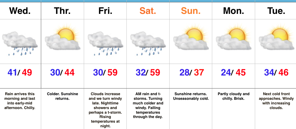
Busy Weather Pattern…Rain is pressing into central Indiana this morning ahead of the first of three cold fronts we’re tracking between now and early Thanksgiving week. Rain will be most widespread this morning into the early afternoon hours before diminishing mid to late afternoon. Reinforcing chilly air will blow into town tonight and we’ll be in between storm systems Thursday.
Our second storm system will lead to increasing clouds Friday afternoon with showers and thunderstorms arriving overnight into Saturday morning. Due to the slower timing of this storm, the late week severe threat has diminished significantly. Nonetheless, it’ll be a windy afternoon and we’ll notice rising nighttime temperatures Friday as the cold front approaches. Morning rain will continue Saturday before a sharp transition to much colder conditions with falling daytime temperatures. We’ll kick off Thanksgiving week on a dry and cold note.
Finally, yet another cold front will approach Tuesday night. Once this front sweeps through the state, the coldest air of the season will settle into the area just in time for Thanksgiving.
Upcoming 7-Day Precipitation Forecast:
- Snowfall: 0.00″
- Rainfall: 1.50″ – 1.75″
Permanent link to this article: https://indywx.com/2017/11/15/multiple-cold-fronts-keep-us-busy/
-
Filed under Autumn, Christmas/ Thanksgiving, Forecast Discussion, Forecast Models, High-latitude Blocking, Rain, T-storms, Thanksgiving, Unseasonably Cool Weather, Weather Videos, Windy
-
November 14, 2017
You must be logged in to view this content. Click Here to become a member of IndyWX.com for full access. Already a member of IndyWx.com All-Access? Log-in here.
Permanent link to this article: https://indywx.com/2017/11/14/video-unseasonably-cold-and-active-pattern-continues/
-
Filed under Autumn, Forecast Discussion, Forecast Models, Rain, Severe Weather, snow, T-storms, Thanksgiving, Unseasonably Cool Weather, Windy
-
November 13, 2017
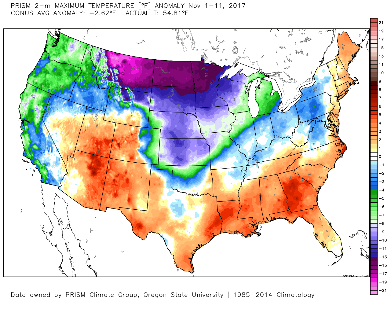
November is off to a chilly start and longer range data suggests the chill grows more significant as we venture through the second half of the month. Officially, IND is running more than 1° below normal through the 12th.
 Despite an active weather week ahead, the open to the new work week will be rather uneventful. Weak high pressure will keep us dry today and Tuesday. Fog and low clouds should give way to an increasingly bright sky by this afternoon (still more clouds than sun today) and partly cloudy skies Tuesday.
Our next weather feature approaches Wednesday in the form of a cold front. This will return showers to the area midweek. Rainfall amounts Wednesday should generally fall in the 0.25″ to 0.50″ range.
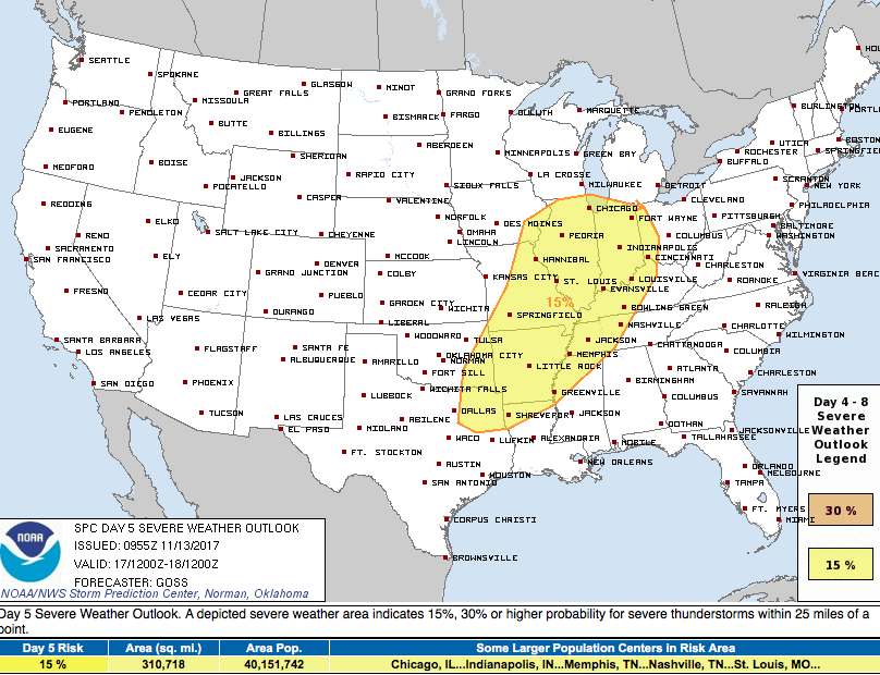
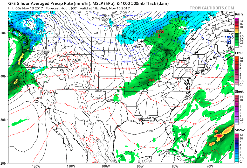 A stronger storm will impact the region as we close out the work week. Strengthening low pressure will track into the Great Lakes and drag a trailing cold front through our region Friday evening. A briefly milder southwesterly air flow will push temperatures close to 60° Friday afternoon/ evening before the sharply colder push of air blows into town for the weekend. The transition may include strong to severe thunderstorms Friday PM, and the Storm Prediction Center (SPC) has outlined a large portion of the region under a severe risk Friday. It’ll be important to stay tuned to future updates. Even outside of potentially damaging thunderstorm gusts, non-t-storm winds will gust over 40 MPH Friday.
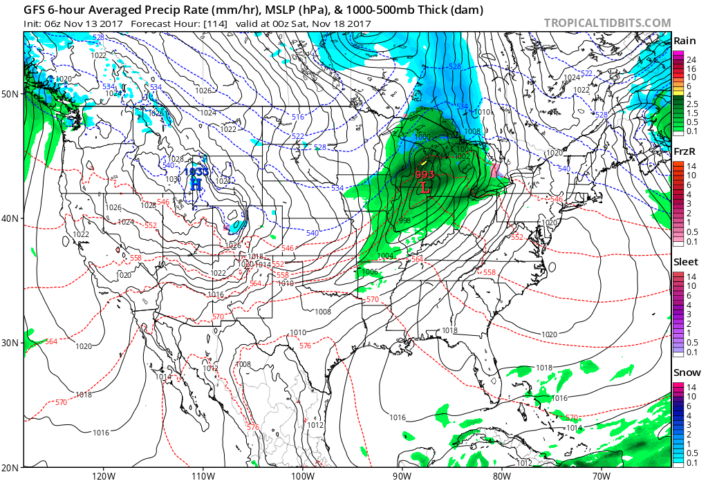
 Once the cold front sweeps through the region, a sharply colder air mass will plunge into the Ohio Valley for the weekend. Overnight data has trended even colder and would suggest falling Saturday temperatures (most of the day will be spent in the 30s) and highs only in the lower to middle 30s Sunday.
 Speaking of cold, Thanksgiving week is looking unseasonably cold, and there’s also the potential of early-season snow (far too early for specifics).
Permanent link to this article: https://indywx.com/2017/11/13/busy-week-of-weather-2/
 Highlights:
- Calm open to the work week
- Two cold fronts impact the region
- Much colder air blows in this weekend
Calm Open; Busy Close…The work week will open with weak high pressure in control of our weather. This will result in sunshine returning along with unseasonably chilly conditions (average highs are in the mid 50s this time of year).
The first of two cold fronts will push through the state Wednesday. Clouds will increase Tuesday evening and showers will blow into town Wednesday morning. Breezy and chilly conditions will go along with the damp weather.
A second (stronger) cold front will impact the area to close the work week. Strengthening low pressure will move through the Great Lakes Friday evening and help pull a briefly warmer air mass into the state. Showers and thunderstorms will be widespread ahead of the approaching cold front and a few of these could be strong to severe. We’ll keep a close eye on things over the next couple of days and update accordingly. Strong and gusty southwesterly winds will reach 40 MPH+ before shifting around to the northwest once the trailing cold front sweeps through the region. This will drive a sharply colder air mass southeast and the potential is there for lingering moisture to end as a touch of wet snow late Friday night. The weekend will feature dry, windy, and unseasonably cold conditions.
Upcoming 7-Day Precipitation Forecast:
- Snowfall: Trace
- Rainfall: 1.00″ – 1.50″
Permanent link to this article: https://indywx.com/2017/11/12/tracking-a-couple-of-cold-fronts-this-week/
 Highlights:
- Sunshine works in today
- Weak weather maker Tuesday
- Chilly pattern turns downright cold to close the week
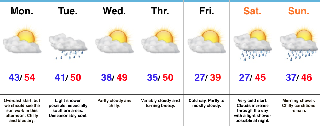
Have The Jackets And Coats Handy…After a rough Sunday filled with flooding and severe weather, we’re opening the work week on a much quieter, albeit much colder, note! An overcast start to the day should gradually give way to increasing afternoon sunshine. We’ve already experienced our high for the day (at midnight) and temperatures for most will remain in the 40s today, coupled with a brisk north breeze.
Our next weather maker will pass to our south Tuesday and this could spread a light shower as far north as central Indiana early Tuesday morning. Better rain chances will remain across southern portions of the state, but even here rainfall amounts will remain light.
Dry, unseasonably chilly conditions will prevail for midweek before a stronger blast of chill pushes in to close the week. This air mass will be of arctic origin and deliver the coldest temperatures so far this autumn. A hard freeze is expected Friday and Saturday mornings. Moisture will return over the weekend with light rain possible Saturday night into Sunday.
Upcoming 7-Day Precipitation Forecast:
- Snowfall: 0.00″
- Rainfall: 0.10″ – 0.30″
Permanent link to this article: https://indywx.com/2017/11/06/unseasonably-chilly-pattern/
-
Filed under 7-Day Outlook, Autumn, Forecast, Halloween, Rain, Sleet, snow, T-storms, Unseasonably Cool Weather, Unseasonably Warm, Windy
-
October 31, 2017
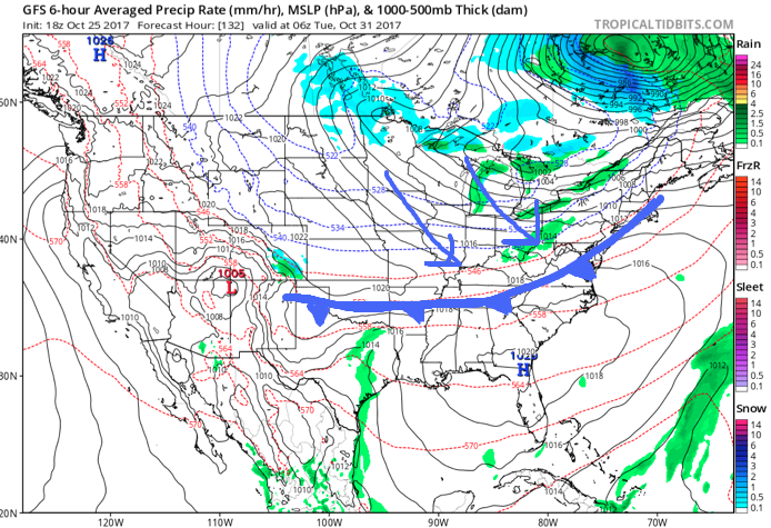
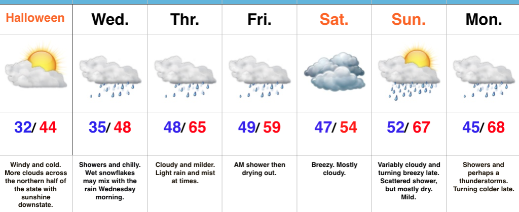 Highlights:
- Cold and blustery Halloween
- Unsettled, milder weather builds in
- Stronger cold front arrives early next week
Spooky Winds…Northerly breezes are strong and gusty and leading to wind chills in the lower-middle 20s across central Indiana this morning. Heavier winter coats will be a smart choice out the door! Otherwise, we’re a state divided from a cloud perspective: the southern half of Indiana will get in on the sunny act much sooner than the northern half of the state. As we look towards the all-important trick-or-treat weather tonight, anticipate dry conditions, lighter winds, and unseasonably chilly conditions continuing.
Our next storm system will approach Wednesday with showers. Rain may be mixed with wet snow or sleet Wednesday morning, but with temperatures above freezing, don’t look for any accumulation. Periods of showers and light rain will continue Thursday into Friday morning. Heavy rain won’t occur, but it’ll be damp at times. Saturday is a bit tricky- some solutions keep rain around, but we’re choosing the more “optimistic” approach for the purpose of this forecast update. Stay tuned.
Saturday will feature considerable cloudiness, slightly cooler air, and breezy conditions before a warmer close to the weekend. A southwesterly flow will help boost highs into the upper 60s Sunday afternoon ahead of an approaching cold front. That cold front will slide through here with showers and a couple claps of thunder Monday. Much colder air returns Monday night into Tuesday.
Upcoming 7-Day Precipitation Forecast:
- Snowfall: Trace
- Rainfall: 0.50″ – 1.00″
Permanent link to this article: https://indywx.com/2017/10/31/a-cold-halloween-on-tap/
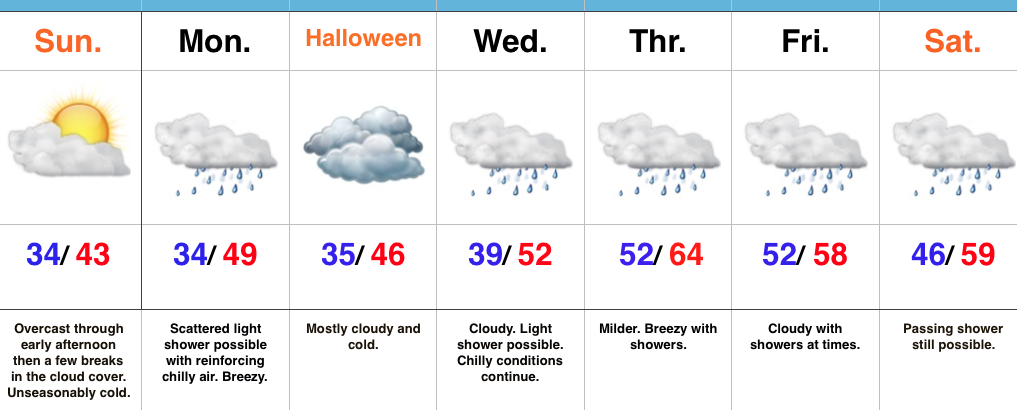 Highlights:
- Late day sunshine
- Reinforcing chill blows in for Halloween
- Temperatures moderate, but rain returns
Warm Costumes Needed This Year…Low level cloudiness blankets the state this morning, but we should see them scour out enough to let sunshine into the picture before we wrap up the weekend. That sunshine won’t stick around long as reinforcing chilly air blows into town to open the new work week. While a shower could accompany the new blast of chill, most of Monday will be rain-free. We’ll notice an increasingly gusty breeze through the day.
Halloween will be dominated by clouds, but the day should be dry, including the all-important stretch Tuesday evening for that trick-or-treating. Bundle up as temperatures will continue to run much colder than average.
A milder southwesterly air flow will dominate our mid and late week weather and while this will result in moderating temperatures, it’ll also help increase rain chances during the period. While it won’t rain the entire time, individual disturbances will result in periods of showers Wednesday through Saturday.
Upcoming 7-Day Precipitation Forecast:
- Snowfall: 0.00″
- Rainfall: 0.50″ – 0.75″
Permanent link to this article: https://indywx.com/2017/10/29/late-day-sunshine-cold-conditions-continue-for-halloween/
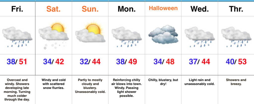 Highlights:
- Cold pattern
- Showers give way to scattered snow flurries Saturday
- Chilly Halloween ahead
Into The Tank…Thursday was a delightful weather day across the region, including sunshine and seasonable temperatures after the cold and frosty start. Unfortunately, weather won’t be nearly that nice through the duration of our current 7-day forecast period.
A cold front is marching east and will pass through the state from this morning to early afternoon (west to east). A band of showers will accompany the frontal passage along with strong and gusty winds shifting to the north, and falling temperatures through the day. Heavier coats will be required by this afternoon.
The air will grow cold enough for lingering moisture to fall as scattered snow flurries Saturday into early Sunday. – Novelty event only, but the first flakes of the season are always fun to see. Otherwise, look for a cold and blustery weekend. Wind chills will fall into the 20s this weekend.
Flipping the page to next week, a reinforcing chilly air mass will settle into the region in time for Halloween. While considerable cloudiness will be with us, trick-or-treat hours should be cold and dry.
Our next storm system builds in the middle of next week with a chilly light rain overspreading the region by Wednesday.
The 2017-2018 IndyWx.com Winter Outlook is now available!
Upcoming 7-Day Precipitation Forecast:
- Snowfall: Trace
- Rainfall: 0.50″ – 0.75″
Permanent link to this article: https://indywx.com/2017/10/27/feeling-more-like-winter-than-autumn/
-
Filed under Autumn, First Freeze, First frost, Forecast Discussion, Forecast Models, Halloween, Harvest'17, Rain, snow, Unseasonably Cool Weather, Windy
-
October 25, 2017
I.) Frost On The Pumpkin: Skies will clear tonight and winds will go calm. Chilly high pressure will briefly build over the eastern Ohio Valley and lead to a calmer period of weather overnight into early Thursday morning. The end result will be the first widespread frost of the season across central Indiana, including many dipping into the lower-to-middle 30s.
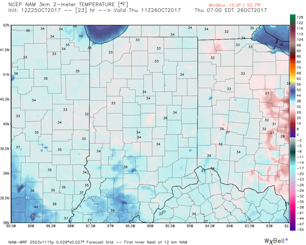 II. Gusty Thursday: After a cold, calm start to our Thursday, southerly winds will become gusty late in the afternoon. This is a result of an approaching cold front that will impact the region Friday.
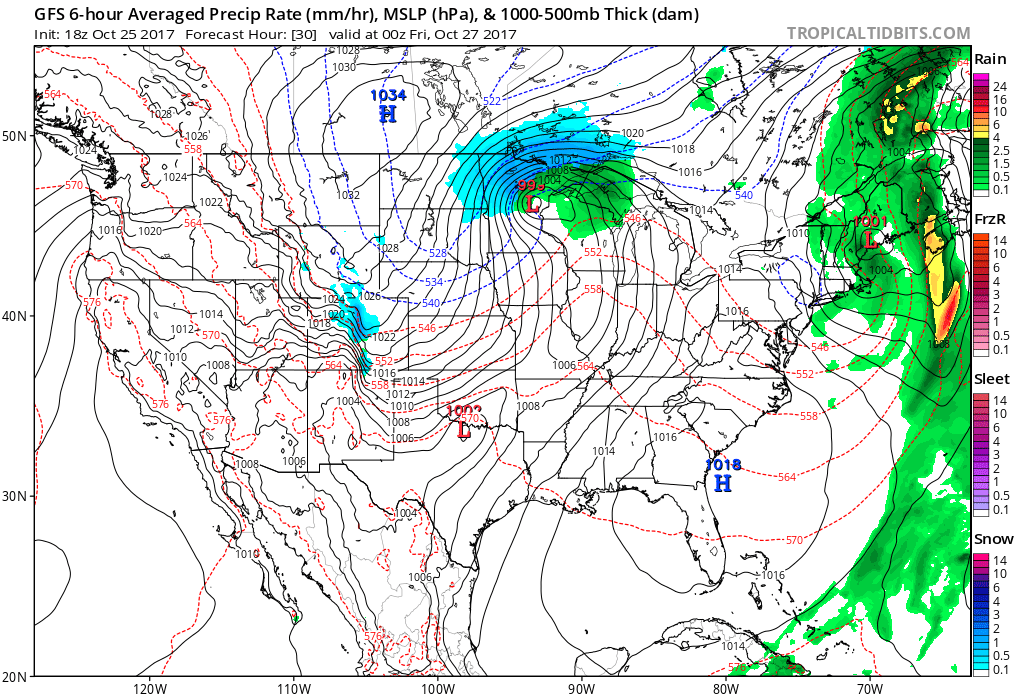 III. Unseasonably Cold Weekend: A cold front will pass Friday afternoon and a band of showers will accompany the frontal passage. Winds will shift to the northwest late in the day and drive in a sharply colder close to the work week. Air will grow cold enough to potentially support snow to mix in with the rain as precipitation comes to an end. Additionally, upper level energy and the colder air mass this weekend (the air will have a bite to it) could support mixed rain and snow showers Sunday. – Novelty stuff only, but those first flakes are always special to see. Nonetheless, temperatures will run well below normal. In fact, highs will be closer to our average low temperature this weekend.
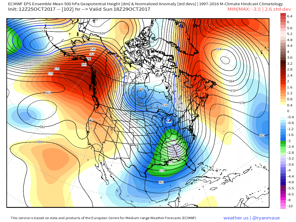
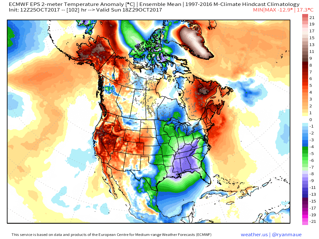 IV: Reinforcing Halloween Chill: We still stand firm on the idea of warm costumes being required this Halloween as chilly reinforcements blow into town Monday night. This will result in Halloween featuring a high in the mid to upper 40s with lows Tuesday night/ Wednesday morning dipping to around freezing (upper 20s in outlying areas away from the metro). Most of Trick-or-treat hours should feature temperatures in the upper 30s and lower 40s.

Permanent link to this article: https://indywx.com/2017/10/25/wednesday-evening-weather-notebook-frost-on-the-pumpkin-tonight/
 Highlights:
 Highlights:
 Despite an active weather week ahead, the open to the new work week will be rather uneventful. Weak high pressure will keep us dry today and Tuesday. Fog and low clouds should give way to an increasingly bright sky by this afternoon (still more clouds than sun today) and partly cloudy skies Tuesday.
 A stronger storm will impact the region as we close out the work week. Strengthening low pressure will track into the Great Lakes and drag a trailing cold front through our region Friday evening. A briefly milder southwesterly air flow will push temperatures close to 60° Friday afternoon/ evening before the sharply colder push of air blows into town for the weekend. The transition may include strong to severe thunderstorms Friday PM, and the Storm Prediction Center (SPC) has outlined a large portion of the region under a severe risk Friday. It’ll be important to stay tuned to future updates. Even outside of potentially damaging thunderstorm gusts, non-t-storm winds will gust over 40 MPH Friday.
 Once the cold front sweeps through the region, a sharply colder air mass will plunge into the Ohio Valley for the weekend. Overnight data has trended even colder and would suggest falling Saturday temperatures (most of the day will be spent in the 30s) and highs only in the lower to middle 30s Sunday.
 Speaking of cold, Thanksgiving week is looking unseasonably cold, and there’s also the potential of early-season snow (far too early for specifics).
 Highlights:
 Highlights:
 Highlights:
 Highlights:
 Highlights:
 II. Gusty Thursday: After a cold, calm start to our Thursday, southerly winds will become gusty late in the afternoon. This is a result of an approaching cold front that will impact the region Friday.
 III. Unseasonably Cold Weekend: A cold front will pass Friday afternoon and a band of showers will accompany the frontal passage. Winds will shift to the northwest late in the day and drive in a sharply colder close to the work week. Air will grow cold enough to potentially support snow to mix in with the rain as precipitation comes to an end. Additionally, upper level energy and the colder air mass this weekend (the air will have a bite to it) could support mixed rain and snow showers Sunday. – Novelty stuff only, but those first flakes are always special to see. Nonetheless, temperatures will run well below normal. In fact, highs will be closer to our average low temperature this weekend.
 IV: Reinforcing Halloween Chill: We still stand firm on the idea of warm costumes being required this Halloween as chilly reinforcements blow into town Monday night. This will result in Halloween featuring a high in the mid to upper 40s with lows Tuesday night/ Wednesday morning dipping to around freezing (upper 20s in outlying areas away from the metro). Most of Trick-or-treat hours should feature temperatures in the upper 30s and lower 40s.