Updated 05.06.24 @ 7:40a A busy stretch lies ahead tomorrow and Wednesday as we’re tracking the potential and likelihood of multiple rounds of strong to severe thunderstorms. This will all…
You must be logged in to view this content. Click Here to become a member of IndyWX.com for full access. Already a member of IndyWx.com All-Access? Log-in here.
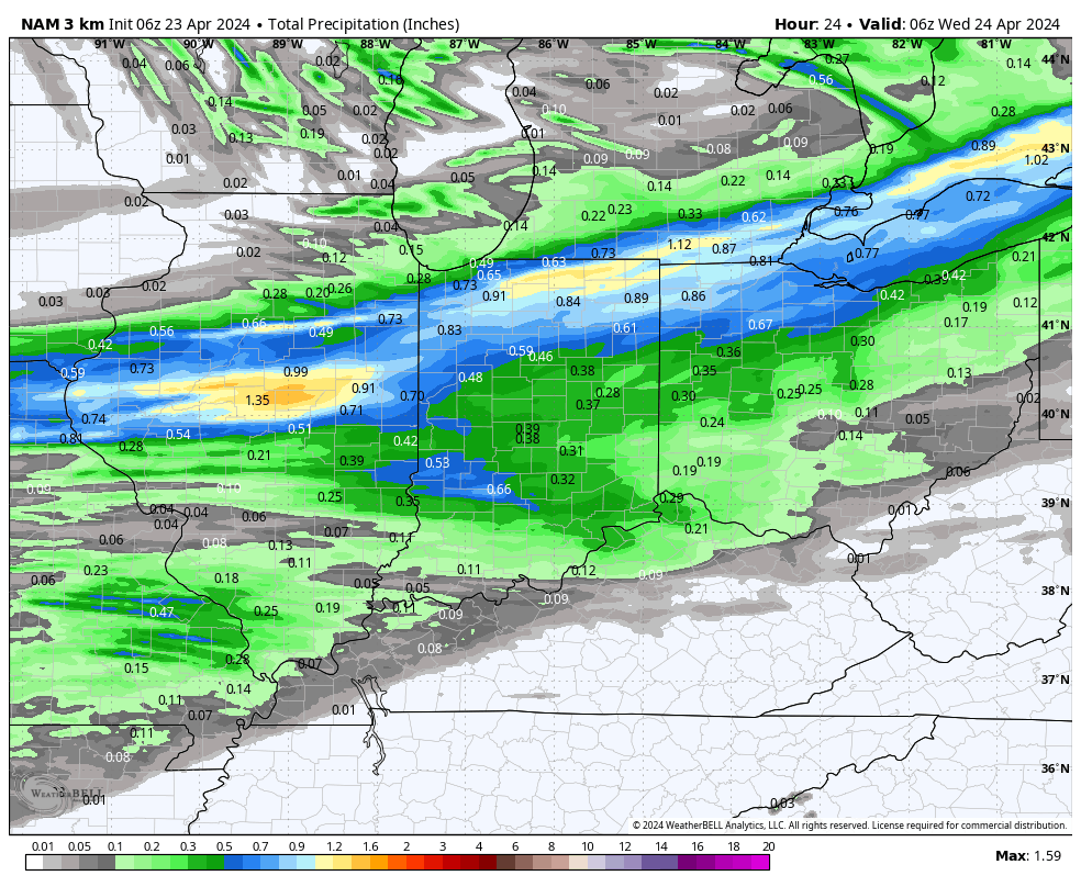
The day is dawning quiet but that will change as we move through the afternoon. Not only will rain increase in coverage and intensity, but winds will pick up out of the southwest. A wind-whipped rain will greet commuters on the way home this evening.
Rain will overspread central IN later this afternoon into the evening.
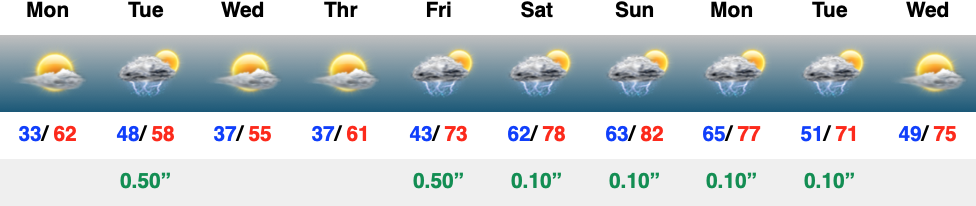
Most local rain gauges should accumulate 0.35″ to 0.50″ with the passage of this cold front.
As mentioned, winds will be strong and gusty today. We’ll top out with gusts upwards of 40 MPH across the region- perhaps even a bit stronger in spots.
High pressure will settle overhead midweek, allowing for clearing skies, diminishing wind, and cooler temperatures.
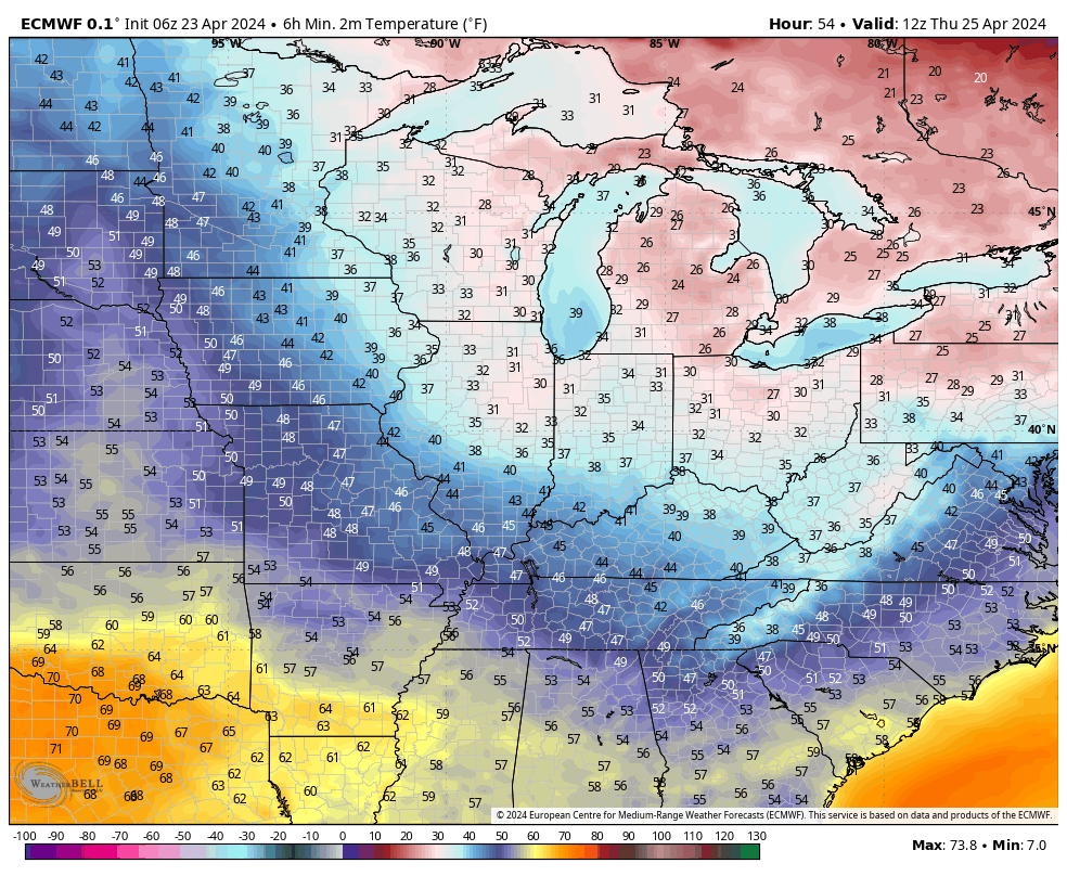
Additional chances of patchy frost can be expected around the greater Indy area by Thursday morning. Outlying areas away from the city, itself, can expect to dip into the lower to middle 30s Thursday morning with widespread frost.
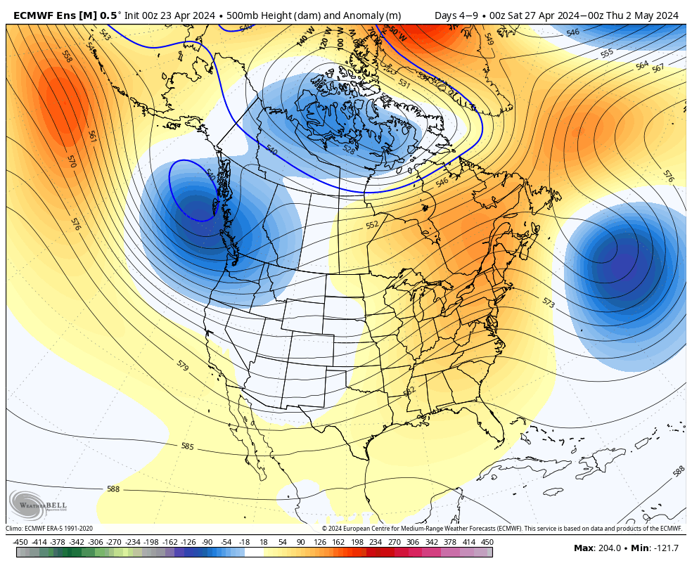
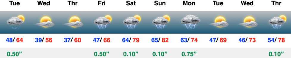
As we look ahead to the weekend and early next week, our region will undergo a regime change. Warmer, increasingly muggy air will replace the cool, stable air of midweek and storm chances will also increase. As of now, it looks like wettest days, including most widespread storms, will come Friday and Monday. While you’ll note storms in the forecast “box” below for Saturday and Sunday, it’s important to reiterate these will likely be few and far between (“splash and dash” variety). Most of the weekend is looking dry as of now.
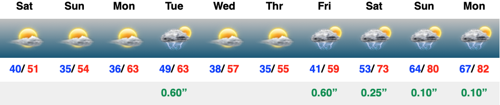
The work week will start pleasant but take an unsettled turn rather abruptly Tuesday. Clouds will increase and give way to showers and embedded thunder ahead of another unseasonably cool push of air just in time for midweek. The other item of note Tuesday? Strong southwesterly winds upwards of 40 MPH at times ahead of that cold front.
More of a true spring-like pattern takes hold going into the weekend, complete with increasing storm chances.
High pressure will dominate our weather this weekend, allowing for an extended dry, but cool stretch. Sunshine can be expected both today and Sunday and the overall pleasant theme will continue into the early stages of the new work week. Rain and storm return Tuesday and again on Friday of the week ahead. It’s just the beginning of another wet stretch as we close out April and head into May…
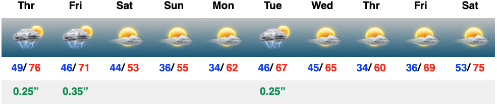
The day will start off quiet, but won’t end that way. We’re monitoring the threat of strong to severe storms later this evening, continuing into and through the overnight hours. The good news? All of these will be off to our east prior to heading out the door to work or school Friday morning. Then we can concentrate on a refreshingly cool weekend with sunshine returning.