Category: Windy

Confidence Growing In Potential Major Winter Storm…

Confidence continues to grow in the prospects of a major winter storm impacting the Mid West and Ohio Valley Friday into Saturday.  A cold front will slip through central Indiana Thursday night, allowing colder air to push back into the state.  At the same time, surface low pressure should begin to organize along the tail end of the frontal boundary across the Ark-la-tex region.  As we progress through the day Friday, cold air will continue to penetrate south into the Ohio Valley while the surface low lifts northeast into the region.  While we can argue about the specific track (this is still a few days out, after all), the pattern supports a central Ohio Valley track as we progress through the day Friday into Saturday.
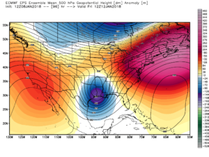
EPS 500mb ensemble mean Friday
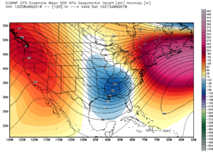
EPS 500mb ensemble mean Saturday
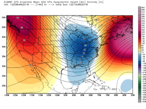
EPS 500mb ensemble mean Sunday

We caution not to get too worked up over individual operational output (including those “spectacular” runs) as run-to-run variance is likely over the next few days.  That said, when we have support from overall pattern techniques that have supported a significant interior event for late this week since last week, along with ensemble agreement, it does lead to greater than normal confidence.  If you have travel plans late this week/ weekend, we suggest keeping a very close eye on the forecast.  This will be a high impact event for portions of the Ohio Valley.

While it’s impossible to say precisely where the heaviest swath of snow is laid down in this situation from a few days out, this is a storm that should carry a swath of 6″ to 12″+ snow just to the northwest of the track.  Additionally, an initial period of an icy mixture of sleet and freezing rain is also possible.  Finally, as the storm wraps up over the Ohio Valley Saturday, a strengthening wind will lead to potential severe blowing and drifting issues.  Fresh arctic air will flow into the region Saturday night into Sunday that will return sub-zero wind chills to the area.

Bottom line, stay tuned…

Permanent link to this article: https://indywx.com/2018/01/08/confidence-growing-in-potential-major-winter-storm/

Busy, Busy, Busy…

Highlights:

  • Messy wintry mix arrives tonight
  • Briefly milder midweek
  • Potential storm brewing Friday

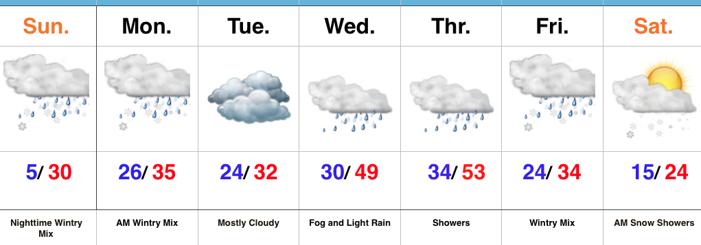
Snow And Ice Arrive Tonight…Clouds will lower and thicken across the state as we progress through the day.  We’ll also note a stiff easterly breeze as an approaching storm system inches ever so much closer.  This storm system will spread a wintry mix through the state tonight into early Monday morning.  Initially, we think most of central Indiana will deal with snow before a transition to freezing rain during the overnight, continuing into Monday morning.  Before the transition, 1″ to 2″ of snow seems to be the best idea before an icy glaze develops atop the freshly fallen snow.  Based on the expected transition to freezing rain, there’s an opportunity for up to a tenth of an inch of freezing rain.  That said, we’ll have to keep a very close eye on temperature profiles this evening as even the difference of a couple of degrees aloft can make all the difference in a faster or slower transition to freezing rain.  Expect the Monday morning commute to be heavily impacted.

Colder air will push back in here Monday evening into Tuesday with considerable cloudiness remaining.  A milder southerly flow will overtake the region Wednesday into Thursday.  Low clouds and fog along with drizzle will develop Wednesday and we may have to deal with a touch of freezing drizzle early in the day before temperatures rise.  A spike in temperatures will take place Thursday, briefly sending central Indiana into the 50s before a cold front slides through the state Thursday evening.

An area of low pressure will develop along the southern end of the frontal boundary and lift northeast into the TN Valley and eastern Ohio Valley Friday.  As colder air presses into the region, precipitation will change from a wintry mix of sleet and freezing rain to all snow through the day Friday.  It’s far too early to get specifics around accumulation ideas, but this storm has potential to be significant.  Much colder air will whip in here next weekend.

Upcoming 7-Day Precipitation Forecast:

  • Snowfall: 2″ – 4″
  • Rainfall: 0.50″ – 0.75″

Permanent link to this article: https://indywx.com/2018/01/07/busy-busy-busy/

VIDEO: Snow Develops Today With A Fresh Punch Of Arctic Air On Deck…

Light snow will develop today along with gusty winds and reinforcing arctic air to follow. Attention remains on Sunday into Monday…

You must be logged in to view this content. Click Here to become a member of IndyWX.com for full access.  Already a member of IndyWx.com All-Access?  Log-in here.

Permanent link to this article: https://indywx.com/2018/01/03/video-snow-develops-today-with-a-fresh-punch-of-arctic-air-on-deck/

Snow Develops Wednesday; Renewed Arctic Air…

Highlights:

  • Wednesday powder
  • Fresh batch of arctic air
  • Messy late weekend storm

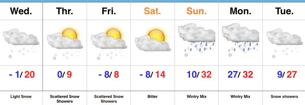
Snow Develops Wednesday Afternoon…Upper level energy will move across the region Wednesday and result in snow overspreading the northern half of the state (especially from Indianapolis and points north) during the afternoon and evening.  While snowfall amounts won’t be particularly impressive (generally 1″ or less), roads will likely get slick in relative quick fashion prior to the evening drive.  You’ll want to leave extra time on your evening commute home.  Otherwise, blowing and drifting snow will develop tomorrow night into Thursday as fresh arctic air pours into the area.

Attention will shift to lake effect snow across northeastern portions of the state Thursday before another ripple of energy drops southeast and sparks additional snow showers across central parts of the state to wrap up the work week.  Saturday will be dry and very cold.

Clouds will be on the increase overnight Saturday into Sunday morning and a mixed bag of precipitation will overspread the region Sunday PM.  We still have a few more days to watch things unfold, but concern remains for an icy cocktail of sleet and freezing rain after a potential initial burst of snow.  While warm air advection (WAA) will likely win out, we’re afraid it’ll be very difficult to warm the surface enough to prevent ice from becoming an issue Sunday afternoon into early Monday.  Cold air will sweep back in here Monday evening into Tuesday with snow showers and gusty winds.

Upcoming 7-Day Precipitation Forecast:

  • Snowfall: 1″ to 3″
  • Rainfall: 0.10″

Permanent link to this article: https://indywx.com/2018/01/02/snow-develops-wednesday-renewed-arctic-air/

Additional Snow Overnight; Dangerous Cold Grips The Region…

Highlights:

  • Blowing and drifting issues
  • Snow returns late tonight
  • Prolonged stretch of severe cold

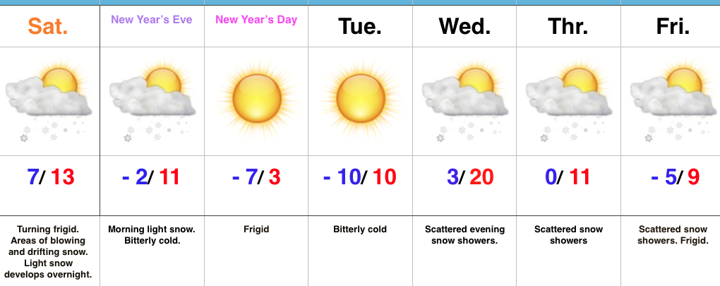
Bundle Up; Snow Returns Overnight…Yesterday’s snow event went as planned and many Hoosiers are waking up to several inches of powder this morning.  The winners yesterday stretched from Frankfort to Elwood to Winchester with a 6″ to 7″ band of snow.  All of that fresh snow will be blown and drifted about today with strong and gusty northwest winds.  If your travels take you into the open country, plan on significant blowing and drifting and leave extra time to reach your destination.

Additional upper level energy will scoot across the region late tonight into early Sunday and this will help kick up an area of light snow for central and southern portions of the state as we head into New Year’s Eve.  With the arctic air mass in place, don’t be surprised if we squeeze a quick inch out in spots.

Otherwise, the big story is the prolonged nature of this severe cold.  At times, wind chill values will drop to more than 30° below zero through early week.  Take the frigid conditions seriously.  Reinforcing arctic air will pour in here late next week and lead to scattered snow showers along with a bitter feel after slight midweek “moderation.”

Upcoming 7-Day Precipitation Forecast:

  • Snowfall: 1″ to 3″
  • Rainfall: 0.00″

Permanent link to this article: https://indywx.com/2017/12/30/additional-snow-overnight-dangerous-cold-grips-the-region/

Plowable Snow Event Gives Way To Dangerous Cold…

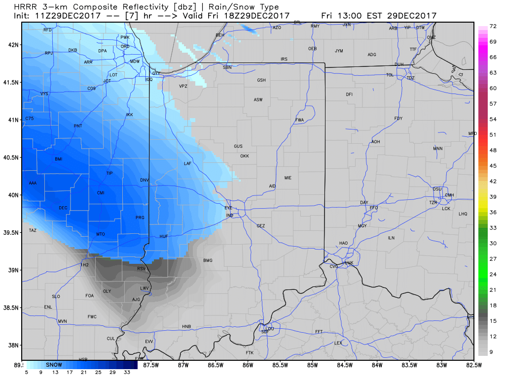
A quick-moving, but efficient clipper system will scoot across the Ohio Valley as we wrap up the work week and head into the weekend.  This will spread a swath of accumulating snow through central and northern IN this afternoon into early Saturday morning.

We forecast snow to start flying for the city, itself, around 1p to 2p.

Snow will then encompass most of the state as we progress into the late afternoon and evening hours.
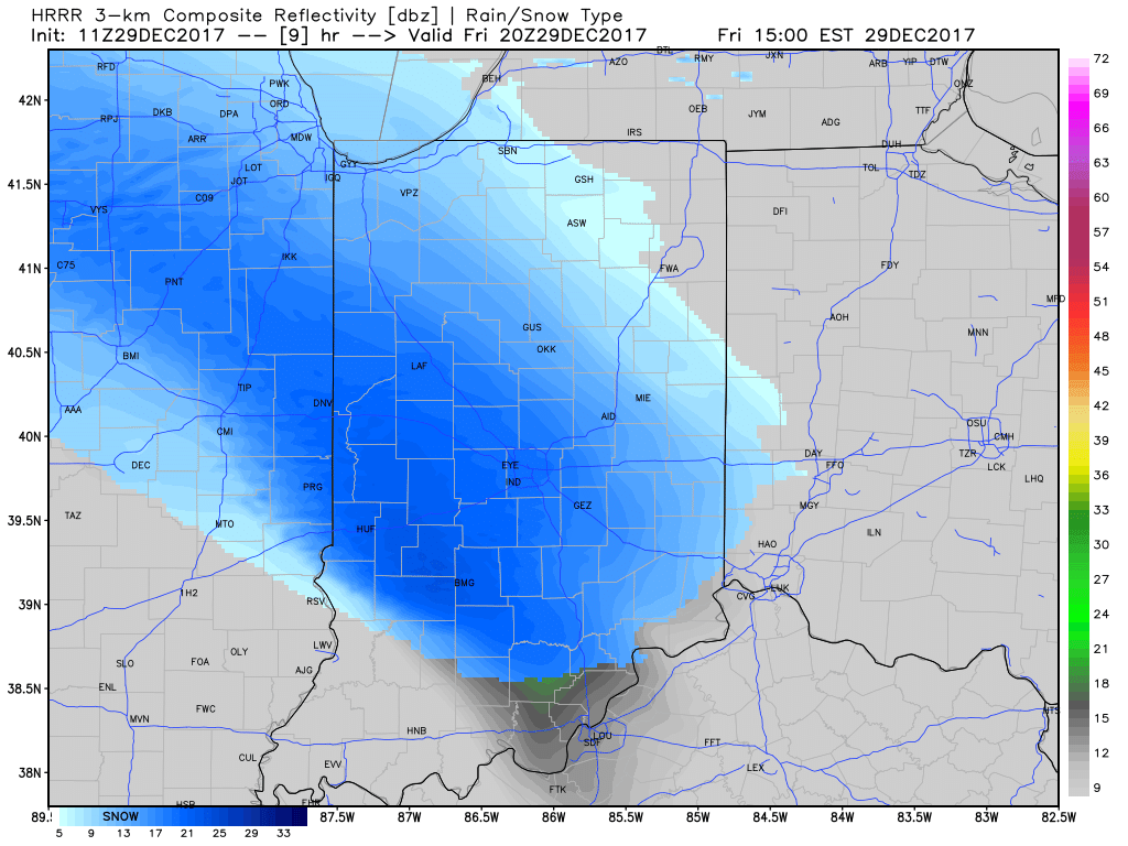
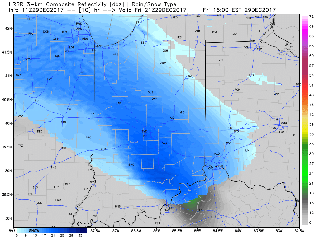
At times, we expect moderate snow to be falling across central Indiana and this will, unfortunately, make for a messy evening commute.  Plan for snow covered and snow packed roads and slick conditions.  Leave extra time to reach your destination.
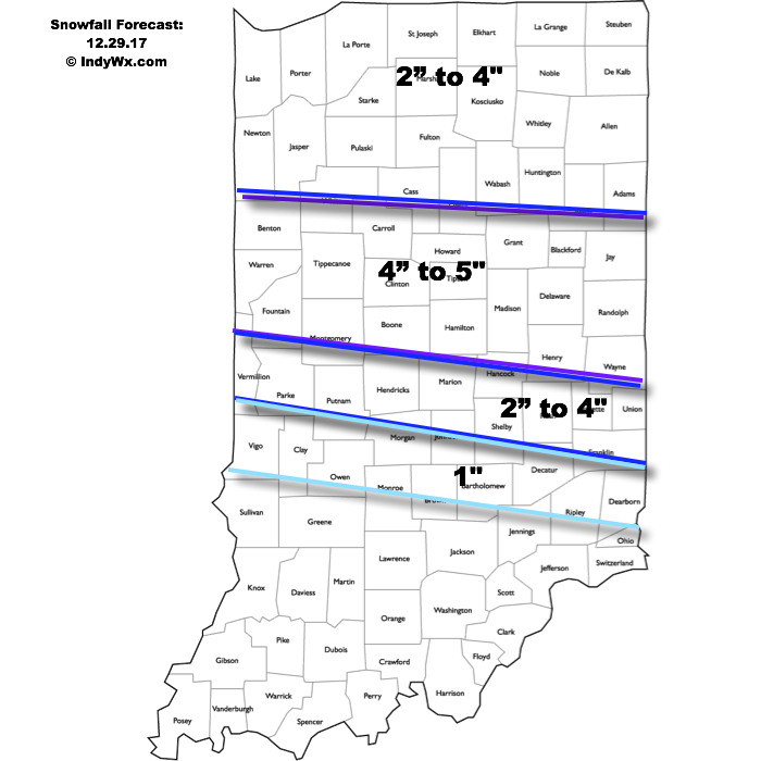
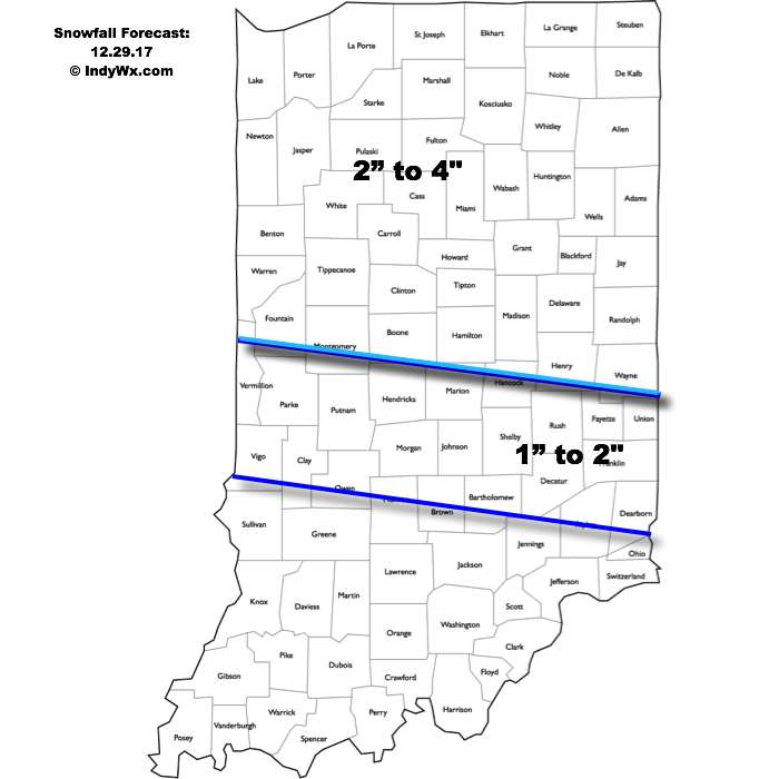
While snow showers will continue Saturday morning, most of the accumulating snow will fall before sunrise Saturday and here’s our updated accumulation forecast:

Attention once to Saturday will shift to the problems associated with blowing and drifting snow as winds increase and temperatures tumble.  Strong and gusty northwest winds will continue into early next week and not only will this lead to continued issues with blowing and drifting, but will also drive dangerously cold air into the area.
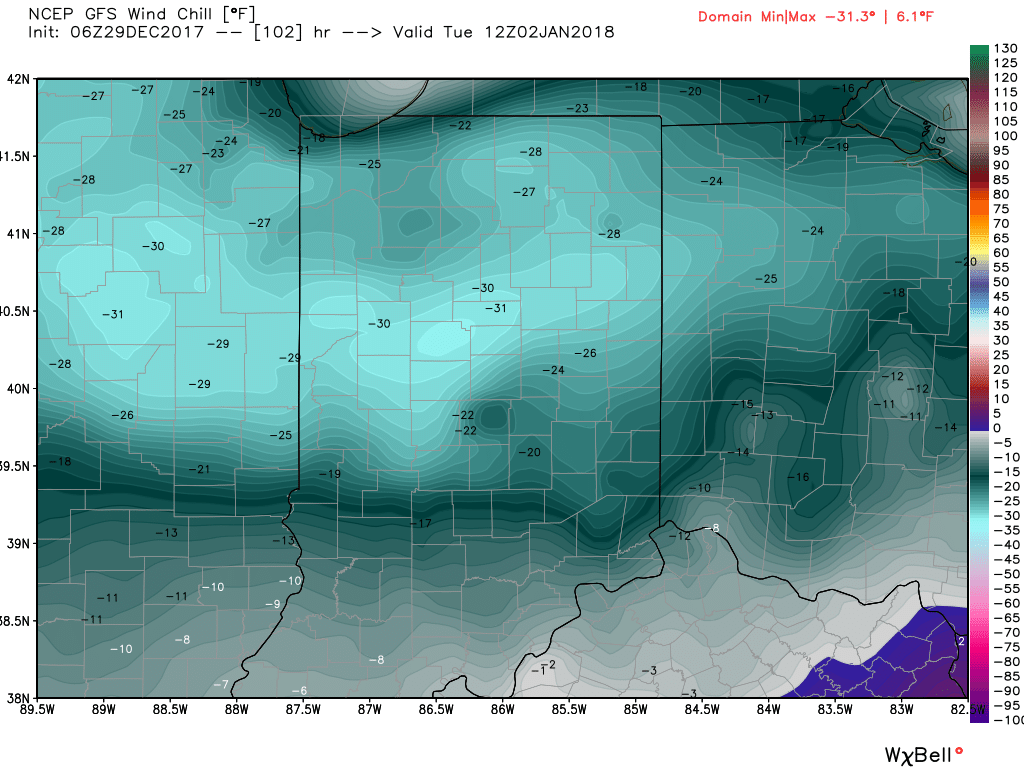
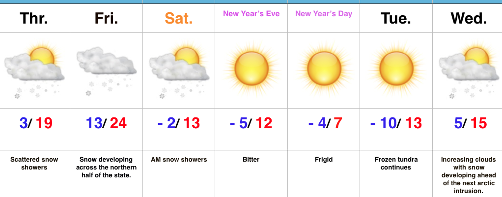
Here’s a look at our forecast lows over the next few mornings:

  • Saturday morning (12.30.17): 13° (falling through the day)
  • Sunday morning (12.31.17): 4° below zero
  • Monday morning (01.01.18): 6° below zero
  • Tuesday morning (01.02.18): 10° below zero

Not only will we have to deal with an extended stretch of subzero lows, but winds will combine to add further danger to the extreme weather.  Most of central and northern portions of the state will have to deal with 25° to 35° below zero wind chill values Tuesday morning.  Plan and prepare now.

Permanent link to this article: https://indywx.com/2017/12/29/plowable-snow-event-gives-way-to-dangerous-cold/

Accumulating Snow Friday; Dangerous Cold Develops Next Week…

Highlights:

  • Accumulating snow on the way
  • Frigid times remain
  • Dangerously cold next week

Snow And Major League Cold On Deck…A weak impulse of energy will track across the region today and will be just enough to ignite a couple of snow showers and scattered flurries.  For most, this won’t be a big deal.  A more impactful opportunity for accumulating snow will arrive Friday as a clipper system moves southeast.  Snow will develop late tonight across the Plains states before expanding in overall coverage and intensity as it pushes southeast into the Ohio Valley Friday.  With such cold air in place, snowfall ratios will be higher than the standard 10:1 and snow will quickly accumulate on roadways, making for slick travel Friday afternoon into the evening.  Here’s our current snowfall forecast for Friday:

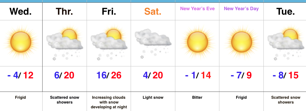
Snow showers will taper off Saturday morning and give way to a blustery, bitter day.  Temperatures will fall through the day and wind chill values will turn dangerous Saturday afternoon and evening (10° to 20° below zero).  This arctic intrusion will set us up for a frigid close to 2017 and open to 2018.  In fact, we expect severely cold conditions early next week (double-digit below zero readings, including wind chill values approaching 30° below zero at times).  Plan and prepare now.

Upcoming 7-Day Precipitation Forecast:

  • Snowfall: 2″ to 4″
  • Rainfall:  0.00″

Permanent link to this article: https://indywx.com/2017/12/28/accumulating-snow-friday-dangerous-cold-develops-next-week/

Snow Chances; Cold Only Grows Colder…

Highlights:

  • Frigid times
  • Snow chances return
  • Bitter open to 2018

Serious Cold…Arctic high pressure has settled over the region and combined with our snow cover to produce the coldest morning around these parts in a couple of years.  Some across central Indiana are awaking to double digit below zero readings.  Even the slightest breeze coupled with these bitterly cold readings creates dangerous conditions to spend time outdoors.

Cold is here to stay.  In fact, we’ll only grow more bitter next week.  If we can put snow down between now and then, there’s a good chance we’re not even cold enough early next week with forecast temperatures.  Speaking of snow, we’ll have to keep close tabs on impulses of upper level energy late tonight into Thursday for the potential of overachieving in the snowfall department (similar to what the I-70 corridor experienced Tuesday).  With arctic air in place, it doesn’t take much to get snow going.

We’re still expecting a more widespread snow event over the weekend.  We’re targeting Friday night into Saturday for light snow to overspread the region and this will setup a frigid close to the year and open to 2018.

Upcoming 7-Day Precipitation Forecast:

  • Snowfall: 1″ to 3″
  • Rainfall: 0.00″

Permanent link to this article: https://indywx.com/2017/12/27/snow-chances-cold-only-grows-colder/

VIDEO: Bitterly Cold; Watching Saturday Closely…

You must be logged in to view this content. Click Here to become a member of IndyWX.com for full access.  Already a member of IndyWx.com All-Access?  Log-in here.

Permanent link to this article: https://indywx.com/2017/12/26/video-bitterly-cold-watching-saturday-closely/

“It’s Beginning To Look A Lot Like Christmas…”

Highlights:

  • Wet snow today
  • New snow maker for Christmas Eve
  • Turning bitterly cold

Festive Forecast…Rain changed to wet snow for northwestern ‘burbs between 4a-5a and the transition from wet to white will continue to progress southeast through the morning.  A period of heavy, wet snow will fall through mid and late morning before precipitation begins to taper off.  Our going snowfall forecast from yesterday continues to work with this event (for most it’s a slushy coating to 1″ in and around Indianapolis, increasing to a couple inches north).  We experienced our high temperature for the day shortly after midnight.

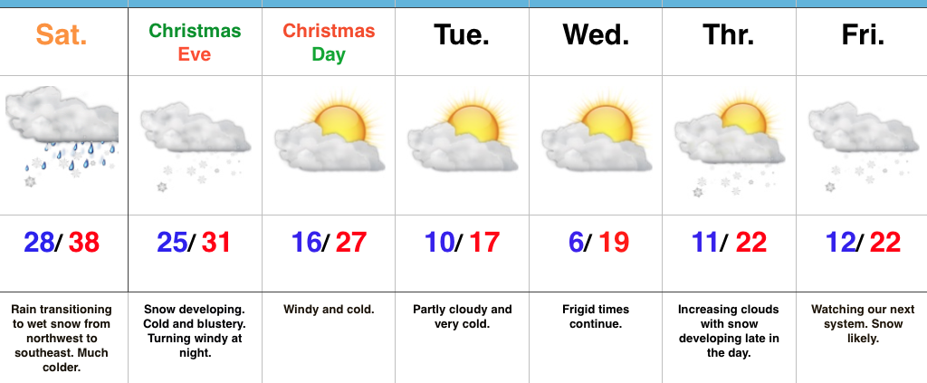
Attention will then quickly shift to a new snow maker arriving Christmas Eve.  The day will start dry, but snow will quickly develop as we progress into the afternoon.  At times, snow will come down at a moderate clip and provide a classic setting for your festivities tomorrow evening.  (We’ll have a fresh discussion posted later this afternoon for this event).  Travel safely and leave extra time to reach your destination, as snow will accumulate on roadways.  Additionally, we’ll add wind into the mix tomorrow night into Christmas Day with fresh cold air advection.

Speaking of Christmas, if you’re anticipating Santa to deliver outdoor gifts, you’ll want to plan to bundle up as you head out to enjoy the new toys.  It’ll be a dry, but very cold Christmas.

Cold will remain the weather word to sum up next week and we’ll target the end of next week for the potential next winter event.  It’s a busy, fun pattern if you like winter!

Upcoming 7-Day Precipitation Forecast:

  • Snowfall: 3″ – 5″
  • Rainfall: 0.00″

Permanent link to this article: https://indywx.com/2017/12/23/its-beginning-to-look-a-lot-like-christmas/

IndyWx.com