You must be logged in to view this content. Click Here to become a member of IndyWX.com for full access. Already a member of IndyWx.com All-Access? Log-in here.
Category: Windy
Permanent link to this article: https://indywx.com/2019/08/12/video-severe-weather-event-tonight-a-lot-of-noise-with-regard-to-the-late-august-pattern/
Jul 13
Barry Moves Inland; Pattern Progression Into Late July…
Tropical Storm Barry will make landfall today along the central LA coast as a strong tropical storm or hurricane (further strengthening is likely before making landfall later today). Gusts along the LA coast already this morning have reached 81 MPH. Once inland, the biggest concern with Barry’s remnants will come from a heavy rain and flooding situation. The heaviest rainfall will fall to the east of the center of circulation, encompassing central and eastern LA, western MS, eastern AR, and into western TN.

While Barry’s moisture will get into central Indiana early next week, we continue to believe the steady, heavier rainfall will remain across southern portions of the state. Overall, we don’t see any reason to alter our ongoing idea of where the heaviest axis of rain will set up shop. Tuesday into Wednesday appears to be the wettest period for the Ohio Valley from Barry. It’s possible a good portion of southern IN into central and southern OH receives 1″ to 2″ of rain with locally heavier totals during this time period. Understanding we’re talking about tropical remnants still roughly 72-84 hours away, some additional tweaking is likely to the forecast rainfall numbers.

Once Barry’s remnants exit to the east, the heat will be the big story for the 2nd half of the work week and into next weekend. Highs in the lower to middle 90s with overnight lows in the middle 70s can be expected as a ridge of high pressure expands over the region.

As we look beyond next week, the pattern should promote the axis of the ridge retrograding west. This would put the Ohio Valley in a more active northwest upper air flow, resulting in a backing off of the extreme heat and better rain/ storm chances as we progress through the last week of the month.
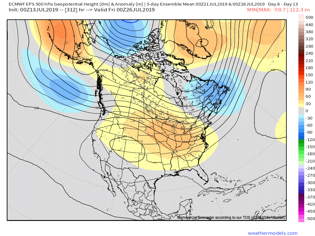
More later this afternoon with our video update! Enjoy your Saturday morning, friends.
Permanent link to this article: https://indywx.com/2019/07/13/barry-moves-inland-pattern-progression-into-late-july/
Jun 23
Bumpy Ride Possible This Afternoon And Evening…
While the weather is currently quiet across central Indiana, that will likely change in a significant way as we progress into the afternoon and evening hours.
As we look at the current radar, note the widespread showers and thunderstorms off to our southwest. More importantly, the latest couple of frames indicate a strengthening line of storms beginning to “bow” out along the eastern flank (along the MO/ IL state line).

The environment in place upstream into southern and central Indiana remains one that would tend to favor these storms strengthening further in the coming hours.
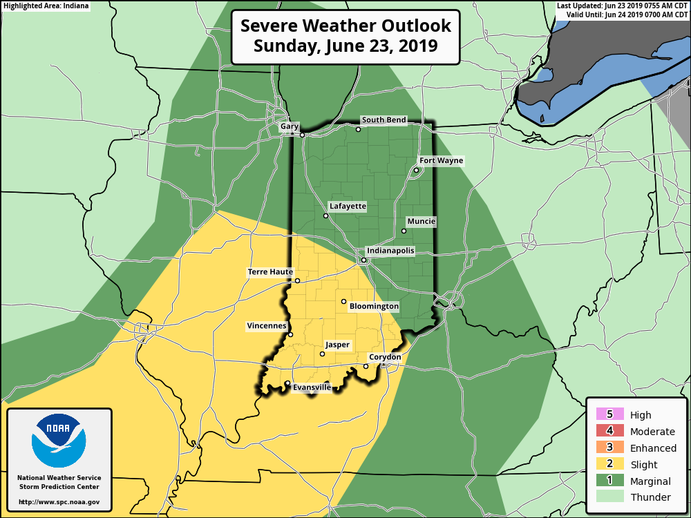
We note the Storm Prediction Center has nudge the Slight Risk further north to encompass more of southern and central Indiana with their latest update and we would agree with this.
We think storm coverage (and intensity) will really begin to ramp up after 3p and the latest HRRR shows this nicely:
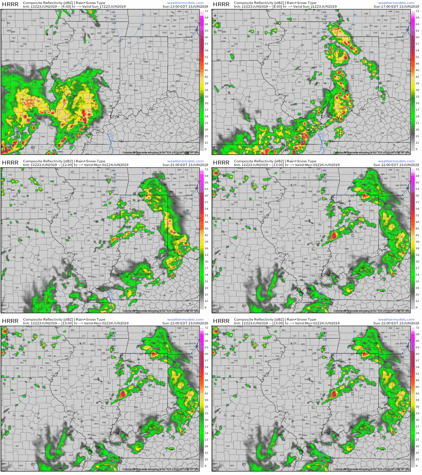
Greatest concern with any severe storms that develop has to do with strong and potentially damaging straight line winds. It’ll be important to remain weather-aware this afternoon into the evening hours.
*More later this evening, including our finalized July Outlook.
Permanent link to this article: https://indywx.com/2019/06/23/bumpy-ride-possible-this-afternoon-and-evening/
Jun 14
Friday Evening All-Access Video Update: A Wet, Stormy Weekend Awaits…
You must be logged in to view this content. Click Here to become a member of IndyWX.com for full access. Already a member of IndyWx.com All-Access? Log-in here.
Permanent link to this article: https://indywx.com/2019/06/14/friday-evening-all-access-video-update-a-wet-stormy-weekend-awaits/
Jun 05
VIDEO: Damaging Wind Potential With Storms This Evening; Quiet Close To The Week…
You must be logged in to view this content. Click Here to become a member of IndyWX.com for full access. Already a member of IndyWx.com All-Access? Log-in here.
Permanent link to this article: https://indywx.com/2019/06/05/video-damaging-wind-potential-with-storms-this-evening-quiet-close-to-the-week/
May 19
Stormy Evening Is Replaced With Cooler And Drier Air; Looking Ahead To The Busy Weekend On Deck…
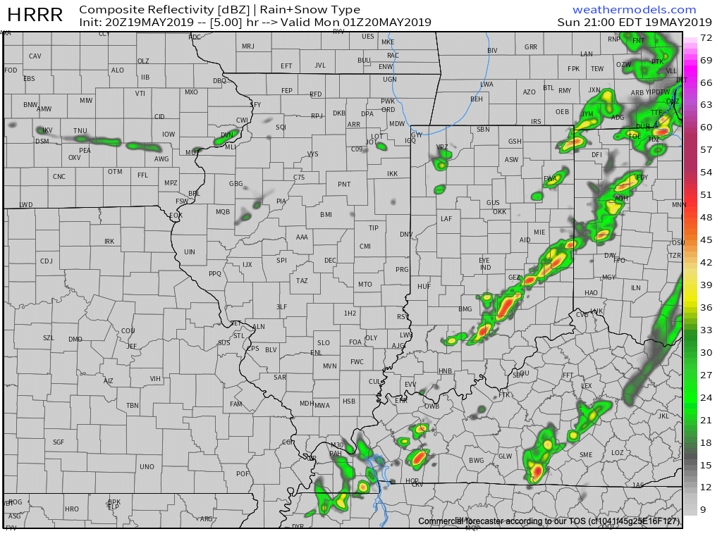
A line of strong to severe thunderstorms will continue to march east across the state this evening. As has already been the case, the primary concern with this line of storms will be damaging straight line winds and the NWS has been busy issuing warnings this evening.
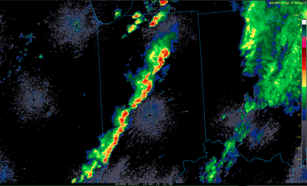
The line will pass into eastern Indiana over the next hour, or so, before weakening as it rumbles into Ohio.
Much cooler and drier air will work in overnight and you’ll certainly notice the difference out the door in the morning. Lows will fall into the lower 50s by morning. We’ll go even lower than that Tuesday morning with widespread middle 40s expected.

Resurgent warmth and humidity will make a return for the 2nd half of the week and with it will come that sultry feel. As a new heat ridge takes up residence across the region, storm systems will “flirt” with the area from time to time. Accordingly, we expect unsettled conditions not only for the 2nd half of the work week, but continuing into the Indy 500/ Memorial Day weekend. It certainly won’t rain and storm the entire time, but the threat for a passing storm at any time will be high.

More in the morning around the pattern evolution into early-June, but we continue to believe the MJO will have it’s say and that things will transition towards an eastern trough as we put a wrap on May and open June.
Permanent link to this article: https://indywx.com/2019/05/19/stormy-evening-is-replaced-with-cooler-and-drier-air-looking-ahead-to-the-busy-weekend-on-deck/
May 18
VIDEO: Hot Saturday Gives Way To Sunday Storms; Pattern Changes Ahead For Early-June…
A sunny, but hot Saturday is on deck before we introduce strong thunderstorms into the picture for the second half of the weekend. We also look ahead to the pattern…
You must be logged in to view this content. Click Here to become a member of IndyWX.com for full access. Already a member of IndyWx.com All-Access? Log-in here.
Permanent link to this article: https://indywx.com/2019/05/18/video-hot-saturday-gives-way-to-sunday-storms-pattern-changes-ahead-for-early-june/
May 16
VIDEO: Humid Air Inbound; Storms Flare Up Later Today For Some…
You must be logged in to view this content. Click Here to become a member of IndyWX.com for full access. Already a member of IndyWx.com All-Access? Log-in here.
Permanent link to this article: https://indywx.com/2019/05/16/video-humid-air-inbound-storms-flare-up-later-today-for-some/
Apr 24
VIDEO: Scattered Shower Chances Increase This Evening; Wet Pattern Develops Next Week…
You must be logged in to view this content. Click Here to become a member of IndyWX.com for full access. Already a member of IndyWx.com All-Access? Log-in here.
Permanent link to this article: https://indywx.com/2019/04/24/video-scattered-shower-chances-increase-this-evening-wet-pattern-develops-next-week/
Apr 18
VIDEO: Walking Through The Heavy Rain To Snow Transition Ahead This Weekend; Active Pattern Returns Early Next Week…
You must be logged in to view this content. Click Here to become a member of IndyWX.com for full access. Already a member of IndyWx.com All-Access? Log-in here.
Permanent link to this article: https://indywx.com/2019/04/18/video-walking-through-the-heavy-rain-to-snow-transition-ahead-this-weekend-active-pattern-returns-early-next-week/
