Category: Windy

All Worth It For This Kind Of Weekend…

Updated 03.19.21 @ 7:52a

The past week has dealt the region a couple of nasty storm systems. We had to deal with freezing rain to open up the work week. If that wasn’t enough, the big rain and wind storm yesterday led to flooding in low spots along with some downed trees across central Indiana (top wind gusts I’ve seen were in the 50-60 MPH) range. Given the saturated soils, it’s really a wonder we didn’t deal with more significant tree damage.

As low pressure departs to our southeast, high pressure will build overhead and support plenty-o-sun throughout the weekend. The pressure gradient will remain tight during this transfer of “power” today. Accordingly, ENE winds will continue to be quite gusty before diminishing by evening.

A couple gusts over 35 MPH will be likely through at least early afternoon.

Highs today will top out in the upper 40s for most with mostly sunny skies.
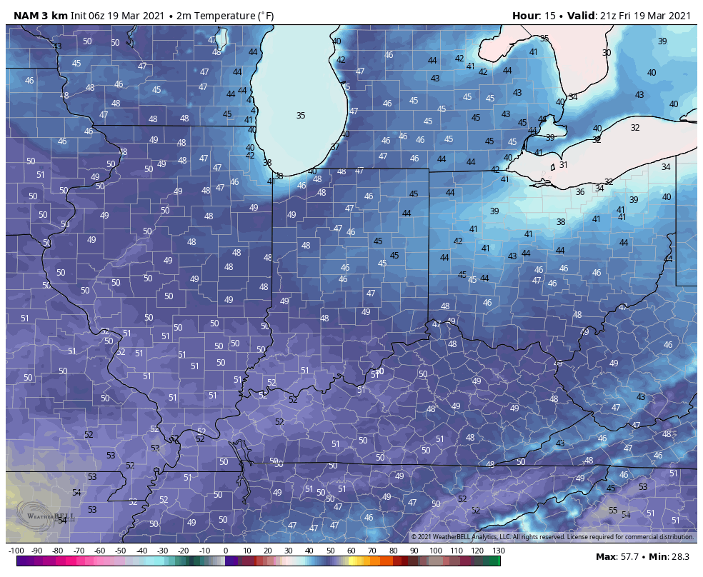
High pressure will dominate straight through the weekend and to open the new work week. Consequently, expect an extended stretch of sunshine along with moderating temperatures. We’ll top out in the lower to middle 60s by Sunday!
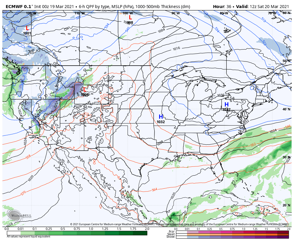
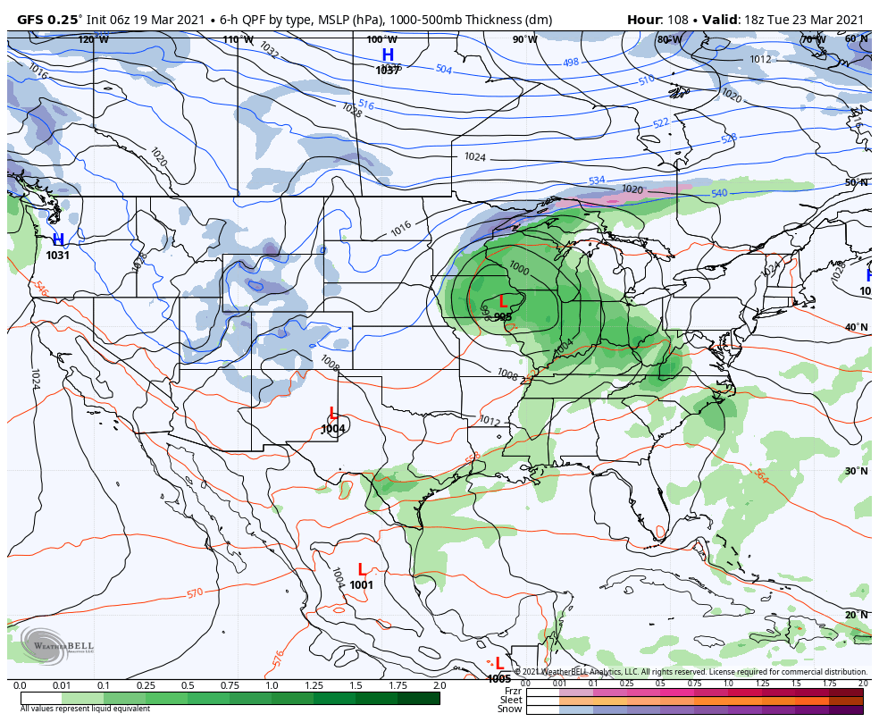
Our next storm system will arrive during the day Tuesday with thunderstorm potential. More on this throughout the weekend…
Permanent link to this article: https://indywx.com/2021/03/19/all-worth-if-for-this-kind-of-weekend/

VIDEO: Windy, Wet, And Raw Today; Gorgeous Weekend Awaits…

Updated 03.18.21 @ 7:43a

You must be logged in to view this content. Click Here to become a member of IndyWX.com for full access.  Already a member of IndyWx.com All-Access?  Log-in here.

Permanent link to this article: https://indywx.com/2021/03/18/video-windy-wet-and-raw-today-gorgeous-weekend-awaits/

VIDEO: So Long Boring Weather; Series Of Storm Systems Target The Region Over The Next Couple Of Weeks…

Updated 03.10.21 @ 7:54a

You must be logged in to view this content. Click Here to become a member of IndyWX.com for full access.  Already a member of IndyWx.com All-Access?  Log-in here.

Permanent link to this article: https://indywx.com/2021/03/10/video-so-long-boring-weather-series-of-storm-systems-target-the-region-over-the-next-couple-of-weeks/

VIDEO: Couple More Nice, Warm Days Before Changes Arrive…

Updated 03.09.21 @ 7:48a

You must be logged in to view this content. Click Here to become a member of IndyWX.com for full access.  Already a member of IndyWx.com All-Access?  Log-in here.

Permanent link to this article: https://indywx.com/2021/03/09/video-couple-more-nice-warm-days-before-changes-arrive/

VIDEO: Gorgeous Open To The Work Week Gives Way To More Unsettled Times Late Week…

Updated 03.08.21 @ 7:55a

You must be logged in to view this content. Click Here to become a member of IndyWX.com for full access.  Already a member of IndyWx.com All-Access?  Log-in here.

Permanent link to this article: https://indywx.com/2021/03/08/video-gorgeous-open-to-the-work-week-gives-way-to-more-unsettled-times-late-week/

02.22.21 Weather Bulletin: A Much Milder Week…

Updated 02.22.21 @ 8:15a

Gusty Out This Morning…Westerly winds are blowing at a good clip this morning, including gusts of 30-40 MPH. These will continue into the afternoon before diminishing. All in all, we’re looking at a much milder stretch of weather in the week ahead. Compared to the past couple of weeks, most days will be downright balmy. Sunshine will return tomorrow and remain with us through the day Friday. It continues to look like Wednesday night’s frontal passage will be an uneventful one.

As we look ahead to the weekend, shower chances return Saturday as a couple of systems team together. As of now, the northern and southern stream energy doesn’t look like it’ll phase until over the Northeast/ New England region. As such, this doesn’t look like a big deal here, but we’ll continue to keep an eye on things.

Averages: H: 43°/ L: 26° on the 22nd –> H: 45°/ L: 28° on the 28th

Permanent link to this article: https://indywx.com/2021/02/22/02-22-21-weather-bulletin-a-much-milder-week/

Client Brief: Periods Of Blizzard Conditions Tonight…

Updated 02.15.21 @ 1:18p

Type: Severe Winter Weather

What: Heavy snow & strong winds

When: Through Tuesday morning

Temperatures: Mid 10s, falling into the upper single digits by Tuesday morning

Wind: NE 15 – 25 MPH (gusts up to 35 MPH Monday evening)

Blowing/ Drifting: Severe  

Pavement Impacts: Plowing and salting will be required

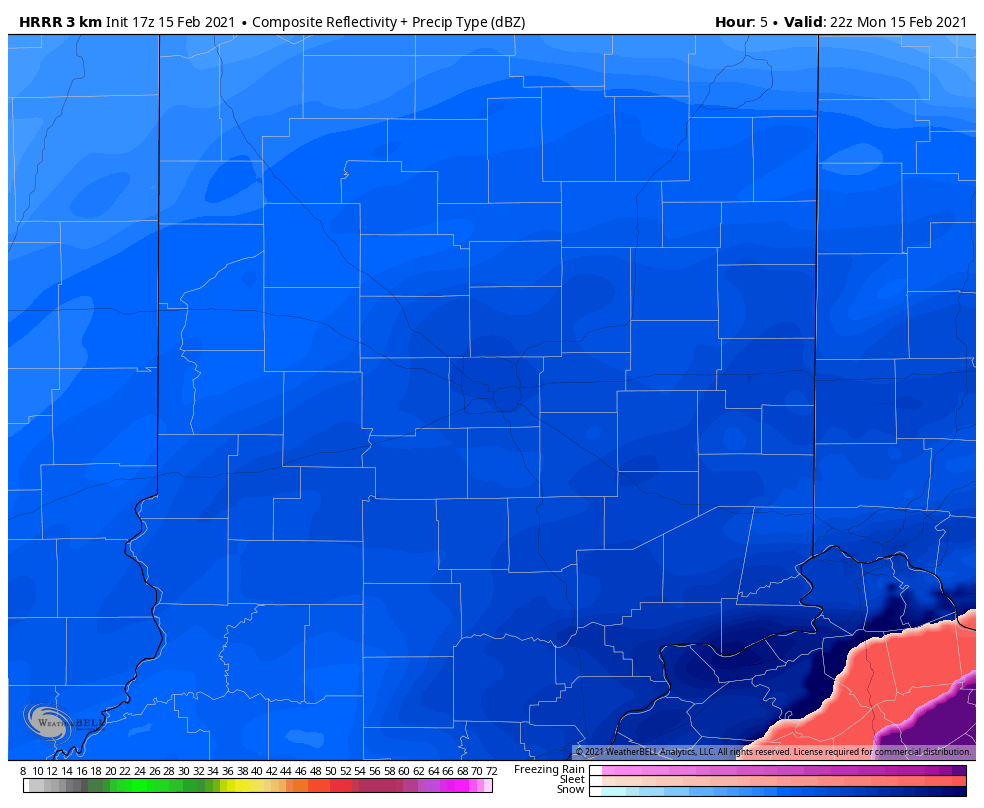
Summary: A shield of snow will encompass all of central Indiana through the afternoon and into the late evening hours. Snow will become heavy at times by mid and late afternoon, continuing through the evening hours, including snowfall rates of 1″ to 2″ per hour. As the area of low pressure draws closer this evening, northeast winds will strengthen and gust up to 35 MPH. Periods of whiteout conditions can be expected around, or just after sunset. Falling snow will end from south to north by midnight to 2a. Strong and gusty northerly winds will continue into Tuesday morning leading to severe blowing and drifting, especially in the open country. In these areas, drifts of 3 to 4 feet are expected.

Confidence: High

Next Update: This afternoon (video)

Permanent link to this article: https://indywx.com/2021/02/15/client-brief-periods-of-blizzard-conditions-tonight/

02.15.21 Weather Bulletin: Hunker Down…

Updated 02.15.21 @ 7:20a

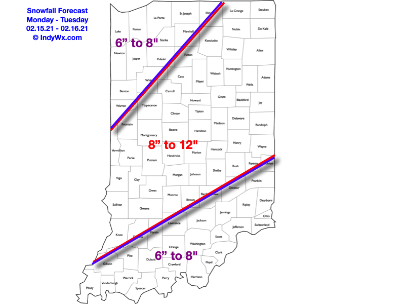
Be At Your Destination By Early Afternoon…Light snow continues to fall across the region this morning, but conditions will deteriorate rapidly as we move just beyond the lunchtime hour. Snowfall will become heavy and accumulate to the tune of 1″ to 2″ per hour this afternoon and tonight. By Tuesday morning, we expect many central Indiana communities to be closing in on a foot, and drifts in the open country will exceed 3 feet in spots. We highly discourage travel today if at all possible. If you have to travel this afternoon and evening, please ensure you have a winter storm survival kit packed as many roadways will become impassable due to a combination of very heavy snow and increasing wind. Speaking of wind, northeasterly gusts will top 35 MPH this evening, leading to severe drifting. Our snowfall forecast remains unchanged from yesterday.

Clean up from storm 1 should begin Tuesday morning as another winter storm has eyes on the region Wednesday night through Thursday. Despite a few lingering light snow showers Tuesday morning, a period of quieter conditions will develop for about 24 hours from Tuesday afternoon into Wednesday afternoon. Though it’ll still be much colder than normal, sunshine will return.

Our next storm system will come roaring out of the northwest Gulf Wednesday night, tracking northeast, up along the western slope of the Appalachians Thursday into Thursday night. You know the drill: this is a favorable track for another heavy snow storm and we expect adding several more inches onto our growing snowpack during this time frame. Stay tuned as we issue our snowfall forecast for Storm #2 later today.

Looking further ahead, it finally looks like we’ll climb out of the deep freeze by the 2nd half of the weekend. The problem? Another storm system will be approaching with snow and/ or a wintry mix.

Permanent link to this article: https://indywx.com/2021/02/15/02-15-21-weather-bulletin-hunker-down/

VIDEO: Roadways Become Impassable Tomorrow Evening From Combo Of Heavy Snow/ Severe Drifting; ANOTHER Strong Winter Storm Inbound Midweek…

Updated 02.14.21 @ 10p

You must be logged in to view this content. Click Here to become a member of IndyWX.com for full access.  Already a member of IndyWx.com All-Access?  Log-in here.

Permanent link to this article: https://indywx.com/2021/02/14/video-roadways-become-impassable-tomorrow-evening-from-combo-of-heavy-snow-severe-drifting-another-strong-winter-storm-inbound-midweek/

Client Brief: Snow Builds In Overnight; Becomes Heavy Monday Afternoon Into Monday Night…

Updated 02.14.21 @ 12:29p

Type: Severe Wintry Weather

What: Heavy snow & strong winds

When: Monday morning – Tuesday morning

Temperatures: 16° to 21°

Wind: NE 15 – 25 MPH (gusts up to 35 MPH Monday evening)

Blowing/ Drifting: Severe  

Pavement Impacts: Plowing and salting will be required

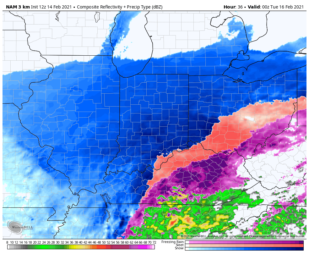
Summary: Light snow will overspread central Indiana during the overnight, continuing through Monday morning. As the surface low moves northeast (up the Appalachian chain), snowfall rates will increase Monday afternoon into Monday night, becoming heavy at times. The cold nature of this storm system will lead to an efficient snow producer, including rates that will likely top 1″ per hour at times Monday afternoon into Monday evening. As the low moves closer, the pressure gradient will tighten and lead to strengthening northeast wind gusts (up to 35 MPH) for a period of time after sunset into the late evening hours. Travel is highly discouraged tomorrow, especially by afternoon and evening as the combination of heavy snow and strong winds will likely lead to some roadways becoming impassable. Drifts in the open country will likely reach 3 to 4 feet by Tuesday morning. Snow will end from southwest to northeast Tuesday morning.

*Our other products issued later tonight will handle the expected additional significant impacts with Storm #2.

Confidence: High

Next Update: Tonight (video)

Permanent link to this article: https://indywx.com/2021/02/14/client-brief-snow-builds-in-overnight-becomes-heavy-monday-afternoon-into-monday-night/

IndyWx.com