Relatively Quiet Now, But It Won’t Last Long…

Enjoy our relatively quiet and briefly milder weather pattern as mid and long range guidance suggests we reload the cold with authority and associated wintry precipitation threats…

You must be logged in to view this content. Click Here to become a member of IndyWX.com for full access.  Already a member of IndyWx.com All-Access?  Log-in here.

Bitterly Cold Start, But Moderation On The Way…

Screen Shot 2015-01-14 at 7.58.43 AM

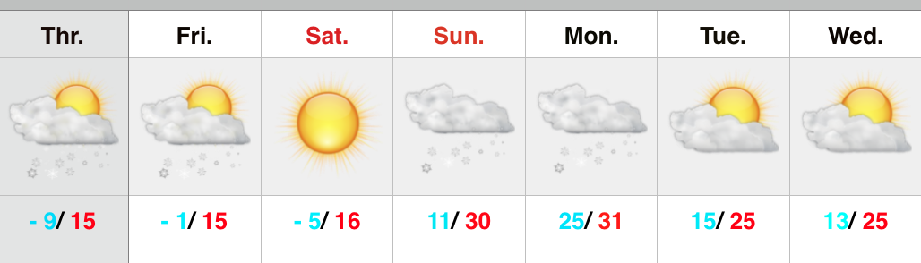
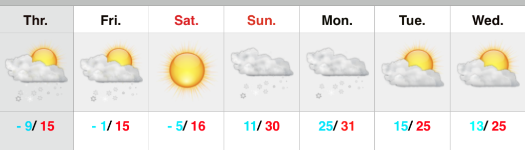
“Relaxation” Of The Bitterly Cold Pattern…That forecast package title sure wouldn’t suffice describing the weather outside this morning.  It’s a downright bitter feel, including below zero temperatures throughout north-central Indiana.  Patchy freezing fog and scattered flurries are also with us this morning.  With some sunshine later, we’ll “warm” into the lower 20s this afternoon.  A few flurries may fly tonight as a weak disturbance moves through the region.

Sunshine will be with us to wrap up the work week along with slowly moderating temperatures.  Average highs this time of the year are in the middle 30s so we’ll be closer to average Thursday and Friday- though it’ll likely feel much warmer simply based off just how cold it’s been as of late.  Gusty southwest winds will blow milder air in here briefly Saturday as temperatures climb into the middle 40s.

A cold front will sweep the state Sunday morning with a possible rain shower that’ll quickly transition to scattered snow showers as the colder air filters back into the region.  The next storm system of note arrives early next week.

Upcoming 7-day Precipitation Forecast:

  • 7-Day Snowfall Forecast: Dusting
  • 7-Day Rainfall Forecast: 0.10″ – 0.20″

Catching Up On Where We’ve Been And What Lies Ahead…

January is off to a frigid start. After a mild December, January is certainly reminding folks that there’s a lot of winter in this pattern. Precipitation is running above normal…

You must be logged in to view this content. Click Here to become a member of IndyWX.com for full access.  Already a member of IndyWx.com All-Access?  Log-in here.

Fresh Arctic Air Inbound; Winter Storm Potential Sunday Night-Monday.

Tonight’s video update discusses the heavier burst of snow inbound, fresh arctic air/ dangerous wind chill values Friday, and takes a look at more “wintry mischief” brewing for late in…

You must be logged in to view this content. Click Here to become a member of IndyWX.com for full access.  Already a member of IndyWx.com All-Access?  Log-in here.

Wind And Snow Arrives This Evening; Fresh Arctic Air Invades…

Screen Shot 2015-01-08 at 7.19.42 AM


Ready For More Wind And Snow?!  The day will dawn with sunshine and downright frigid temperatures.  Some numbers as of 7am include the following:

  • Zionsville: – 10
  • Eagle Creek: – 6
  • Indianapolis: – 6
  • Frankfort: – 10
  • Kokomo: – 8

Wind chill readings are obviously even colder (- 20 to -30).  Clouds will quickly increase as we progress into the afternoon hours and snow won’t be far behind.  We forecast a quick burst of heavier snow between 5-7p followed by snow showers through the evening.  Most folks from Indianapolis and points north will accumulate around an inch of new snow this evening.  Winds will also be very gusty and lead to all sorts of blowing and drifting concerns once again (of new snow and existing snow).

Temperatures will fall Friday and be in the single digits for most of the day before heading back below zero Friday evening/ Saturday morning.  Welcome to the frozen tundra! 🙂

Our next winter event of significance will press in Sunday.  Clouds will lower and thicken through the day and snow should develop by evening.  Light snow and potentially a wintry mix will continue Sunday night into the day Monday.  Stay tuned!

Upcoming 7-Day Precipitation Forecast:

  • 7-Day Snowfall Forecast: 2″ – 4″
  • 7-Day Rainfall Forecast: 0.00″