Sustained Frigid Pattern…
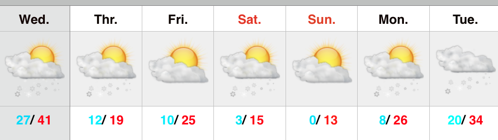
 Arctic Reinforcements…That will be theme of the upcoming 7-days as one arctic blast after another drops into the region. Considering normal highs are in the upper 30s and lows are in the lower 20s, the majority of days this upcoming week will feature highs colder than our average low. – Impressively cold both from the absolute temperature, but also the sustained nature.
Today’s arctic attack will be preceded by snow showers and squalls (dusting to less than 1″), strong and gusty winds up to 45 MPH, and dangerous wind chills by afternoon and evening to between 15 and 20 degrees below zero.
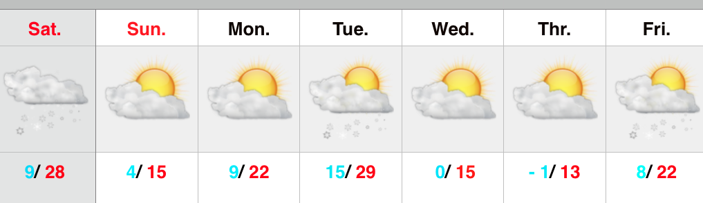
We continue to keep an eye on a southern winter storm early next week, but details remain far from etched in stone on the track of the system. Nearly all guidance keeps snow south of our region, but we note the overall pattern is one that may promote a northward shift in the system over the next day or two. Is a big snow in our future? No, but we can’t completely remove the chance of light snow just yet Tuesday.
Yet another arctic blast will drop into town by the middle of the week and that may be the coldest yet…
Upcoming 7-Day Precipitation Forecast:
- 7-Day Snowfall Forecast: 1″
- 7-Day Rainfall Forecast: 0.00″