Changes On The Horizon…
Screen Shot 2015-11-08 at 9.39.59 AMHighlights:

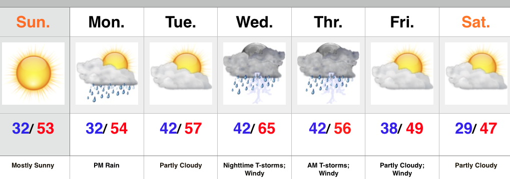
  • Beautiful Sunday
  • Rain arrives Monday afternoon/ evening
  • Stormy Wednesday night-Thursday morning
  • Much colder late next week

High pressure will supply a beauty of a second half of the weekend.  After the frosty start to the day, we’ll “warm” into the lower 50s this afternoon.  It’ll be a perfect crisp November day.

Changes arrive Monday as clouds increase and give way to rain as early as the afternoon as moisture rides north out of the Deep South.  A wave of low pressure will ride up the western slopes of the western Appalachians and enhance early week rain to our east.

The next big ticket item is the storm that will arrive Wednesday night.  We continue to keep a very close eye on this as a severe weather outbreak appears likely.  Specifics still have to be ironed out and we go through the next couple days, but keep abreast of the latest weather information during the Wednesday night-Thursday morning time period.

MUCH colder air will pour into the region behind the big low as it wraps up over the Great Lakes.  A hard freeze appears likely come Saturday morning.

Upcoming 7-Day Rainfall Forecast:  0.50″ – 1″
Dry, Chilly November Weekend; Mid Week Storms…

Screen Shot 2015-11-07 at 10.56.54 AMHighlights:

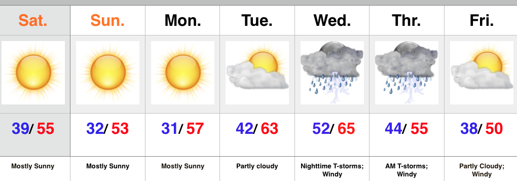
  • Sunny and cool
  • Midweek Storms
  • Prolonged period of windy weather late week

High pressure is building into the Ohio Valley this weekend and helping supply sunshine and that cool, crisp air we enjoy this time of year.  Freeze and frost conditions are ahead tonight and again Monday morning as high pressure moves overhead and results in clear skies and calm winds.

As the high moves to our east, a return SW flow will help moderate temperatures for mid week. As our next storm system comes out of the Plains it’ll intensify as it tracks into the Great Lakes.  Thunderstorms will accompany the cold front as it swings through the state Wednesday night.  We’ll monitor for strong to severe storm potential.  A lot will hinge upon the precise track of the surface low and we’ll keep a close eye on things over the next couple days.  We’ll turn cooler again late next week with strong winds shifting from the SW to NW.

Upcoming 7-Day Rainfall Forecast: 0.50″

Gusty Storms Followed By November Chill…

Screen Shot 2015-11-04 at 9.55.56 PMHighlights:

  • One more warm day
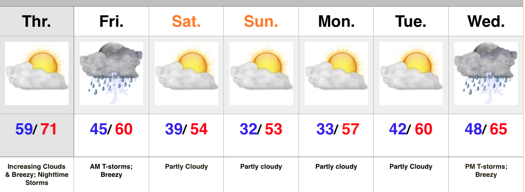
  • Gusty storms late tonight-Friday morning
  • Feeling more seasonal this weekend
  • Next storm arrives at the end of the period

High pressure will give way to an approaching cold front tonight.  Variably cloudy skies this morning will turn increasingly cloudy as the afternoon/ evening progresses.  Gusty SW winds will increase and gust over 20 MPH by afternoon.

The cold front will move through central IN early Friday morning and be preceded by a line of showers and embedded thunderstorms.  A few of these storms may contain strong winds, and this potential is something we’ll continue to keep a close eye on through the day Thursday.  Beneficial rains will also accompany the frontal passage.

The big story going into the weekend will be a much cooler, more seasonable feel, but sunshine will also be in our forecast.

Our next storm system of note appears to have eyes on the region by the middle of next week.

Upcoming 7-Day Rainfall Forecast: 0.5″ – 1″

Unseasonably Warm Open To November…

Screen Shot 2015-10-31 at 8.56.22 AMHighlights:

  • Windy and showery Halloween
  • Dry time returns with warmth
  • Watching a more substantial storm at the end of the week

Good morning and happy Halloween, friends!  We’re off to a cold and blustery start.  Temperatures in the 40s, along with a stiff east breeze is presenting a chill in the air!  A rather gloomy day is on deck with “showery” conditions at times, but there will be more dry time than not.

The second half of the weekend will turn brighter and very pleasant, and this will really set the tone for what will be a very tranquil first few days of November (where is time going)?!  Unseasonably warm conditions will be with us for the balance of the upcoming work week and provide a great opportunity to get those yard chores taken care of or Christmas lights put up.

A more substantial storm system will arrive late week with showers and thunderstorms followed by colder air next weekend…

Upcoming 7-Day Rainfall Forecast: 0.50″ – 1″