Winter Finally Shows Up…
 Highlights:
- Much colder than average
- Snow prospects to open the week
- Busy pattern continues
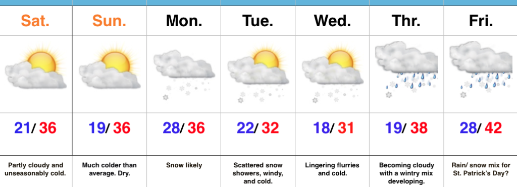
Locked In A Cold Pattern…The stretch of spring-like, unseasonably warm, conditions we enjoyed through most of February and to open March will be all but a distant memory once to this time next week. A major reversal to a colder than normal pattern is now with us and will feature lows into the teens on a few nights over the upcoming week.
Additionally, we continue to highlight the fast-moving northwest flow aloft. This kind of regime wrecks havoc on forecast models and, accordingly, we have lower than normal confidence in the specifics late in the work week. Stay tuned.
Before we get to late week, we have a disturbance (that will eventually help feed a blockbuster Nor Easter) that will deliver snow as we open up the work week. This time of year, snow intensity and time of day mean a world of difference between an accumulating event, or not. Snow should overspread central Indiana before sunrise Monday and will likely accumulate before the higher sun angle takes over and lighter snowfall rates result in a lack of daytime accumulation. As reinforcing cold air filters in Monday night, additional light accumulation will be possible in scattered heavier snow showers that will continue into Tuesday. All-in-all, this doesn’t appear to be a huge event, but a few slick spots will be possible Monday morning before that higher March sun angle gets to work. We’ll keep a close eye on things.
Moving forward, we’re confident on the overall colder than normal pattern that will continue into Saint Patrick’s Day, but, as mentioned above, fine tuning will be required with the potential of a late week storm system to contend with.
Upcoming 7-Day Precipitation Forecast:
- Snowfall: 1″ – 3″
- Rainfall: 0.25″ – 0.50″
 Highlights:
 Highlights:


 Highlights: