Active Week Of Weather…
Highlights:

  • Warm open to the work week
  • T-storms return
  • Weekend cold front

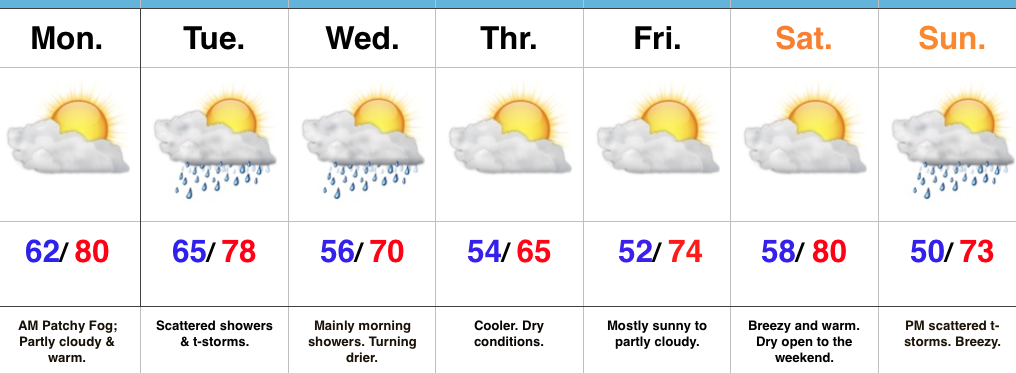
Active Times This Week…With the exception of patchy morning fog, the work week will get off to an uneventful start.  Unseasonably warm conditions will continue with sunshine.

A storm system will move out of the Mississippi Valley and into the Ohio Valley Tuesday into Wednesday.  This will help spread an initial round of showers and thunderstorms across central Indiana Tuesday morning, followed by more widespread showers and embedded thunder Tuesday evening into the predawn hours Wednesday.  Drier and cooler air will return Wednesday afternoon and Thursday is shaping up to be the coolest day of the week (very close to our average high of 66° for the date).

The cool air won’t last long as a southerly air flow returns in advance of our next storm system.  Saturday will be dry and breezy before clouds increase Sunday and scattered thunderstorms arrive Sunday afternoon and evening.  A more significant shot of cool air will invade early next week behind the frontal passage.

Upcoming 7-Day Precipitation Forecast:

  • Snowfall: 0.00″
  • Rainfall: 0.50″ – 1.00″

Warm Saturday; Storms Rumble In Late…

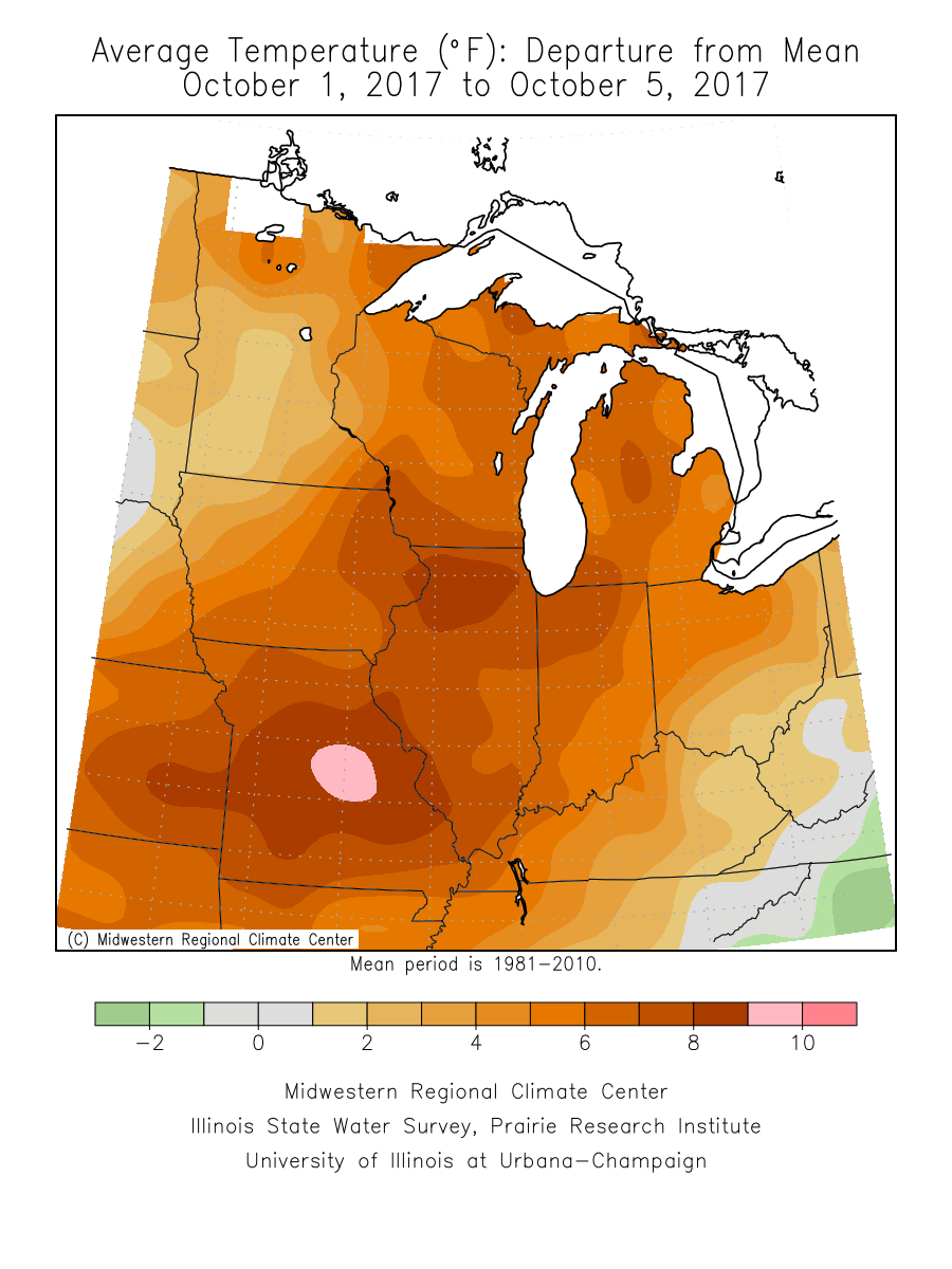
October has gotten off to a warm start (+ 8.4° at IND, to be exact) and that will continue this weekend as high temperatures top out between 80° – 85° Saturday.

October has gotten off to a warm start across the Mid West.

In addition to Saturday’s warmth, southwest winds will gust over 35 MPH at times- especially during the afternoon hours.

Most of Saturday will remain rain free, but we’ll need to keep an eye towards the western horizon Saturday afternoon as a frontal boundary helps kick up a line of thunderstorms.

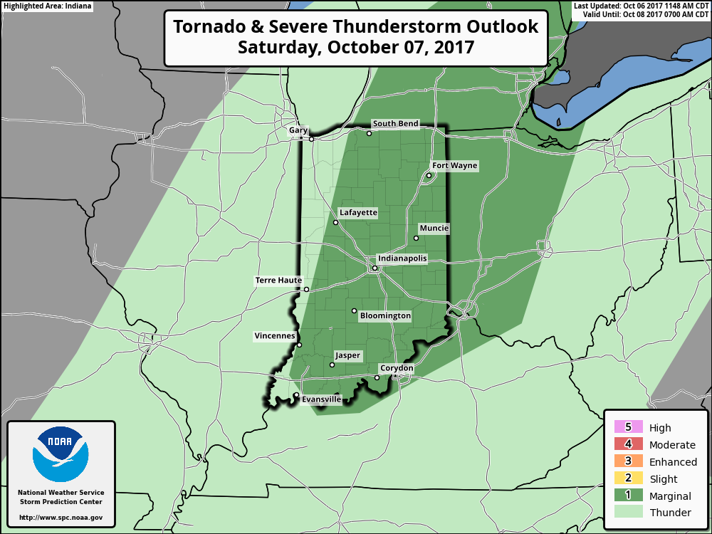
The Storm Prediction Center (SPC) includes a large portion of Indiana under a marginal risk of severe weather Saturday.  While widespread severe weather isn’t anticipated, a couple of embedded gusty storms are a good bet Saturday afternoon and evening.

The biggest concern with stronger storms is gusty straight line winds.  While the line of storms should be relatively “skinny,” don’t be surprised if one or two of the storms requires a warning.  Here’s an idea of what the radar may look like around 9p Saturday.
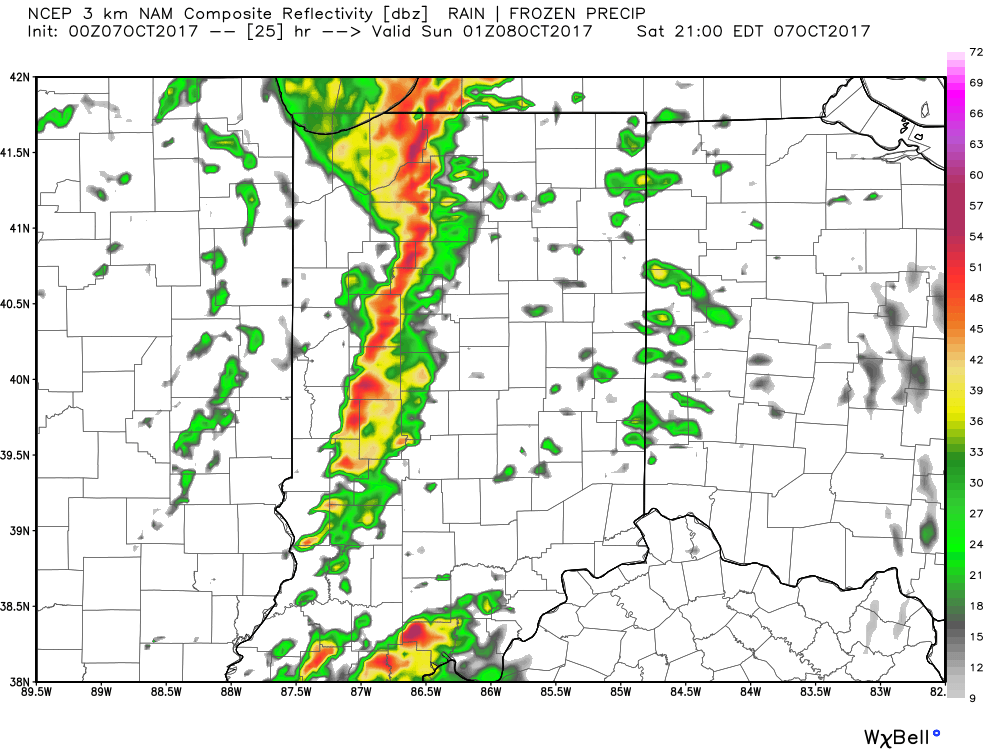
We’ll turn less humid and slightly cooler for the second half of the weekend!
More Rain For Some; Watching Nate…

Highlights:

  • Wet close to the work week for some
  • Saturday storms
  • Watching Nate

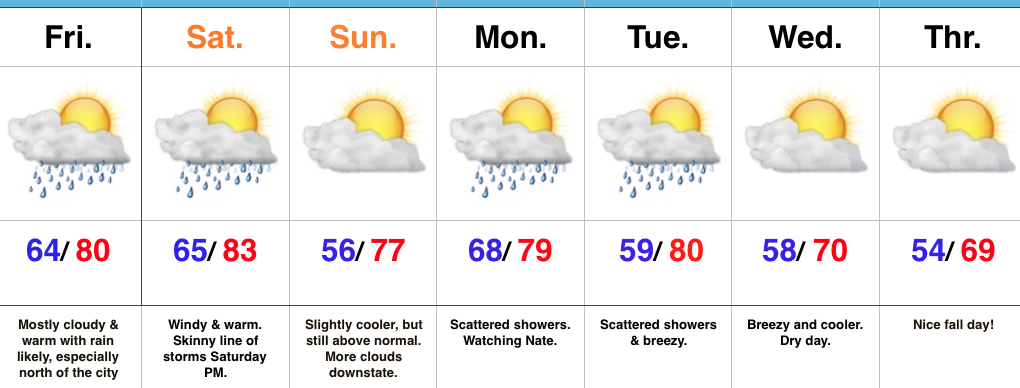
Unsettled Close To The Work Week…Thursday’s weather was just what the doctor ordered!  Officially, here at IndyWx HQ, we recorded 0.73″.  Many neighborhoods throughout central IN accumulated more than 1″ of much needed rainfall!  Thankfully, additional rain chances are present as we wrap up the work week.  Most widespread showers and embedded thunder will impact the northern half of the state Friday, especially the northern third of the state.

As we flip the page over to the weekend, mostly dry conditions can be expected, with the exception of a skinny line of thunderstorms that will blow through the state Saturday evening.  These will come and go rather quickly and we’ll get into a slightly cooler and drier regime to wrap up the weekend.

Attention this weekend will be what comes of Nate.  Overall, ideas haven’t changed over the past 24 hours, including an eventual late weekend landfall along the north-central Gulf Coast.  That said, precise all-important details concerning overall strength are still debatable.  Interests along the north-central Gulf Coast should monitor updates closely.  Here on the home front, we note subtle differences between the GFS and European in regards to inland impacts.  For now, we’ll go with a blend between the two, thinking most of the more significant, steady rains remain southeast of central Indiana.

Eventually a cold front will sweep through the state Tuesday night.  This will result in a NW wind shift and cooler air spilling in here later next week.

Upcoming 7-Day Precipitation Forecast:

  • Snowfall: 0.00″
  • Rainfall: 0.25″ – 0.75″

Monday Evening Rambles: Looking Towards October….

Irma: Irma’s remnants will begin to impact the state Tuesday. We noticed an increasing mid and high level cloud deck today and moisture will spread north to encompass southern Indiana…

You must be logged in to view this content. Click Here to become a member of IndyWX.com for full access.  Already a member of IndyWx.com All-Access?  Log-in here.