Category: Windy
 Highlights:
- Rainy weather today
- Much cooler conditions coming
- Prolonged stretch of strong winds
The region will be under a squeeze play of sorts today as tropical moisture continues to lift north from the Gulf Coast and a cold front approaches from the northwest. The end result will be for an expanding shield of rain to encompass a large portion of central IN as the day progresses. Heaviest rainfall is still expected downstate, but there will also be some localized heavier totals across central IN, as well. This, of course, is much needed.
The cold front will pass tonight and shut off any threat of rain. The big story will become the much cooler air mass settling into the region for the foreseeable future. Additionally, factor in the goings on along the eastern seaboard with an area of high pressure building in from the north and very windy conditions can be expected as we move through late week into the weekend. Strong and gusty northeast winds will be very persistent, with gusts up to 30 MPH at times.
We’ll continue to keep close tabs along the happenings along the eastern seaboard late in the period. As of now we think high pressure should keep us dry and cool, but stay tuned.
Upcoming 7-Day Rainfall Forecast: 0.50″-1″
Permanent link to this article: https://indywx.com/rain-today-windy-and-much-cooler-times-ahead/
 Highlights:
- Dry day before showers arrive tonight
- MUCH cooler weekend with showers around
- Dry and pleasant early-mid next week
The first of two cold fronts pushed through the region last night and helped usher in late day clearing that set up a beautiful sunset across central IN. The heat of September’s open is long gone and in it’s wake we can expect gorgeous weather today, with some sunshine before clouds increase later today.
A secondary cold front will sweep in to close the work week and this front will be responsible for delivering gusty showers Friday, followed by an airmass that’s more October-like than September over the weekend. It’ll be a perfect weekend for football, chili, bonfires, and all things pumpkin! 
Dry conditions return next week with moderating temperatures.
Upcoming 7-Day Rainfall Forecast: 0.50″
@Cryptics caught an amazing sunset last night, after what was a rather rainy, gloomy day.

Permanent link to this article: https://indywx.com/october-like-weekend/
-
Filed under Flooding, Forecast Discussion, Forecast Models, Heavy Rain, Long Range Discussion, Rain, Summer, T-storms, Unseasonably Cool Weather, Windy
-
June 27, 2015
Flooding is an issue across many central IN communities this morning. Particularly hard hit is the Muncie community. Zionsville’s Eagle Creek is also above flood stage this morning. Thankfully, breezy…
You must be logged in to view this content. Click Here to become a member of IndyWX.com for full access. Already a member of IndyWx.com All-Access? Log-in here.
Permanent link to this article: https://indywx.com/breezy-and-much-cooler-today-beautiful-sunday-on-tap/
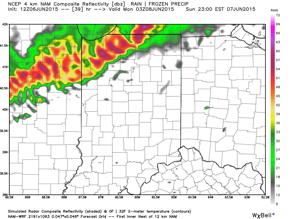
A cold front will slice into a hot and humid air mass Sunday evening. The daytime hours Sunday are expected to provide plenty of sunshine to go along with that hot and increasingly humid air mass (courtesy of strong southwest winds), but things will turn stormy Sunday night. We’re growing close enough now to begin to bracket the most likely time for potentially strong to severe thunderstorms and focusing in on the hours between 10p and 2a. Damaging straight line winds are of greatest concern, but large hail and a quick spin-up tornado can’t be totally ruled out. It’ll be important to set those weather radios before going to bed tomorrow night, or have a means of getting the latest watches and warnings.
Forecast radar 11p Sunday
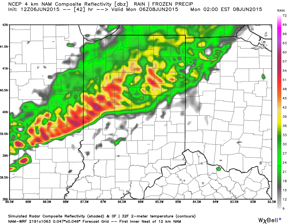
 Forecast radar 2a Monday
 Forecast radar 8a Monday
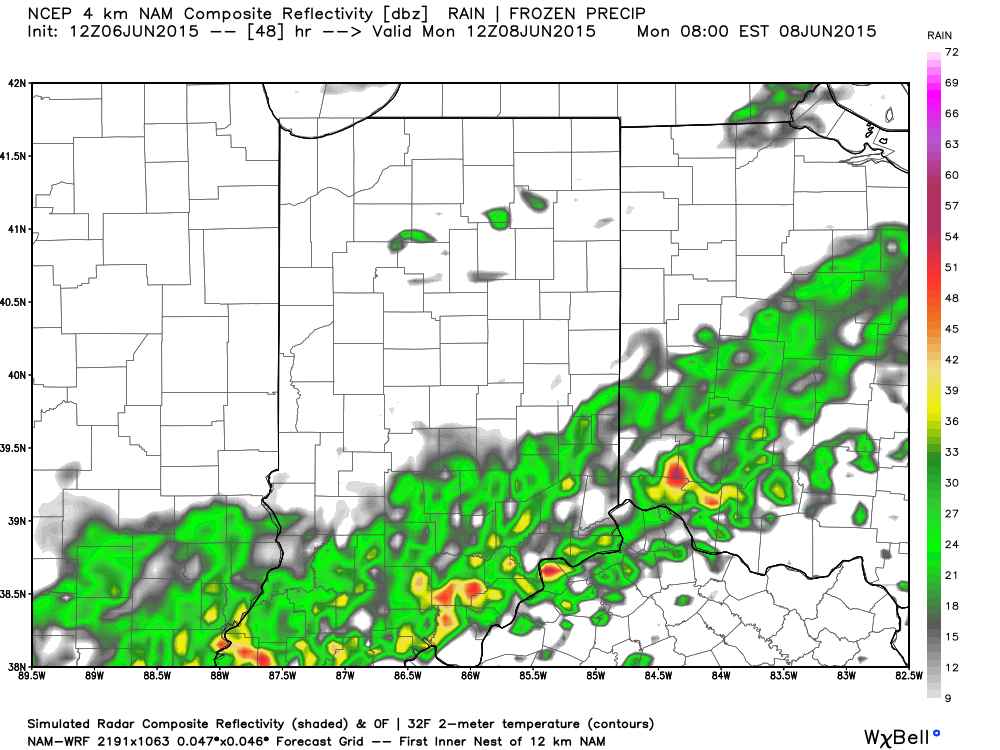 The line of storms will weaken in rather dramatic fashion as they continue to push south into the lower Ohio Valley and Tennessee Valley Monday morning.
Stay tuned.
Permanent link to this article: https://indywx.com/timing-sunday-severe-potential/
 Highlights:
- Frosty start Thursday and Friday for some
- Wet, chilly, and raw Saturday
- Brighter 2nd half of the weekend
- Watching next week
 Tonight’s water vapor loop, courtesy of WeatherTap.com, is showing drier air making it’s way into our region. This will set the stage for plentiful sunshine Thursday and Friday (well deserved, I might add :-)). Winds will also begin to diminish this evening. The combination of winds going calm and clearing skies will promote the chance of a frost and freeze across central IN tonight (and likely again tomorrow night) as reinforcing chilly air pours into the region. Those with ag. interests be sure to take note.
Attention then turns to the weekend and we’ll label it as “half-n-half” for now. A wet, chilly, and raw Saturday should give way to increasing sunshine Sunday. Early to mid next week will provide a new set of challenges and we’re leaning towards the wetter solutions yet again. Keep in mind the drier forecast model sets (GFS in particular) had to come around and play catch up to those leading the way Saturday (EC and GEM). Expect changes and stay tuned.
 Forecast lows tonight, thanks to Weatherbell.com, are suggested to fall into the lower to middle 30s. Should the wind go calm then expect a few readings around 30 degrees. We’ll likely dip near these readings again Friday morning.
 After a dry close to the work week, moisture increases late Friday night into Saturday morning. Expect a wet Saturday with early rainfall numbers projected in the 0.50″ to 1″ range.


Permanent link to this article: https://indywx.com/frosty-weather-turns-wet-saturday/
