 Highlights:
- Sunshine works in today
- Weak weather maker Tuesday
- Chilly pattern turns downright cold to close the week
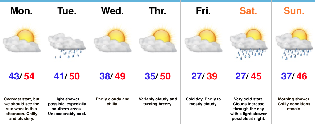
Have The Jackets And Coats Handy…After a rough Sunday filled with flooding and severe weather, we’re opening the work week on a much quieter, albeit much colder, note! An overcast start to the day should gradually give way to increasing afternoon sunshine. We’ve already experienced our high for the day (at midnight) and temperatures for most will remain in the 40s today, coupled with a brisk north breeze.
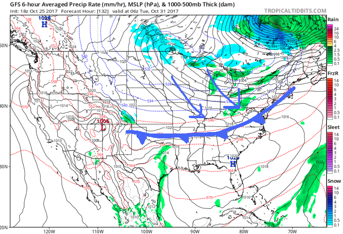
Our next weather maker will pass to our south Tuesday and this could spread a light shower as far north as central Indiana early Tuesday morning. Better rain chances will remain across southern portions of the state, but even here rainfall amounts will remain light.
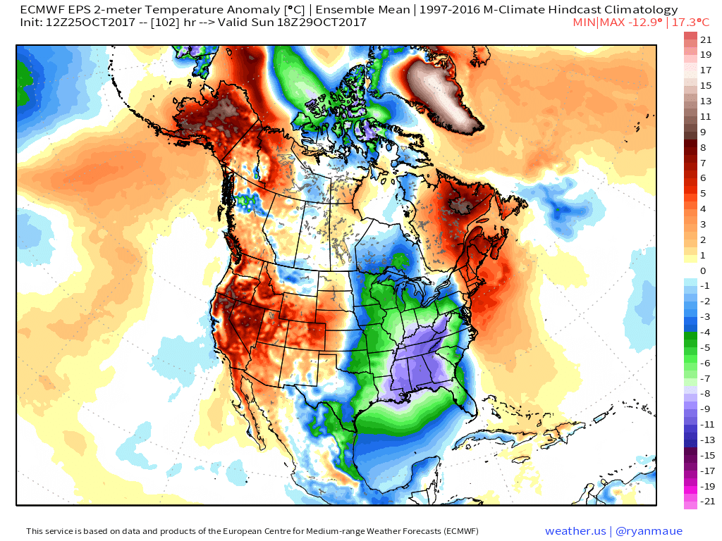
Dry, unseasonably chilly conditions will prevail for midweek before a stronger blast of chill pushes in to close the week. This air mass will be of arctic origin and deliver the coldest temperatures so far this autumn. A hard freeze is expected Friday and Saturday mornings. Moisture will return over the weekend with light rain possible Saturday night into Sunday.
Upcoming 7-Day Precipitation Forecast:
- Snowfall: 0.00″
- Rainfall: 0.10″ – 0.30″
 Highlights:
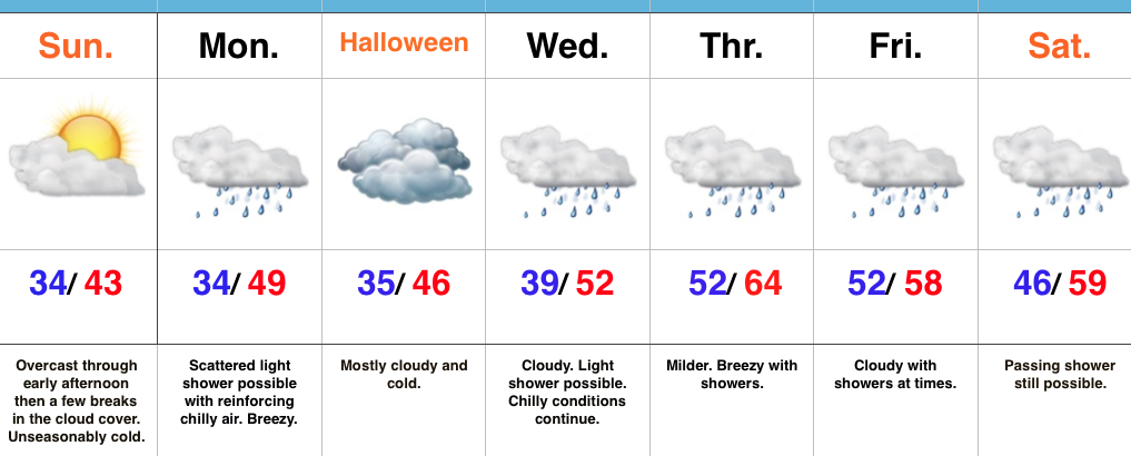 Highlights:
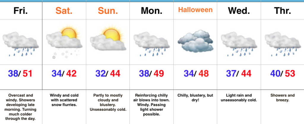 Highlights:
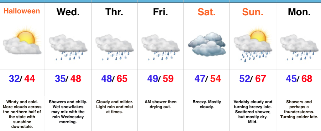
 II. Gusty Thursday: After a cold, calm start to our Thursday, southerly winds will become gusty late in the afternoon. This is a result of an approaching cold front that will impact the region Friday.
 III. Unseasonably Cold Weekend: A cold front will pass Friday afternoon and a band of showers will accompany the frontal passage. Winds will shift to the northwest late in the day and drive in a sharply colder close to the work week. Air will grow cold enough to potentially support snow to mix in with the rain as precipitation comes to an end. Additionally, upper level energy and the colder air mass this weekend (the air will have a bite to it) could support mixed rain and snow showers Sunday. – Novelty stuff only, but those first flakes are always special to see. Nonetheless, temperatures will run well below normal. In fact, highs will be closer to our average low temperature this weekend.
 IV: Reinforcing Halloween Chill: We still stand firm on the idea of warm costumes being required this Halloween as chilly reinforcements blow into town Monday night. This will result in Halloween featuring a high in the mid to upper 40s with lows Tuesday night/ Wednesday morning dipping to around freezing (upper 20s in outlying areas away from the metro). Most of Trick-or-treat hours should feature temperatures in the upper 30s and lower 40s.