You must be logged in to view this content. Click Here to become a member of IndyWX.com for full access. Already a member of IndyWx.com All-Access? Log-in here.
Category: Windy
Permanent link to this article: https://indywx.com/video-a-much-colder-pattern-is-here-scattered-snow-showers-sunday/
Oct 23
Wet Start To The Work Week; Taste Of Winter This Weekend…
 Highlights:
- Wet, gloomy open to the work week
- Dry midweek
- Much colder this weekend
- First flakes of the season
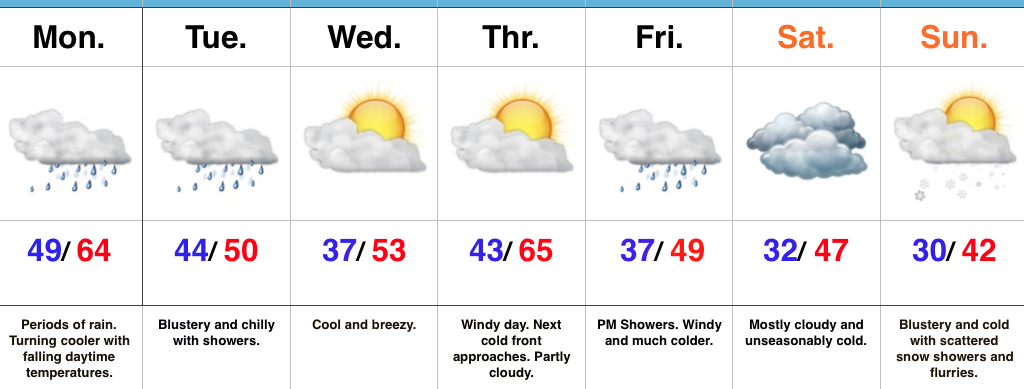
Rain Gear Required…Low pressure will track through the Ohio Valley and into the Great Lakes between now and Tuesday morning. This will result in a wet day, including periods of moderate to heavy rain. Once the cold front slips through central Indiana, we’ll notice slowly falling temperatures this afternoon. We’ll throw in a gusty NW breeze tonight into Tuesday with showers and chilly conditions remaining in place.
Drier air will work in for the midweek stretch. After patchy frost Wednesday, a cool, crisp day is on tap with increasing sunshine. Thursday will feature strong and gusty southwest winds (gusts over 40 MPH), but dry conditions ahead of an approaching cold front. That cold front will blow through here Friday with a band of showers and sharply colder air to end the work week.
The air will turn cold enough to end the growing season this weekend across central Indiana. Additionally, a combination of upper level energy and reinforcing cold air Sunday will interact with the unseasonably warm lake waters to help generate scattered snow showers and flurries. When we compare this upcoming Sunday to yesterday, it’ll add insult to injury as temperatures will be more than 30° colder…
The 2017-2018 IndyWx.com Winter Outlook is now available.
Upcoming 7-Day Precipitation Forecast:
- Snowfall: Trace
- Rainfall: 1.00″ – 2.00″
Permanent link to this article: https://indywx.com/wet-start-to-the-work-week-taste-of-winter-this-weekend/
Oct 22
VIDEO: Heavy Rain Gives Way To Colder Air…
You must be logged in to view this content. Click Here to become a member of IndyWX.com for full access. Already a member of IndyWx.com All-Access? Log-in here.
Permanent link to this article: https://indywx.com/video-heavy-rain-gives-way-to-colder-air/
Oct 22
So Long Warm Autumn Weather; Colder Changes Ahead This Week…
 Highlights:
- Bye-bye unseasonably warm weather
- Wet start to the work week
- Colder times loom
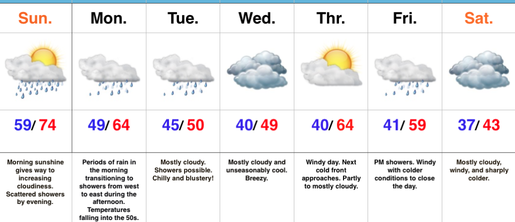
Early Sunday Sun; Rain Increases In Coverage Tonight…The morning is off to a pleasant start, including unseasonably mild conditions and a SW breeze. Clouds will thicken up this evening and a scattered shower will be possible. Rain will increase in coverage and intensity tonight into Monday as an area of low pressure tracks into the Ohio Valley and eastern Great Lakes by Tuesday morning. Steadiest rain will impact central Indiana Monday morning before diminishing to showers Monday afternoon and evening. Temperatures will fall into the 50s Monday morning into the afternoon.
A bigger “jab” of chilly air will plunge into the region for midweek. Considerable cloudiness will accompany the unseasonably chilly conditions, along with a gusty northwest breeze.
As we look ahead towards next weekend, another in a series of cold fronts (get used to that) will eye a Friday evening approach. Showers will be possible as this front blows through the region. Sharply colder air looms next weekend. Frost and freeze conditions will likely develop early next week, along with the first flakes of the season…
The 2017-2018 IndyWx.com Winter Outlook is now available!
Upcoming 7-Day Precipitation Forecast:
- Snowfall: 0.00″
- Rainfall: 1.25″ – 1.75″
Permanent link to this article: https://indywx.com/so-long-warm-autumn-weather-colder-changes-ahead-this-week/
Oct 19
Calm And Sunny Now; Big Changes Ahead…
 Highlights:
- Sunny, pleasant weather continues for now
- Weekend cold front
- Much colder next week
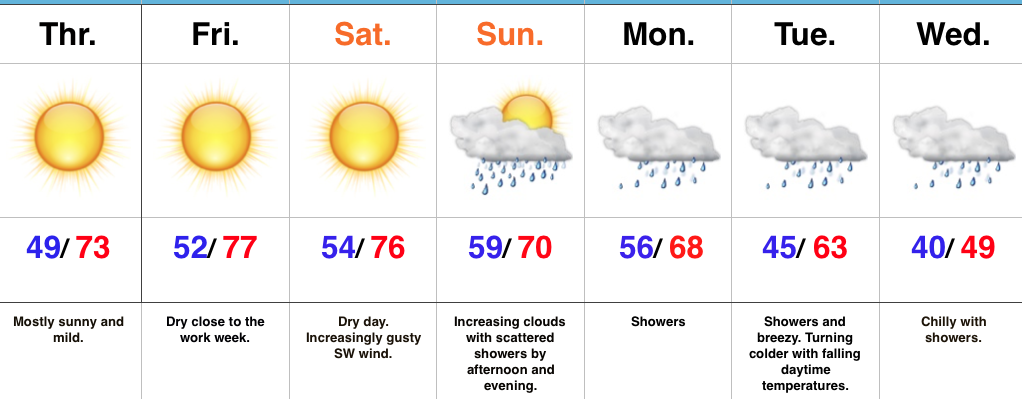
Easy, “Breezy” Forecast Into The Weekend; Questions Loom Thereafter…There’s really no need to waste a bunch of pixels on the short-term forecast. High pressure will remain in control and supply plentiful sunshine into the first half of the weekend. Mild temperatures will continue and we’ll add a gusty southwest breeze into the mix Saturday.
A cold front will approach the state Sunday and this will lead to increasing cloudiness along with scattered showers by the afternoon into the evening. Thereafter, questions loom around important details that will potentially increase what will, at the very least, be “nuisance” level showers and mist into mid week towards an all-out rain storm, including widespread 2″+ totals. Stay tuned as we continue to fine tune things. We’ll have an update later today.
One thing that hasn’t changed and doesn’t require us to ask any questions is the coming chill. Temperatures will fall through the day Tuesday and highs may not make it out of the 40s Wednesday…
It’s that time of year again! The annual IndyWx.com Winter Outlook will arrive on the site this weekend.
Upcoming 7-Day Precipitation Forecast:
- Snowfall: 0.00″
- Rainfall: 1.00″ – 1.50″
Permanent link to this article: https://indywx.com/calm-and-sunny-now-big-changes-ahead/
