Category: Windy

Wet To White (At Times) Through Early Week…

A quick note before we dive into the upcoming forecast pattern.  Instead of issuing 7-day posts within the blog format, the most updated IndyWx.com 7-day forecast will now be featured at the top left of the site.  We’re continuously trying to provide you the information and content you need in a quick and concise manner- eliminating having to “scroll and search” (unless you’re bored, of course ;-))!

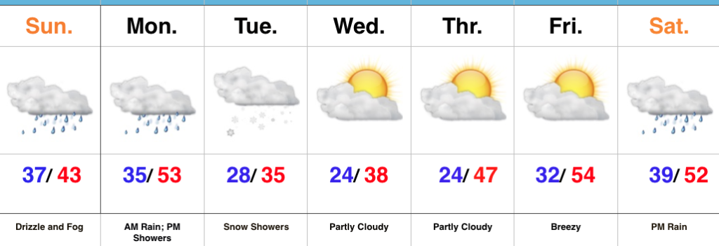
Areas of fog and drizzle will continue this evening before a stronger southwesterly air flow pushes the low clouds and fog north during the overnight.  As a cold front draws closer, steadier rains and perhaps even a clap of thunder (especially down state) will arrive Monday morning.  Temperatures will remain nearly steady or even rise overnight into the lower 50s.

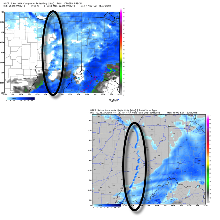
The frontal passage, itself, will take place Monday evening and may feature a couple of gusty showers, especially across western and central portions of the state.

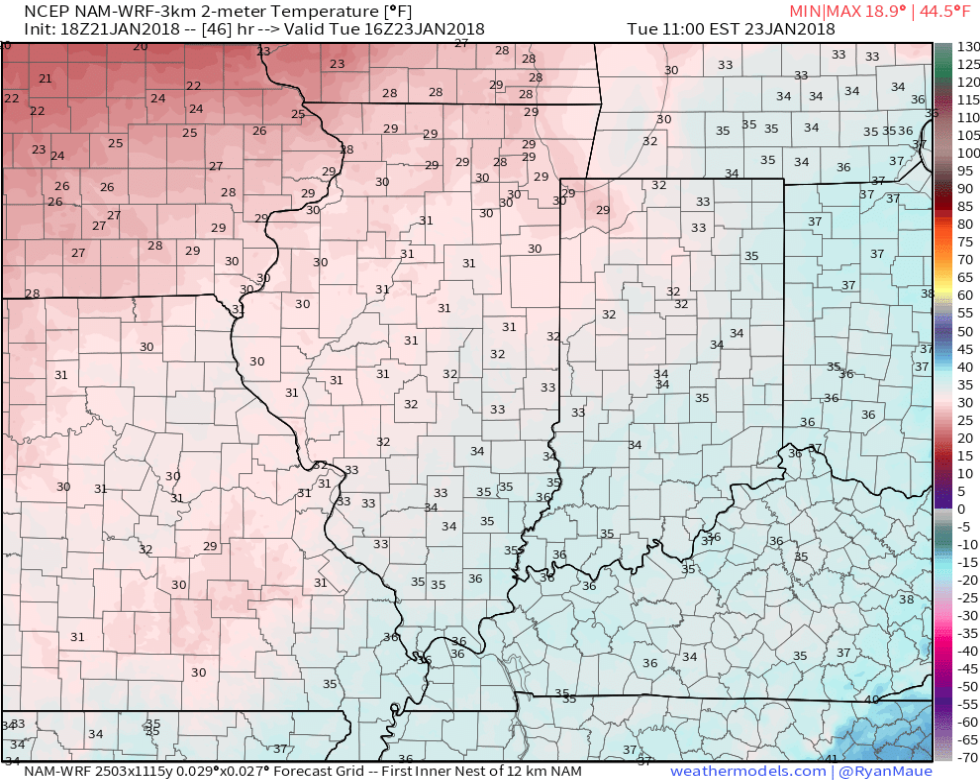
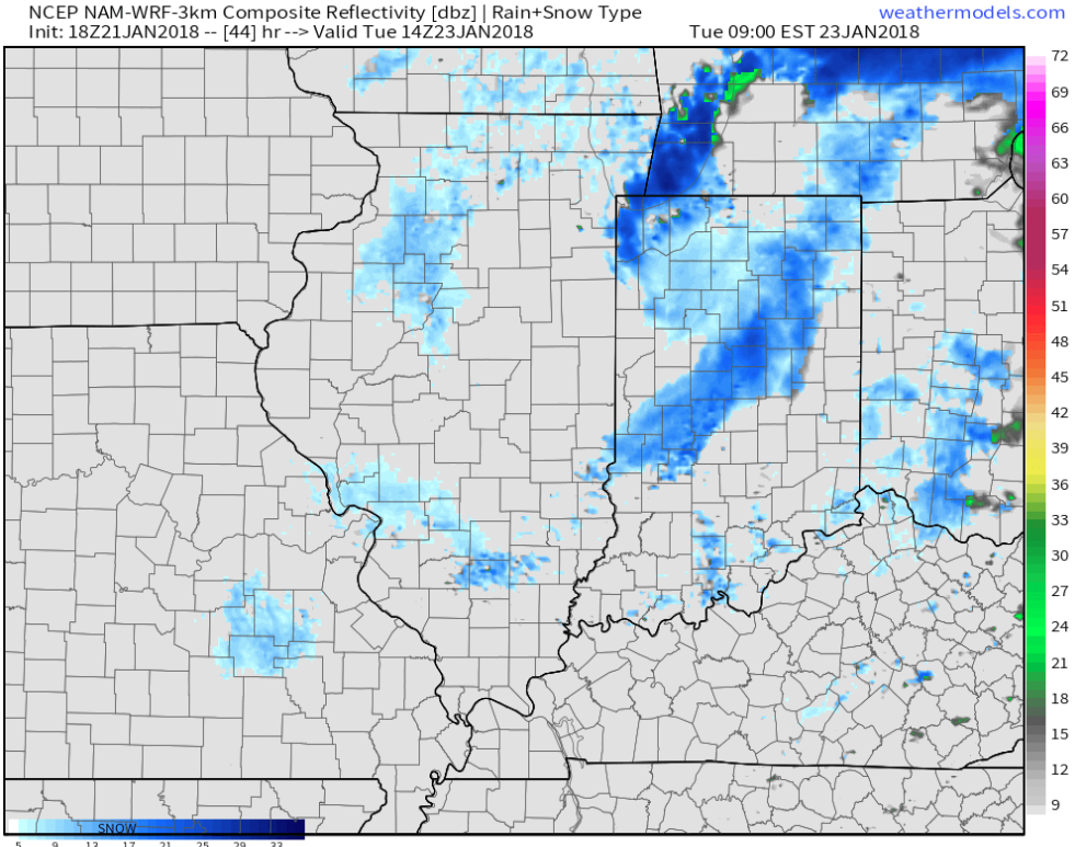
Temperatures will grow colder Monday night into Tuesday morning and precipitation will end as snow showers Tuesday.

High pressure will build in through midweek and provide dry conditions with increasing sunshine.  The midweek stretch will begin seasonable before warming ahead of our next storm system.

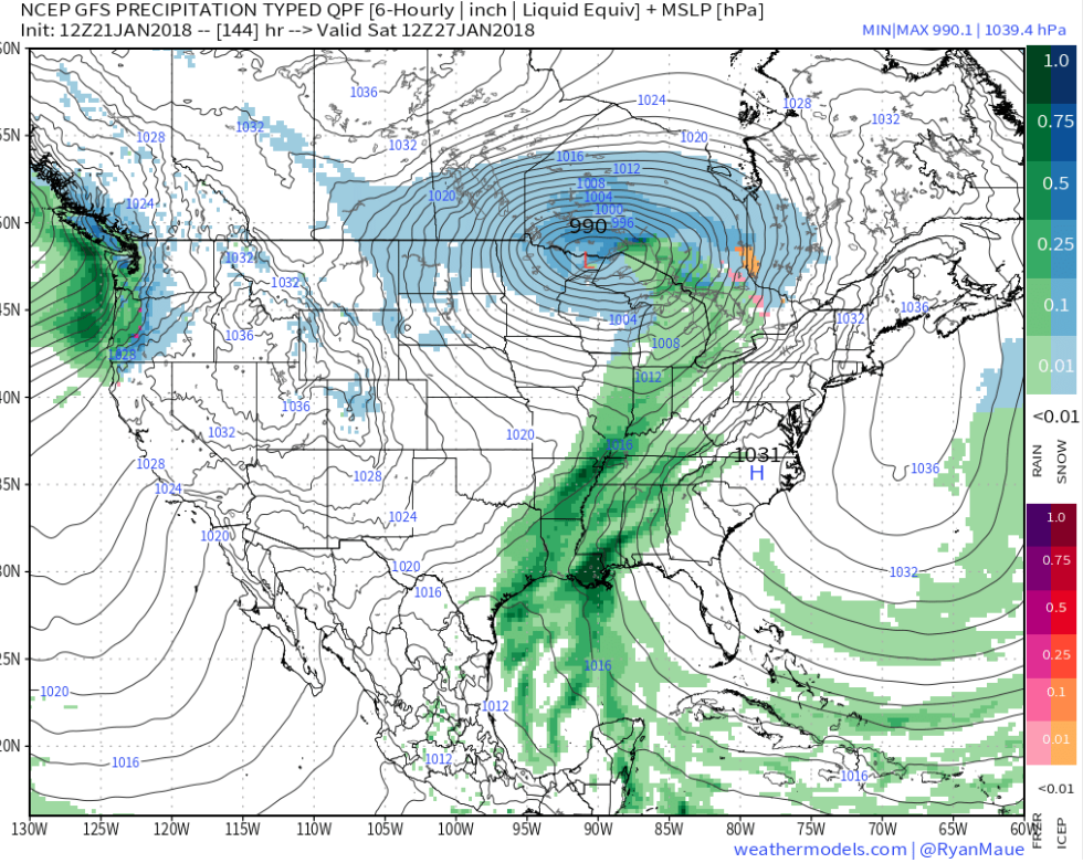
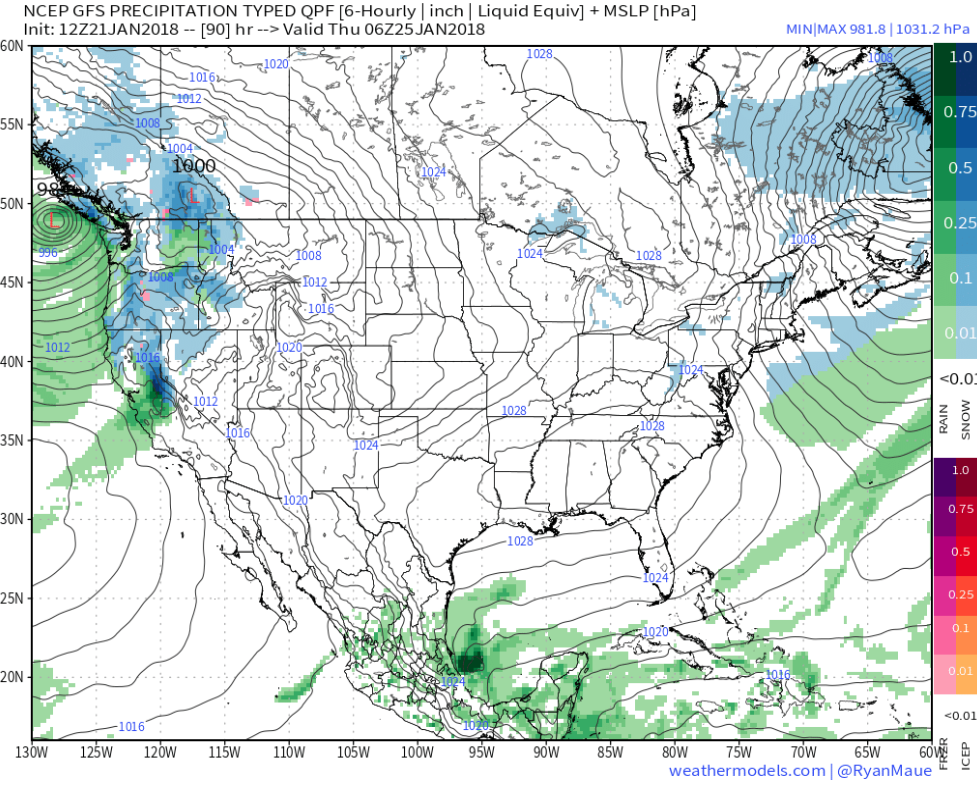
That next storm system will deliver rain as early as Friday evening into Saturday.  We’ll note an increasingly gusty southwesterly breeze as we wrap up the work week, along with increasing cloudiness.

Permanent link to this article: https://indywx.com/wet-to-white-at-times-through-early-week/

Milder, But Active…

Highlights:

  • Gloomy close to the weekend
  • Rain-to-snow early week
  • Significant storm next weekend

Drizzle And Fog Develops…Our Saturday opened with plentiful sunshine and milder conditions.  Unfortunately, the low cloud deck invaded through the afternoon hours and will take up residence through Sunday.  Fog and drizzle will develop tonight and continue through most of Sunday.

Steadier rains will arrive on the scene late Sunday night into Monday morning ahead of an approaching cold front.  That cold front will sweep through the state Monday afternoon with additional showers and a dramatic wind shift.  Colder air will then press into the region and as wrap around moisture swings through the state, snow showers will develop Tuesday.

As mentioned in previous posts, we’re in a transient and very active regime.  Just as soon as the colder air arrives for midweek, we’ll shift our air flow around to the southwest and usher in milder times to close the week.  A significant storm system is brewing next weekend.  We’ll forecast increasing cloudiness Saturday with rain arriving by afternoon.  We’ll have to keep tabs on next Sunday for the possibility of wintry conditions returning…

Upcoming 7-Day Precipitation Forecast:

  • Snowfall: Dusting
  • Rainfall: 0.50″ to 1.00″

Permanent link to this article: https://indywx.com/milder-but-active/

“Less Harsh;” Weekend Rain…

Highlights:

  • Turning “less cold”
  • Weekend rain
  • Chilly early next week

Sunny And Not As Cold…The arctic high that delivered the bitterly cold conditions over the past few days is scooting off to the southeast.  This will put the state under a milder (all relative :-)) southwesterly flow and temperatures will become “less harsh” as we wrap up the work week!

An approaching storm system will lead to increasing clouds during the afternoon and evening Saturday and drizzle will follow Sunday morning.  As the cold front draws closer, steadier rains will arrive Sunday night into Monday.  Colder times will sweep in behind the front and allow left over precipitation to end as snow showers Monday (not a big deal).

Tuesday and Wednesday will feature dry and chilly conditions.

Upcoming 7-Day Precipitation Forecast:

  • Snowfall:  Dusting
  • Rainfall:  0.25″ to 0.75″

Permanent link to this article: https://indywx.com/less-harsh-weekend-rain/

Monday Morning Notes…

Bursts of moderate to heavy snow will work across the metro during the next couple hours. This will lead to significant drops in visibility and serve to mess up roadways even more than they currently are. If you don’t have to travel through the morning hours we recommend staying home and allowing road crews time to get things cleaned up.

Most of the steady accumulating snow will be over with by late morning and we’ll just be left with scattered snow showers through the afternoon hours. Perhaps the bigger story by then will be significant blowing and drifting snow as gusty westerly winds help usher in colder air. If your travels include country roads, or north-south oriented highways, plan on considerable blowing and drifting snow this afternoon and evening.

We have no changes to our going snowfall forecast with this system.

Finally, as the arctic front sweeps through the state this afternoon, it’ll likely kick up some intense, blinding snow bursts.  While these won’t last long, they’ll blast through during the evening rush and will serve to dramatically lower visibility.  We note high resolution models are picking up on these snow bursts on forecast radar products.

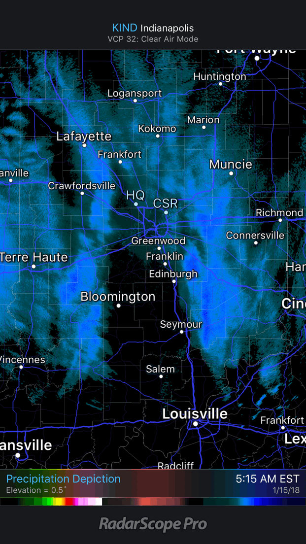
We’re left tonight with bitterly cold conditions that will continue to grip the region through midweek. Most of us Tuesday morning will be below zero. A moderating trend will develop by late week, continuing through the weekend!
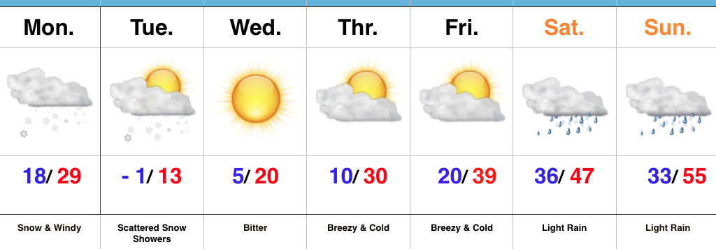
Permanent link to this article: https://indywx.com/monday-morning-notes/

Gas Up The Plows; Arctic Air Returns…

Highlights:

  • Heavy snow Monday morning
  • Bitter air returns
  • Milder, wet weekend

Snowy Open To The Week…A vigorous clipper system and associated arctic cold front will drop southeast and spread a swath of snow across the region tonight into Monday.  We expect light snow to encompass most of central Indiana later this evening (between 7p and 10p west to east) before increasing in overall intensity during the overnight.  Periods of moderate to heavy snow can be expected during the mid-morning hours Monday, including impressive snowfall rates at times.  Allow plenty of extra time to reach your destination Monday.  Steady snow will give way to scattered snow showers during the afternoon, continuing into Tuesday as fresh arctic air pours into the region.  By the time all is said and done, most of the region can expect a fresh 2″ to 4″, including some locally heavier totals.  The other item on the agenda will be blowing and drifting snow that we’ll have to deal with Monday afternoon through the night and into Tuesday.

Arctic high pressure will settle overhead Tuesday night through the midweek stretch, allowing sunshine to return, but we’ll remain well below average (average temperatures this time of year include highs in the mid-30s and lows around 20).

A moderating trend takes place late week, but the “less cold” air will come with gusty southwesterly winds and increasing clouds Friday.  Those clouds will give way to periods of rain along with milder conditions over the weekend as an area of low pressure tracks into the Great Lakes.

Upcoming 7-Day Precipitation Forecast:

  • Snowfall: 2″ to 4″ (locally heavier totals)
  • Rainfall: 0.25″ to 0.75″

Permanent link to this article: https://indywx.com/gas-up-the-plows-arctic-air-returns/