You must be logged in to view this content. Click Here to become a member of IndyWX.com for full access. Already a member of IndyWx.com All-Access? Log-in here.
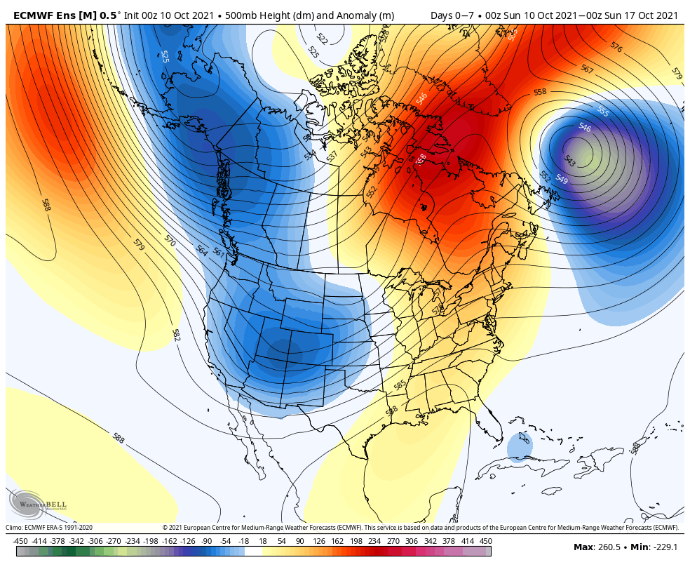
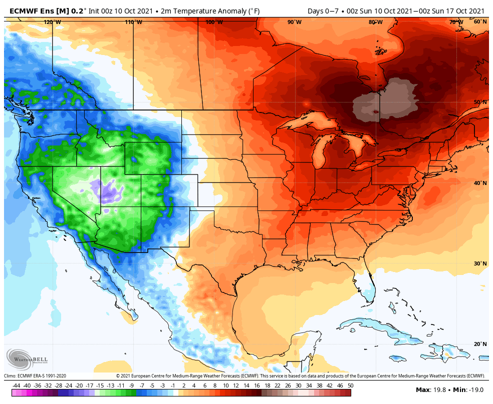
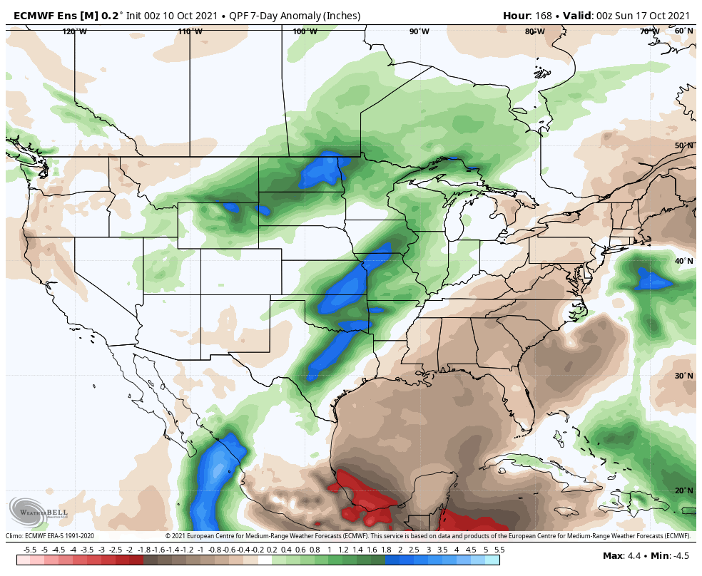
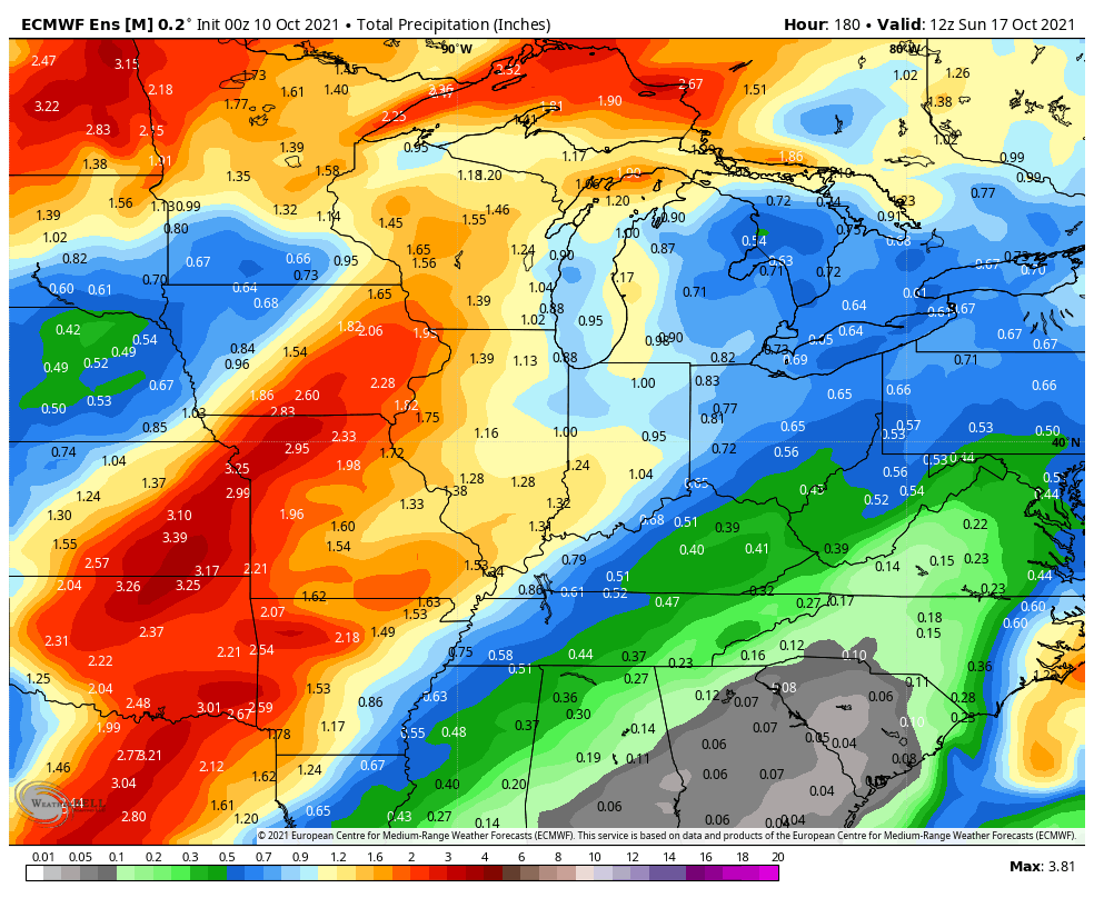
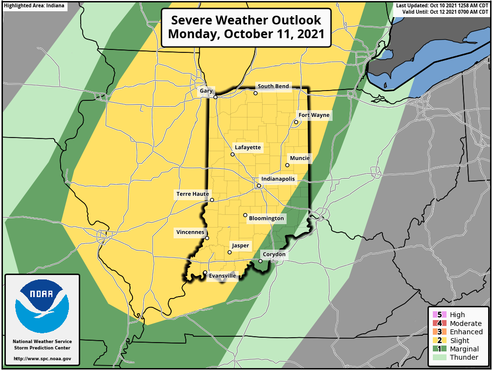
The predominant pattern in the week ahead will feature an eastern ridge and western trough. Temperatures will run well above normal across the East while an early taste of winter will reside across the West. Rainfall will run well above normal this week from the southern Plains into the western Great Lakes along with the northern Plains. We think most central Indiana rain gauges accumulate between 0.75” and 1.25” in the 7-day period.We continue to track the potential of strong to severe storms Monday afternoon and evening.
Forecast Period: 10.10.21 through 10.17.21
While the bulk of the forecast period will run well above normal, this will be a much more active 7-day period than we’ve seen of late. The first storm system will approach Monday afternoon. After a warm, breezy, and mostly dry day, a line of storms will move through from west to east during the afternoon and evening. Strong damaging straight line winds appear to be the greatest threat but there will also be the potential of an isolated tornado. We bracket the hours from 2p to 10p for this line of storms to impact the state. Another storm system will move through the area late in the work week with widespread rain and a shot of much cooler, fall-like air as we head into next weekend. Dry conditions should return just in time for the weekend.
A trough will settle into the eastern portion of the country as we move into the 2nd half of the week. Meanwhile, ridging will expand across the West.
Warmer than normal conditions will dominate the period across the West and northern tier while cooler than average temperatures settle into the Ohio Valley and Southeast.
Well above normal rainfall is expected in the Ohio Valley into the eastern Great Lakes.
We forecast between 2″ and 3″ of rain to fall across central Indiana in the upcoming 7-day period- heaviest totals are expiated across far eastern parts of the state.
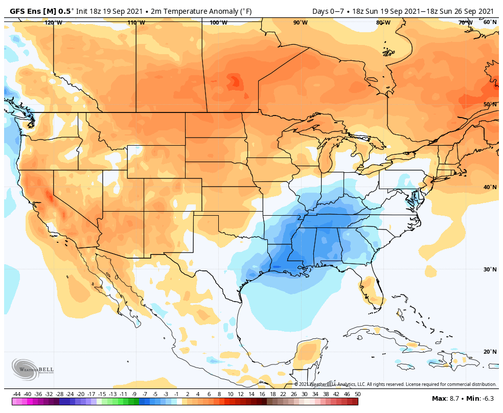
Forecast Period: 09.19.21 through 09.26.21
A much more active weather pattern will take control of the region during the above mentioned forecast period. An area of low pressure will track north into the Ohio Valley during the overnight and Monday morning which will help lead to an expanding area of rain and embedded thunder to kick off the work week. Rain is expected to be most widespread across the southern half of the state early in the day before making progress north. As this is taking place, a cold front will take aim on the region from the west, and should push through the Hoosier state Tuesday with a line of showers and thunderstorms. While there could be a couple of stronger storms widespread severe weather isn’t expected. Perhaps what will be a bigger “headache” will have to do with the evolution of things as the front is moving east across Indiana. A wave of low pressure is expected to develop to our south Tuesday before lifting north…
As of Sunday evening, two of our more trusted forecast models (GFS and European) differ with respect to exactly where the developing surface low will track (GFS is more progressive while the European is slower). Regardless, MUCH cooler air will pour into the region through the middle of the week. Should the slower European solution (our lean at the moment) come to fruition, then we’re looking at a midweek rain out, combined with October-like daytime temperatures. Chili weather, anyone?! Stay tuned for future updates as we fine tune things for midweek. High pressure will return in time for the weekend, allowing sunshine and pleasant fall temperatures to claim headlines.
The upper air pattern this week will feature a trough across the Northeast and Great Lakes with an upper ridge anchored over the Four Corners.
Temperatures will run below average from the Ohio Valley into the MS Valley, with well above normal temperatures expected across the West.
Most of the country can expect below to well below average precipitation in the week ahead. The one exception? Northern New England.
We only forecast 0.10″ to 0.25″ of rain here in central Indiana during the 7-day period.
Forecast Period: 09.05.21 through 09.12.21
A very quiet weather pattern will settle into the region as we go through the upcoming week. The one exception to that is Tuesday night as a cold front quickly passes through the area. Moisture levels will return ever so slightly ahead of the boundary and may be enough to produce a couple of storms Tuesday evening (widely scattered coverage). The front will help to reinforce the dry airmass in place, along with provide cooler temperatures for mid and late week. As we look ahead beyond this week, indications are that things will moderate and turn a bit more active (though that’s admittedly not saying much, considering just how quiet things will be this week).
A persistent trough will remain in place across the northern Rockies while weak ridging takes up shop across the Great Lakes region.
Warmest anomalies through the forecast period can be expected across the Mid-Atlantic and central Plains, into the Southwest. The northern Rockies will remain cooler than normal. The cooler than normal conditions across the central Gulf Coast region is associated with the daytime highs being lower as Ida moves north early in the period.
The biggest focus through the middle of the week will have to do with the remnant moisture associated with Ida. Active times will return to the upper Midwest as well.
We forecast 7-day rainfall amounts to check-in between 1″ and 1.5″ for most of central Indiana.
Forecast Period: 08.28.21 through 09.04.21
The period will open with an active weather pattern. A cold front will slowly press south through early week. At the same time, Hurricane Ida is forecast to make landfall along the north-central Gulf Coast (likely along the LA coastline) Sunday afternoon, and as a major hurricane at that. The remnant moisture of Ida will lift north before curling east. Eventually, we believe the remnant moisture of Ida will get tangled up with the aforementioned cold front. While we’ll need to keep a close eye on data to see if any adjustments are needed early week, as of now, we believe the heavy rain threat will lie just south of our immediate area (more so along and south of the OH River). We’ll keep a close eye on things. Regardless, scattered to numerous showers and thunderstorms are expected as the cold front sinks south. By midweek, the region will be in a much drier (and somewhat cooler) northeasterly airflow. Dry conditions are expected to continue into the holiday weekend ahead with slowly moderating temperatures.