
You must be logged in to view this content. Click Here to become a member of IndyWX.com for full access. Already a member of IndyWx.com All-Access? Log-in here.
Category: Weather Rambles
Permanent link to this article: https://indywx.com/monday-morning-video-update-2/
Jul 08
Friday Morning Rambles…
1.) We’ve got another warm, humid day dialed up and as a cold front moves in this afternoon, scattered strong to severe storms are possible. We think east-central Indiana stands the greatest threat at experiencing a severe storm later this evening.
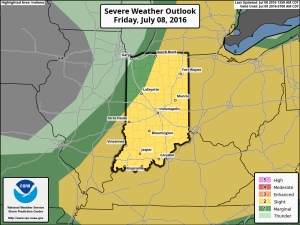
 2.) The aforementioned cold front will sweep through the state tonight and allow a much drier and cooler air mass to push in for the weekend. We’ll enjoy a downright pleasant feel this weekend, including lots of sunshine. Enjoy!
 3.) Dry weather should continue into early next week, but wet and stormy weather will return as early as Tuesday, continuing into the latter portions of the week.
 This is the start of what should be a rather wet period for mid and late month.
 4.) This is also a continued “transient” pattern through the end of the month, meaning we really don’t see any sort of sustained dry, hot weather in the foreseeable future…
Permanent link to this article: https://indywx.com/friday-morning-rambles-3/
Jul 05
Entering A Stormy Period…
We’re enjoying quiet times across Indiana this evening, but times are quickly changing to put us into a stormy position between Wednesday morning and wrapping up the work week.
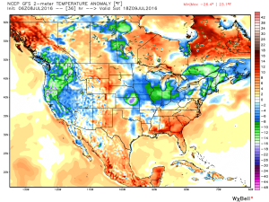
While the overall pattern is an easy one to label from a broad scale perspective as “stormy,” the precise details are incredibly difficult to pin point much more than 12-24 hours in advance. With that said, most of the state is very much in fair game for periods of storms (generally tracking in a NW to SE fashion) between now and the end of the work week. Eventually, drier air will set us up for a very pleasant weekend, including lots of sunshine and cooler temperatures. In fact, latest data still suggests we can expect to wake up to the 50s Sunday and/ or Monday morning(s).
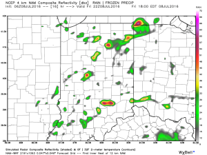
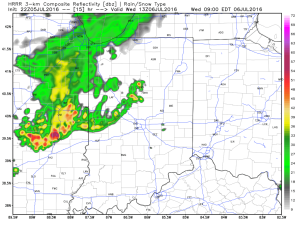
Before we enjoy the pleasant weekend weather, the first of a series of storm complexes will approach Wednesday morning. Mesoscale Convective Complexes (MCCs) can be a true pain for short-term modeling to handle, but the overall idea this evening is for the first of (2) complexes to impact parts of the region Wednesday morning.
This is an idea what the radar may look like around 9a. This would be the same complex that will deal quite the blow to portions of the eastern Plains and upper Mid West tonight (localized damaging straight line winds will be an issue to our NW). Thankfully, we expect weakening of this complex as it dives off to the SE, in our general direction.
 We’ll go through a quiet period during the afternoon hours before a second surge of storms takes aim on the region tomorrow night into Thursday morning (again, understanding we’ll have to “sure up” timing as we go).
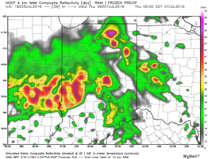 Additional storm complexes will follow Thursday into Friday before that drier air gets here. Some of these could be strong to severe.
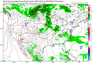
While rainfall amounts won’t be uniform, there’s the potential for some neighborhoods to get 2″-3″ of rain between now and week’s end (where storms train).
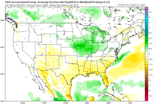
 Looking ahead, after a dry weekend and open to next week, indications point towards a return of wet and active times as we approach Day 10. Long range ensemble data backs up the wet, stormy look nicely, and there’s really no end in sight…
Permanent link to this article: https://indywx.com/entering-a-stormy-period/
Jun 13
Some Thoughts Into Late June…
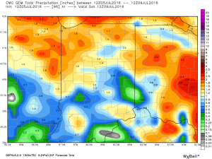
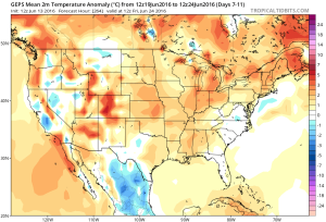
The first (12) days of June are in the books and we’re running drier and warmer than average, month-to-date. Officially, IND reports a temperature departure of 3 degrees above normal and a rainfall deficit approaching 1″.
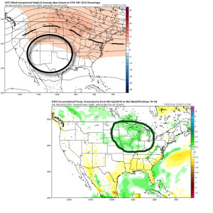
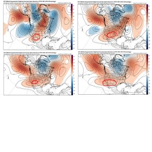
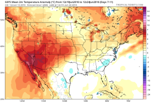
As we look ahead, the pattern is one that seems to favor the most sustained hot dome (mean ridge) position across the 4 Corners region and Southwest states. This morning’s European ensemble data shows this well:
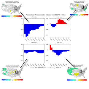
 The teleconnections aren’t much help in trying to generate longer term thoughts. They would favor more of a “normal” period temperature-wise, locally. (BTW, thanks to the fine folks at MAD US Weather and ESRL for the data below).
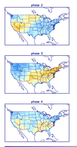
On another note, there are different times through the year when the respected positive and negative phases of the teleconnections below have more of an impact on our weather, particularly during the fall through spring months.
 Looking at some of the model data, the general consensus is for a warm look to go through the back half of the month, but we caution that we can’t simply “broad brush” the forecast through the EOM as warm and relatively quiet (a note on that in a moment).
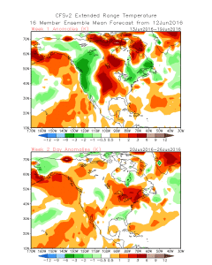
 As mentioned above, despite an overall warm look on the models there will likely be periods of cooler “jabs” and it sure looks like a rather transient pattern to us across the Mid West and Ohio Valley, featuring more of the sustained heat across the Southwest region. Transient patterns usually also yield for potential wetness and we note the GFS Ensembles trending in that direction to wrap up the month.
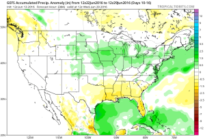 In the shorter term, there will also be localized heavy downpours, but it’s a continued case of “haves and have nots.” There won’t be any particular rhyme or reason to the specific placement of heavy, gully-washer type showers and storms mid week.
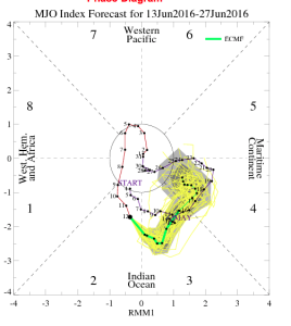
Finally, to close, perhaps the MJO shows the pattern best over the next couple weeks. Best word to describe the MJO’s idea? Transient. 🙂
Permanent link to this article: https://indywx.com/some-thoughts-into-late-june/
Jun 10
Friday Evening Video Update…
A hot and humid weekend is in store, but we’re eyeing increasingly wet and unsettled times by the middle of next week…
You must be logged in to view this content. Click Here to become a member of IndyWX.com for full access. Already a member of IndyWx.com All-Access? Log-in here.
Permanent link to this article: https://indywx.com/friday-evening-video-update-5/