Delta– the remnants of one time powerful Hurricane Delta will curl northeast into the TN Valley today and cross the southern Appalachians Sunday. Central Indiana will miss out on any…
You must be logged in to view this content. Click Here to become a member of IndyWX.com for full access. Already a member of IndyWx.com All-Access? Log-in here.
Our short-term weather pattern will be dominated by an upper level low (this morning) and a cold front (tomorrow). High pressure will build into the region over the weekend and help supply gorgeous conditions.
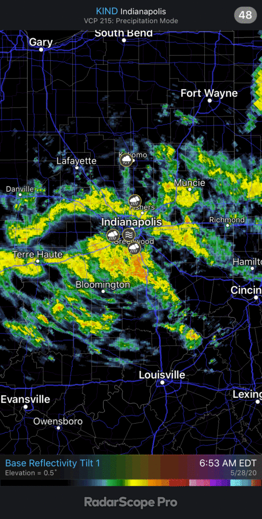
The best opportunity for widespread rain over the next week will take place today as the upper low impacts the region. With a tropical airmass in place, this feature will be able to produce a good soaking for most of central Indiana. Widespread moderate rain this morning will continue for the next few hours before being replaced with more scattered activity during the afternoon/ evening.
Most central Indiana neighborhoods can expect an inch of rain today with locally heavier totals.
The next feature we’ll contend with is the cold front itself and it’s still slated for a Friday passage. Scattered showers and storms will remain possible ahead of the boundary but coverage shouldn’t be nearly as widespread as what we’re seeing this morning. Once the front blows through tomorrow afternoon, much drier and cooler air will arrive and stick around for a few days.
Cool and refreshing Canadian air will arrive just in time for the weekend.
Dry conditions will stick around through the weekend and into early next week to result in perfect weather to get some of those outdoor chores knocked out before the warm, muggy stuff returns.
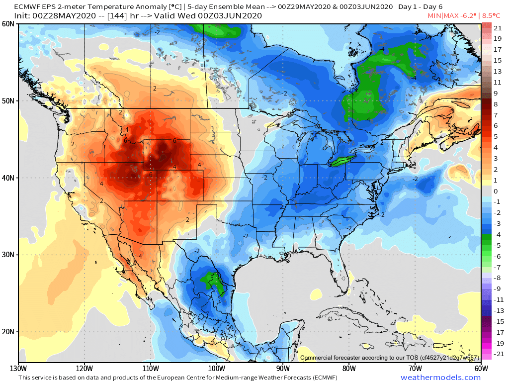
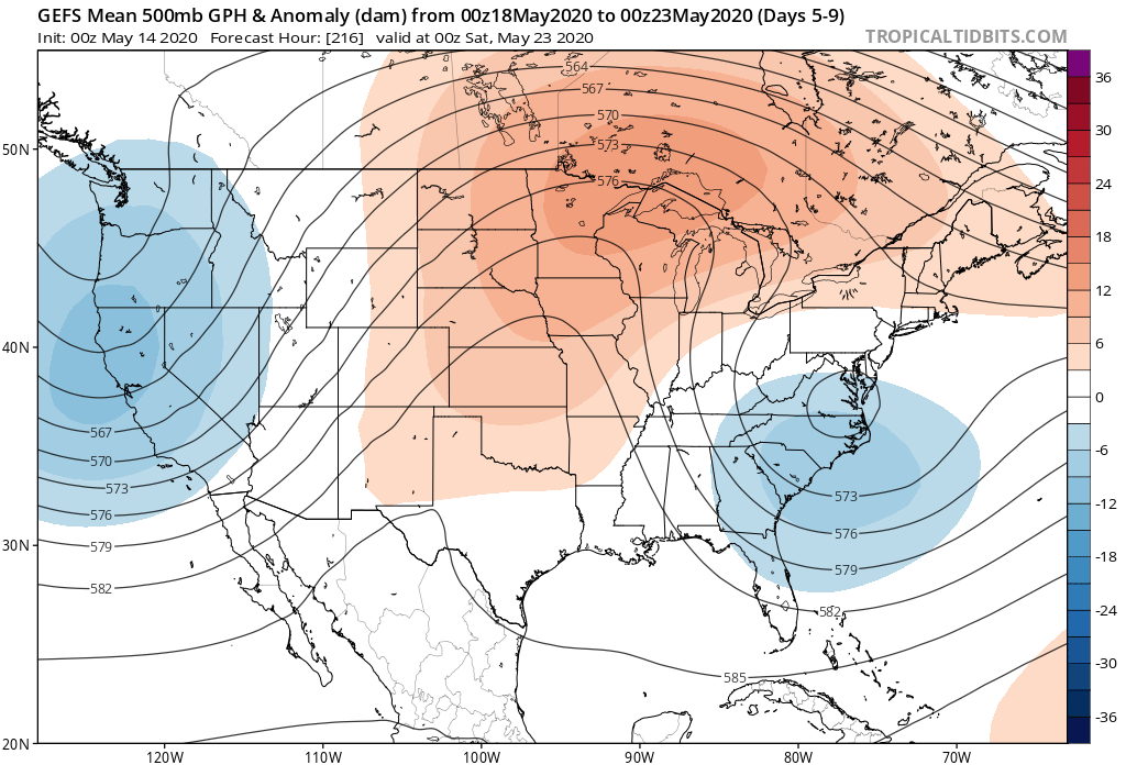
Speaking of that, as we look ahead, we’ll replace the refreshing air with a return of warmth and humidity during the 2nd half of next week. Note how the European ensemble shows the transition.
The JMA Weeklies (fresh in this morning) also show the warmth that looms through the better part of the 1st half of June.
We’ll have to keep close tabs on exactly where the upper level ridge sets up in the Week 2 time period. This will mean the difference between “splash and dash” storm coverage as the mugginess returns vs. more widespread, organized activity in what would be a northwest flow around the periphery of the ridge. Stay tuned.
I. After a cold and dry open to May, (Month-to-date, Indianapolis is running 8.4° below avg. and 1.24” below normal in the precipitation department) changes have arrived.
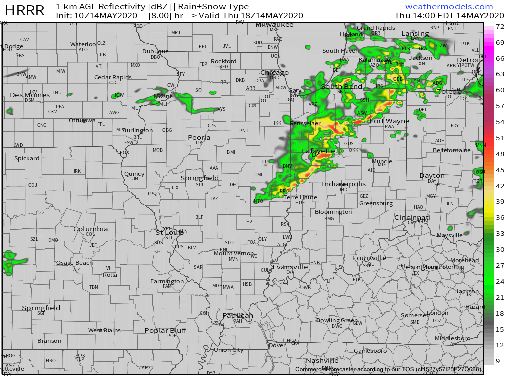
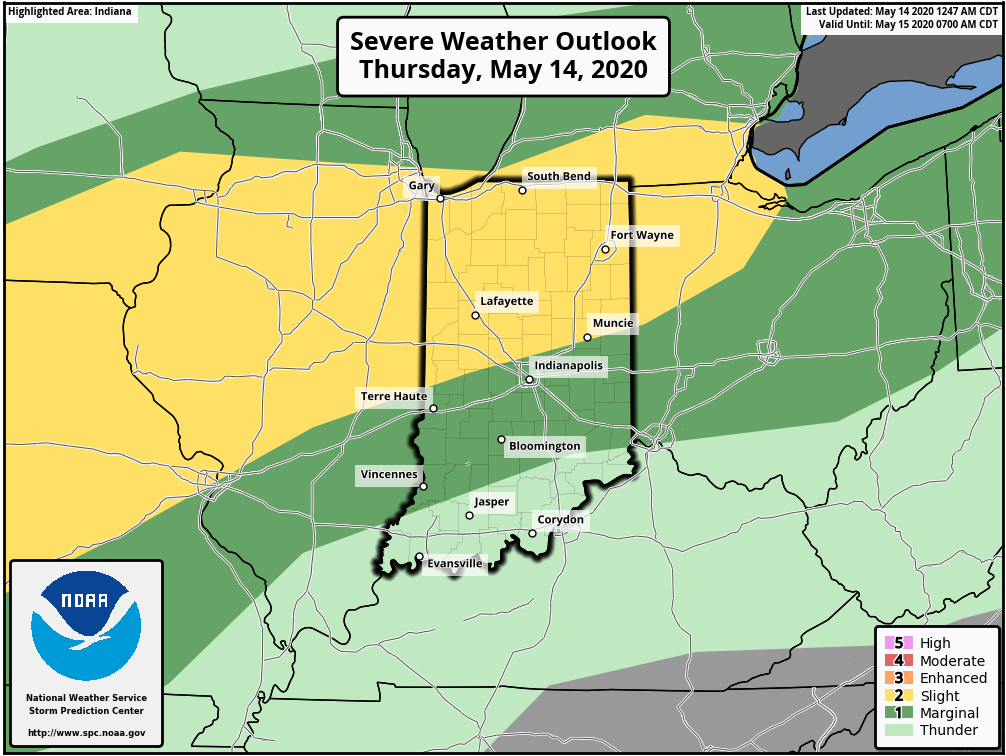
II. A warm front will lift north through the state today and deliver those warmer changes. The transition from cool to more of an early summer feel will be met with a couple rounds of storms today. Some of those storms will be strong to severe (damaging winds being the greatest concern), especially north of the city. Strongest storms should arrive across the northern half of the state during the early to mid afternoon hours.
III. A “half-n-half” weekend is expected. After a wet Friday, drier air is expected to arrive to help us out Saturday. Showers and storms will return Sunday courtesy of a cold front and associated surface low. Locally heavy rainfall will be possible Friday & Sunday and when you add in what falls today, most of the state from the city and points north can expect widespread 2”-2.5” with locally heavier amounts.
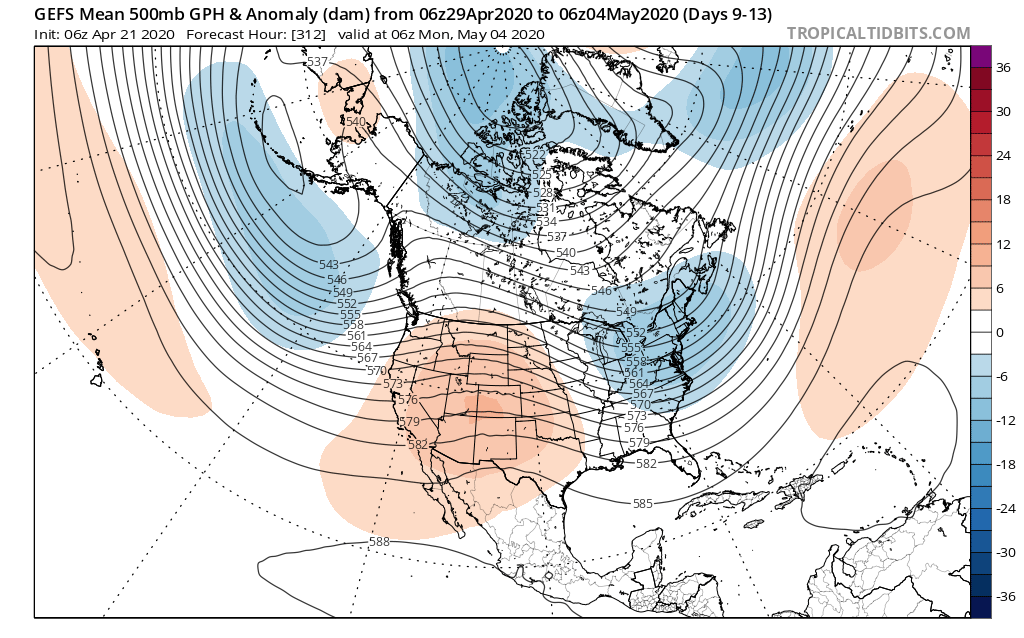
IV. An area of low pressure and upper level trough is now shown to “cut off” over the Mid-Atlantic region in the medium range period. This is forecast to dramatically cool the Monday through Thursday time frame (instead of 80s, we’re now talking upper 50s, 60s and low 70s during the period). This is worth keeping an eye on as models can struggle handling these kind of features, but as it stands now, after a brief encounter with warmth this weekend, it doesn’t appear as if we’ll get back to the heat until Memorial Day weekend.
With a little over a week left in April, thoughts continue to focus more and more on May. While our official monthly outlook will come out later next week, we did want to present our early thoughts on the first week of the month.
In short, a rather persistent upper trough is expected to dominate the eastern 1/3 of the country into the 1st week of the month. This should keep things cooler than normal, overall.
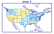
This also lines up perfectly with Phase 2 of the MJO in early May. (After a week of disagreement, model data now agrees that the MJO should “flirt” with Phase 3 before cycling back into Phase 2 early May). We note this favors cooler than normal temperatures across our portion of the country.
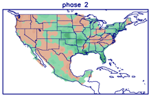
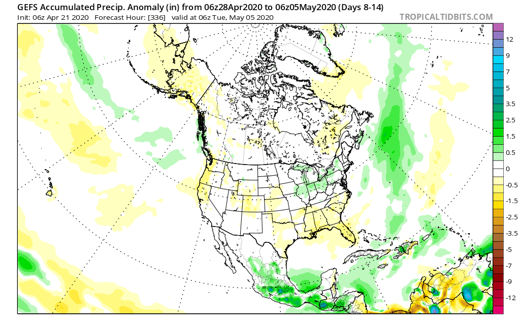
From a precipitation perspective, there aren’t particularly strong signals for wetter/ drier than average conditions with Phase 2 in May- at least for the Ohio Valley.
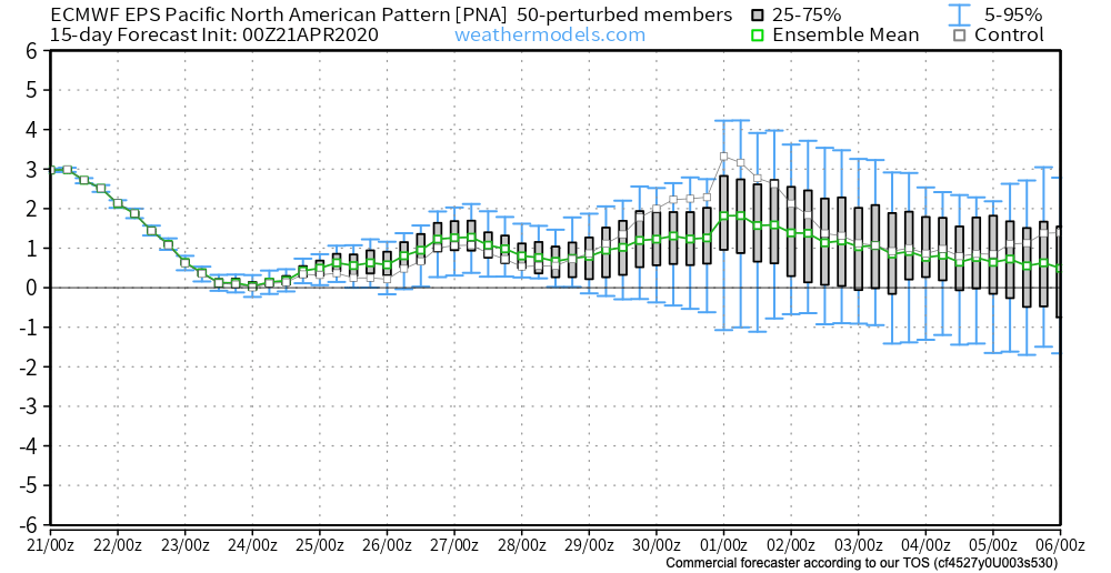
The positive PNA, however, can support a bit more of an active storm track through our region and that’s what model data is showing from this distance.
The positive PNA, of course, also supports cooler than normal temperatures across our portion of the country…
You must be logged in to view this content. Click Here to become a member of IndyWX.com for full access. Already a member of IndyWx.com All-Access? Log-in here.