Another Bout Of Rush Hour Wintry Mix; Longer Range Talk…

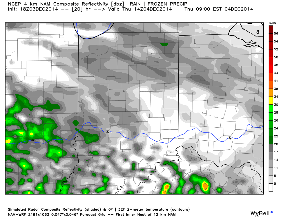
We think we’re dealing with another round of light freezing drizzle and a wintry mix for the Thursday morning commute.  Plan to allow extra travel time.

Forecast radar Thursday morning suggests freezing drizzle and a light wintry mix is in play across central Indiana.

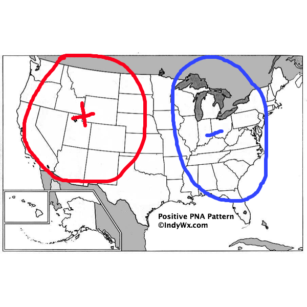
There’s some longer term data that’s in stark contrast from what a positive PNA should produce (yet alone a strong positive PNA).  Typical positive PNA pattern should promote an eastern trough and associated colder than normal pattern as drawn below:

PositivePNA

Needless to say, we disagree strongly with the NAEFS and GFS ensembles:

2014120312_054@007_E1_north@america_I_NAEFS@TEMPERATURE_anomaly@probability@combined@week2_186

Regardless, the future will tell!  

Warm And Windy For Colts Vs. Redskins…

Colts v. Redskins Forecast Prepared For:

The Indiana Sports Report

11.30.14

Happy game day Colts fans!  A strong southwesterly air flow is creating windy conditions for tailgating this morning, but the upside is that temperatures are in the lower 60s!  A cold front has it’s eyes set on the region and will arrive this afternoon and evening.  This will lead to better afternoon rain chances and a MUCH colder feel as we progress through the evening.  Visit IndyWx.com for “Indy’s Behind The Scenes Weather” all season long!  Go Colts!

Tailgate Weather

Kickoff Weather

Heading Home

Mostly Cloudy Scattered Showers Showers
Temp: 61-64 Temp: 61 Temp:  60
Wind:  SW 20-30 MPH Wind: SW 20-30 MPH Wind:  SE 20-30 MPH
Precip: 0.00” Precip: 0.05”  Precip:  0.05”
Scattered showers will arrive around kickoff, but heavier showers should hold off until the cold front moves in later this evening, per this forecast radar image.

ISRlogo2-280x121

Briefly Milder This Weekend, But Rain Chances Included…

Sat.

Sun.

Mon.

Tue.

Wed.

Thr.

Fri.

 Status-weather-showers-day-icon

 Status-weather-showers-scattered-icon

 Status-weather-clouds-icon

 Status-weather-clouds-icon

 Status-weather-showers-day-icon

 Status-weather-showers-scattered-icon

 Status-weather-clouds-icon

31/ 54

43/ 60

27/ 43

25/ 39

34/ 48

39/ 49

30/ 40 

Milder Air, But Rain Chances Increase…Many will welcome a milder southwesterly air flow this weekend.  While this will serve to help give temperatures a significant boost from what we’ve dealt with practically the whole month of November, it’ll also provide increasingly cloudy skies and the chance of sprinkles/ light rain showers by afternoon and evening.

Sunday will be even milder as highs reach towards the 60 degree mark.  A cold front will approach the area Sunday afternoon and evening and provide a better chance of showers and colder air to open the new work week.

Have The Dramamine Handy…We’re in the beginning stages of a pattern change that’ll promote at least “attempts” of milder air in the coming 7-10 days.  That said, cold highs will remain across the northern tier and present challenges in both the temperature forecast, but also precipitation timing in the back half of this forecast period.  In the longer term we want to be very clear that signals suggest mid and late December feature a cold and wintry pattern returning.

As we move into the mid and late week stretch plan for possible changes.  There are challenges that abound, but for now our best meteorological take will feature increasing clouds Wednesday with light showers arriving by evening.  This would be followed by steadier rains Thursday before drier and colder air returns to wrap up the work week.  Stay tuned; it’s a tough pattern, as is usually the case during the transitional seasons.

News And Notes: Bill will be on WIBC with Ray Steele this morning around 7:30.  Be sure and tune in to hear a little weather chit-chat and a lot of talk about tonight’s Iron Bowl… War Eagle!

Upcoming 7-Day Precipitation Forecast:

  • 7-Day Rainfall Forecast: 0.50″ – 1″
  • 7-Day Snowfall Forecast: 0.00″

Catching Up And Looking Ahead…

From the IndyWx.com family to yours, we wish you a very happy Thanksgiving! Thank you for taking the time to read our content daily and for all of your support…

You must be logged in to view this content. Click Here to become a member of IndyWX.com for full access.  Already a member of IndyWx.com All-Access?  Log-in here.