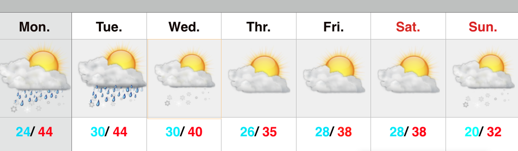
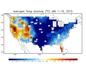
We wanted to touch briefly on the longer range weather pattern as we’ve been answering questions this weekend out there concerning what lies ahead. Ultimately, the good Lord above is the only one who knows tomorrow and this idea we have very well may be the wrong one. However; we still see a lot of winter in this weather pattern. The combination of below average snowfall to date, combined with milder air the past 24 hours has led some winter lovers into a panic. Despite the past 24 hours, let’s remember where we are for the month of January through the first half:
Now let’s compare this to the infamous January 2014:
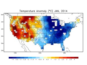
So far, this January the cold is more widespread across the nation. Additionally, through the first half of January, IND is actually running colder than last January. Many remember the brutal cold following the major winter storm early last January. Let’s also remember that a few days after that snow and cold we were dealing with much milder air and rain- a bonafide January thaw.
That brings us back to the present and our current January thaw. Looking back through the record books indicate even the coldest Januarys on record have “thaws.” What’s perhaps more impressive is that the end of this year’s thaw appears to be seen really before it even begins.
There are so many different drivers trying to take the wheel this winter it, admittedly, makes for an incredibly challenging time of things forecasting. That said, should we see the “stars align” (negative AO, negative NAO, positive PNA) in the coming weeks, this is the type scenario that could carry winter deep into spring.
In the shorter term, as of now we see no reason to abandon the idea the cold reloads to close January and open February. It’s possible that some weather outlets lean heavily on particular model runs and base their mid to long range forecast accordingly. While we agree you have to supplement some of that data into your mid and long range forecast, this is the type pattern than can make for risky business putting all the eggs in one basket. (We also suggest any outlets leaning solely on operational and ensemble output are in need for a serious dose of dramamine). Instead, we prefer a blend of the above with the foundation being a combination of a nearly ideal SST profile for wintry times continuing and big-hitter analogs. It must also be noted that we have to keep the current AO/ PNA state in the back of our mind.
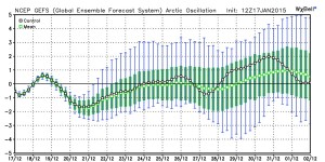
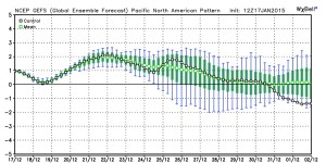
Speaking of those teleconnections… The current AO and PNA leave a lot to be desired for winter lovers in the longer range:
That said, it should be noted the first two weeks of January cold was in the face of teleconnections that screamed of a warm pattern and a MJO phase that was also mild.
Perhaps the bigger driver here is the surface temperature profile in the PAC and ATL. Also note the modoki El Niño.
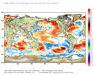
That warmer water sitting across the northeast Pacific Ocean promotes ridging into the PAC NW and AK. In return the upper level winds tap available arctic air and send it southeast (see the first two weeks of January).
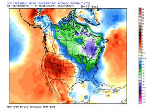
In the mid range, ensemble data is bullish on this aforementioned pattern returning after the very brief January thaw.
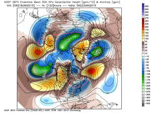
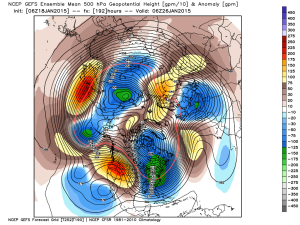
The sensible weather that should result the upcoming 10-12 days? An active pattern and one that’s very challenging with that northwest flow (we’ll be on clipper watch), biased colder than average. In fact, the GFS ensembles aren’t too shy about eastern cold week 2.
Let’s watch things unfold in the coming couple of weeks. Make it a great day and GO COLTS!