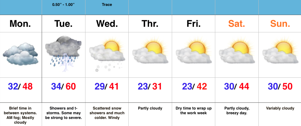
Strong To Severe Storms Tuesday Afternoon-Evening…Today is a day in between storm systems. We’ll deal with morning fog in spots (some freezing fog is being reported north and northwest of Indy this morning) and mostly cloudy skies. It’ll be colder when compared to the weekend, but still warmer than average.
All eyes for this forecast package remain locked on Tuesday. It’s still shaping up to be an active day, with strong to severe thunderstorms likely. We bracket 3p-11p for the most likely time frame of thunderstorms across central IN. Damaging straight line winds are of greatest concern, but caution a few embedded cells will be capable of producing a tornado.
Things turn much colder Wednesday and with lingering moisture, a few snow showers will be a good bet.
We turn much quieter to wrap up the week and head into Super Bowl Sunday.
Severe threat from the Mid South to the Ohio Valley Tuesday
Impactful winter event developing late in the period
Summary: The forecast period will begin with strong ridging across the eastern half of the CONUS, while a significant trough digs across the west. That trough will lift northeast through the middle of the upcoming work week before re-amplifying over the upcoming weekend into early week 2 across the Plains and Ohio Valley region.
Sensible Impacts: A significant storm system will move off the Rockies and into the Plains Monday. The surface low will track northeast from SE CO Monday night into SW MI Tuesday night. To the north and northwest of the surface low, heavy snow and blizzard conditions will impact areas from CO, KS, NE, IA, MN, and WI. South and southeast of the surface low track, strong to severe thunderstorms will rumble through the lower MS Valley, TN Valley, and Ohio Valley Monday night into Tuesday night. All modes of severe weather will be possible, including tornadoes.
We’ll need to keep a close eye on the potential of a clipper system diving SE across the N. Plains and upper Ohio Valley over the upcoming weekend, but the bigger event appears to be a developing winter storm threat centered on the end of the period (2/8-2/10 time period). There are, obviously, a lot of details to sort through, but an impactful winter event is very possible across the Ohio Valley towards the end of the forecast period.
Temperature Anomalies: The period will open much warmer than normal, but transition cold, and eventually colder than normal by the end of the period across the forecast region.
Anomalous warmth will engulf the Ohio Valley to open the forecast period. Source: Penn State E-WallThe pattern shifts colder than normal towards the end of the period across the Plains into the southeast. Source: Penn State E-Wall
Precipitation: A stripe of heavy snows (10″-15″) will fall from CO, NE, IA, southern MN, and WI with the initial early week storm. .5″-1.5″ of rain will fall across the Southeast, TN, and OH Valley regions (locally heavier totals where strong storm train). Overall, quieter times return mid and late week for the forecast region before the next potential strong storm develops late in the period.
For private weather consulting and more detailed ag-weather updates, please e-mail bill@indywx.com.
You must be logged in to view this content. Click Here to become a member of IndyWX.com for full access. Already a member of IndyWx.com All-Access? Log-in here.
Taste Of Spring Today, But Winter Roars Back…A quick scan over the 7-day above shows the busy times that lie ahead. Our suggestion to you? Enjoy today’s sunshine and early taste of spring! Let us worry about what lies ahead. You’re welcome! 😉
We’ll add some mid and high level cloudiness into the picture later today and those clouds will lower and thicken tonight. Tomorrow, though still warm, won’t be as nice. Look for cloudy skies, scattered showers, and breezy SW winds.
We’ll be in between systems Monday with a generally dry day and a bit cooler, though still above average for this time of year.
A strong area of low pressure will quickly move from the central Plains Monday night into the Great Lakes Tuesday night. We’ll be on the warm side of this storm’s track and will note a dramatic shift in our wind to the SW early Tuesday that will help temperatures zoom into the lower 60s Tuesday. The downside? We’ll have to monitor things closely for strong to severe thunderstorm potential.
The area of low pressure will swing a cold front through here late Tuesday night and send temperatures into a free-fall for mid week. We’ll have to watch things closely as we’ll be in an active NW flow heading into next weekend. You know the drill by now- models struggle picking up pieces of energy plenty capable of producing accumulating snow from this distance with that potentially active NW flow.
Longer term, winter fans should really like what we’re seeing. We’ll have a more extensive post on this later in the weekend, but the pattern shaping up is one that’ll feature the more sustained cold pattern (relative to normal) in the middle of the country through most of February, including the Ohio Valley. A busy interior storm track is also noted in the coming weeks. Far too early for specifics, but it’s a pattern plenty capable of leading to above normal monthly snowfall in our neck of the woods. Again, more later!
You must be logged in to view this content. Click Here to become a member of IndyWX.com for full access. Already a member of IndyWx.com All-Access? Log-in here.
 Highlights:

