Category: Unseasonably Warm

Northern Branch To Be Dealt With; Complicated Wintry Pattern Next Week…

A very busy, and WINTRY, pattern awaits next week. There are more questions than answers right now concerning the all-important specifics, but modeling is leaning more towards the northern stream dominating the pattern.  While this takes the chances of one big, phased storm out of the equation, challenges abound, and ultimately the sensible weather may be very similar once everything is said and done, locally.

The upcoming weekend will be tranquil and mild.  Continue Super Bowl prep and enjoy it.

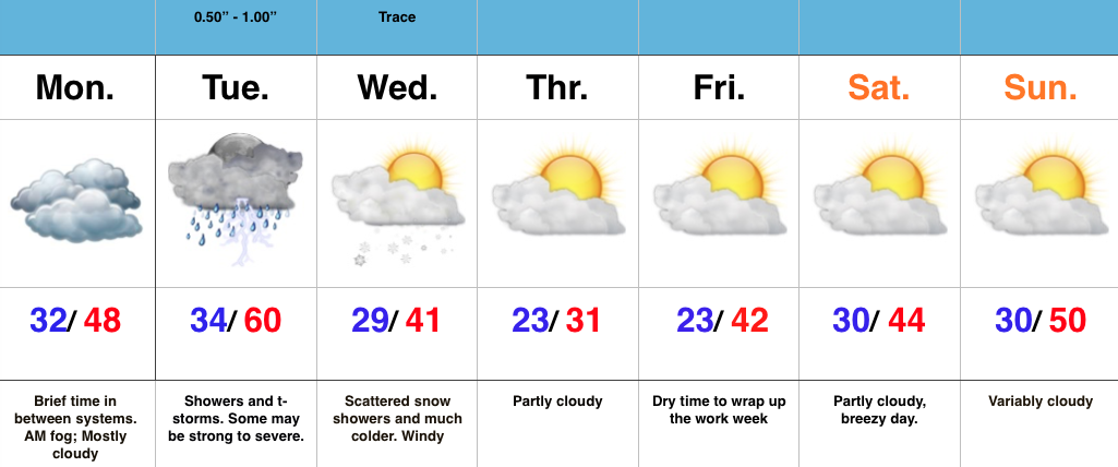
Heading into Monday, an arctic cold front will move through the Ohio Valley and may be accompanied by a band of precipitation- likely rain to snow.

As we move into Monday night and Tuesday, forecast models are liking the idea of low pressure developing over the Great Lakes region and suggest this low slowly moves south into the Ohio Valley Tuesday night into Wednesday.  At the same time, individual “spokes” of energy, or upper air disturbances, will move through the area in the fast, cold northwest flow.

Nstream

500mb pattern Monday night. Source: Tropicaltidbits.com

GFS ensembles. Source: Weatherbell.com

GFS ensembles. Source: Weatherbell.com

From a temperature perspective, what at one time (now) was a warm pattern, suddenly turns much colder than normal (early next week).

2

3Stay tuned as we move forward and continue to fine tune the details.  As of now, we’re confident on an accumulating snow event early-mid next week, but have a long way to go concerning details on timing, duration, etc.

Video update later this evening.  Make it a great Wednesday!

Permanent link to this article: https://indywx.com/northern-branch-to-be-dealt-with-complicated-wintry-pattern-next-week/

Tuesday Evening: Stormy For Some Tonight; Wintry Next Week…

You must be logged in to view this content. Click Here to become a member of IndyWX.com for full access.  Already a member of IndyWx.com All-Access?  Log-in here.

Permanent link to this article: https://indywx.com/tuesday-evening-stormy-for-some-tonight-wintry-next-week/

Monday Evening Video Update…

You must be logged in to view this content. Click Here to become a member of IndyWX.com for full access.  Already a member of IndyWx.com All-Access?  Log-in here.

Permanent link to this article: https://indywx.com/monday-evening-video-update-6/

Strong To Severe Storms Tuesday PM…

Screen Shot 2016-02-01 at 7.03.14 AMHighlights:

  • Morning fog in spots
  • Strong Tuesday storms
  • Mid week snow showers
  • Quiet end to the week

Strong To Severe Storms Tuesday Afternoon-Evening…Today is a day in between storm systems. We’ll deal with morning fog in spots (some freezing fog is being reported north and northwest of Indy this morning) and mostly cloudy skies.  It’ll be colder when compared to the weekend, but still warmer than average.

All eyes for this forecast package remain locked on Tuesday.  It’s still shaping up to be an active day, with strong to severe thunderstorms likely.  We bracket 3p-11p for the most likely time frame of thunderstorms across central IN.  Damaging straight line winds are of greatest concern, but caution a few embedded cells will be capable of producing a tornado.

Things turn much colder Wednesday and with lingering moisture, a few snow showers will be a good bet.

We turn much quieter to wrap up the week and head into Super Bowl Sunday.

Permanent link to this article: https://indywx.com/strong-to-severe-storms-tuesday-pm/

10 Day Ag-Weather Outlook…

10 Day AG-Weather Outlook

Issued: 01.31.16

Forecast period: 02.01.16 – 02.10.16

Focal Items:

  • Plains blizzard Days 1-3
  • Severe threat from the Mid South to the Ohio Valley Tuesday
  • Impactful winter event developing late in the period

Summary:  The forecast period will begin with strong ridging across the eastern half of the CONUS, while a significant trough digs across the west. That trough will lift northeast through the middle of the upcoming work week before re-amplifying over the upcoming weekend into early week 2 across the Plains and Ohio Valley region.

Sensible Impacts:  A significant storm system will move off the Rockies and into the Plains Monday.  The surface low  will track northeast from SE CO Monday night into SW MI Tuesday night.  To the north and northwest of the surface low, heavy snow and blizzard conditions will impact areas from CO, KS, NE, IA, MN, and WI.  South and southeast of the surface low track, strong to severe thunderstorms will rumble through the lower MS Valley, TN Valley, and Ohio Valley Monday night into Tuesday night.  All modes of severe weather will be possible, including tornadoes.

We’ll need to keep a close eye on the potential of a clipper system diving SE across the N. Plains and upper Ohio Valley over the upcoming weekend, but the bigger event appears to be a developing winter storm threat centered on the end of the period (2/8-2/10 time period).  There are, obviously, a lot of details to sort through, but an impactful winter event is very possible across the Ohio Valley towards the end of the forecast period.

Temperature Anomalies:  The period will open much warmer than normal, but transition cold, and eventually colder than normal by the end of the period across the forecast region.

Screen Shot 2016-01-31 at 5.25.30 PM

Anomalous warmth will engulf the Ohio Valley to open the forecast period. Source: Penn State E-Wall

The pattern shifts colder than normal towards the end of the period across the Plains into the southeast. Source: Penn State E-Wall

The pattern shifts colder than normal towards the end of the period across the Plains into the southeast. Source: Penn State E-Wall

Precipitation:  A stripe of heavy snows (10″-15″) will fall from CO, NE, IA, southern MN, and WI with the initial early week storm.  .5″-1.5″ of rain will fall across the Southeast, TN, and OH Valley regions (locally heavier totals where strong storm train).  Overall, quieter times return mid and late week for the forecast region before the next potential strong storm develops late in the period.

For private weather consulting and more detailed ag-weather updates, please e-mail bill@indywx.com.

Permanent link to this article: https://indywx.com/10-day-ag-weather-outlook/