
You must be logged in to view this content. Click Here to become a member of IndyWX.com for full access. Already a member of IndyWx.com All-Access? Log-in here.
Category: Unseasonably Warm
Permanent link to this article: https://indywx.com/indy-500-and-memorial-day-weekend-video-update/
May 24
Turning Much More Humid…
 Highlights:
- Oppressive feel develops
- Scattered storms to close the week
- Less storm coverage for the 500 and Memorial Day
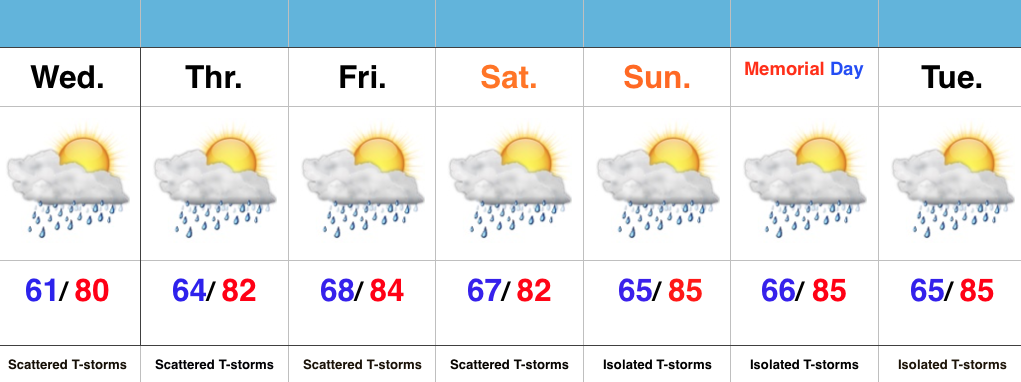
Ready To Sweat? A much more humid and oppressive feel will develop Wednesday (dew points likely surge to 70 by afternoon). Along with the muggy air mass, we expect scattered showers and embedded thunderstorms to develop. We’ll maintain mention of scattered storms into the weekend, but want to stress that these won’t be uniform in the least. That said, with all of the moisture in the air, stronger storms will be capable of producing locally heavy rainfall.
We continue to keep a close eye on the data for Sunday and Monday. Thankfully, latest indications suggest we see an overall decrease in aerial coverage of showers and storms both days. We’ll call it “isolated” for now. It’ll be plenty hot and humid.
Permanent link to this article: https://indywx.com/turning-much-more-humid/
May 23
Not As Bad As It May Look…
 Highlights:
- Dry feel turns much more humid
- Splash and dash storms, but many dry hours
- Warm, humid Memorial Day/ Race weekend
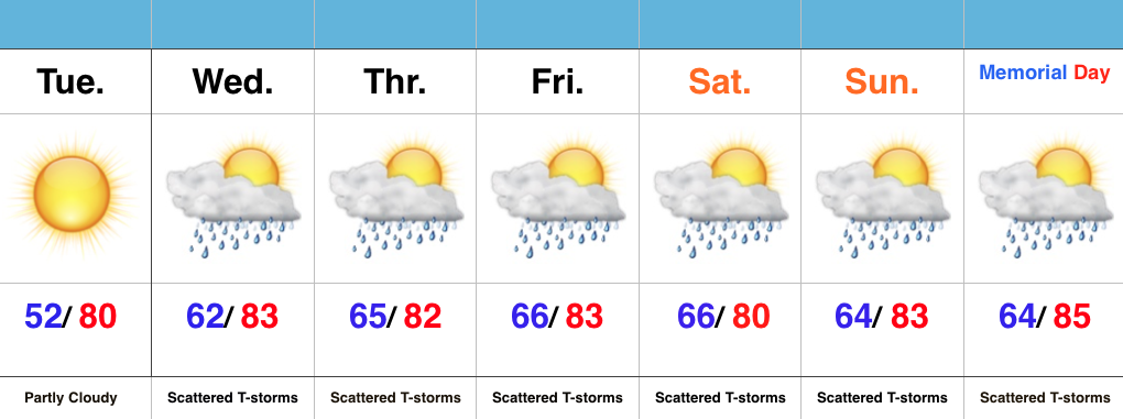
One More Dry Day…High pressure is scooting away from the region, but will remain close enough to supply central IN with dry conditions Tuesday. Though warm, we’ll enjoy one more day with dry air in place.
A SW wind shift will deliver an increasingly moist air mass for mid week, continuing into the long holiday and race weekend ahead. In fact, dew points will surge to readings around 70 (downright oppressive). While there will be times of scattered showers and thunderstorms, there will also be many dry hours, as well. We continue to keep an eye on Wednesday for the potential of a strong to severe storm.
As we continue to grow closer to the holiday and race weekend, questions continue to increase around the forecast specifics, and rightfully so. While we need to be prepared for an afternoon/ evening storm, these will be scattered and there will be “haves and have nots” when it comes to storm/ rain activity over the balance of the upcoming forecast period. Again, we want to emphasize there should be plenty of dry time.
Permanent link to this article: https://indywx.com/not-as-bad-as-it-may-look/
May 22
Feeling Like Summer…
 Highlights:
- Dry open to the week
- Warming up and turning humid
- Storm chances mid week on
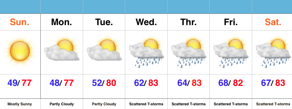
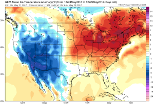
Beautiful Open To The Week…High pressure and a dry air mass will result in lots of sunshine to open the week. After a chilly first few weeks of May, we’ll see improvements in the mercury this week. A dry air mass will still result in cool overnight lows through Tuesday morning, but we’ll shift to a much more humid regime for mid and late week. Additionally, temperatures will continue to climb into the lower 80s for highs. Prepare to sweat.
The increased moisture and an approaching frontal boundary will help ignite scattered showers and thunderstorms for the second half of the week. We also have a close eye on Wednesday for the potential of strong to severe thunderstorms. While it won’t rain the entire time, prepare for “splash and dash” showers and storms into the important Memorial Day/ Indy 500 weekend…
Permanent link to this article: https://indywx.com/feeling-like-summer-3/
May 21
Busy Week Ahead Turns Active In The Weather Department…
After a damp and chilly open to the weekend, drier air began to infiltrate the region this afternoon and led to a brighter/ warmer finish to the day. We’ll add more sunshine and tack on a few degrees to the afternoon high on Sunday. It’ll be a phenomenal weather day across central IN, thanks to high pressure. Get out and enjoy it!
 Dry and sunny weather will greet us to open the new work week, along with temperatures that will approach the 80 degree mark by Tuesday. Have yard work to get caught up on? Take advantage of the early week weather.
Things will begin to change towards an unsettled regime as early as Tuesday evening/ Wednesday as the region gets into an increasingly moist southwesterly air flow.
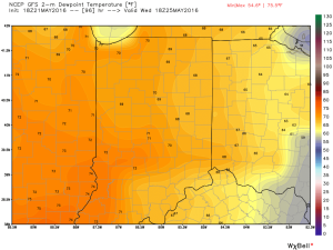
 As such, we’ll increase the chances of showers and thunderstorms in our mid week forecast. It’ll also be a much more humid feel of things (really for the first time this year) as surface dew points surge into the upper 60s to lower 70s. (In other words, “oppressive”).
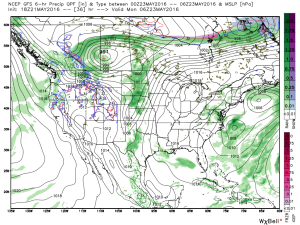
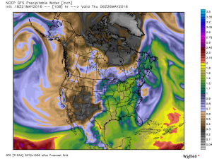
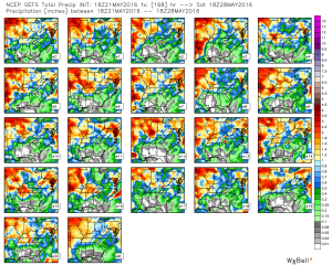
 Factor in PWATs (precipitable water values) zooming to 1.5″-1.8″ and the threat is there for localized heavy downpours around mid week.
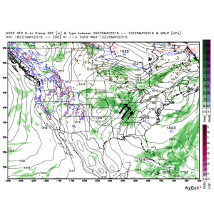
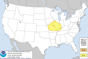
 Additionally, we also note the Storm Prediction Center (SPC) has placed western sections of our forecast area in a risk of severe weather Wednesday. We’ll keep a close eye on things.
 As we progress into the late week period and on into the long holiday/ race weekend, a warm, humid, and unsettled time of things is expected to continue. It’s tough to pinpoint specifics from this distance, but just keep note of the threat of thunderstorms into and through the upcoming busy weekend, along with warm (highs in the lower to middle 80s; lows in the upper 60s) and humid conditions.
Permanent link to this article: https://indywx.com/busy-week-ahead-turns-active-in-the-weather-department/