Category: Unseasonably Warm
Today into Wednesday will offer up more of what we’ve grown so accustomed to over the past several days- incredibly humid air, along with scattered heavy thunderstorms. Similar to days past, the humid, “heavy” nature to our air will help fuel localized torrential downpours.
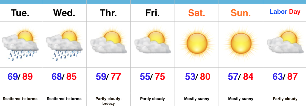
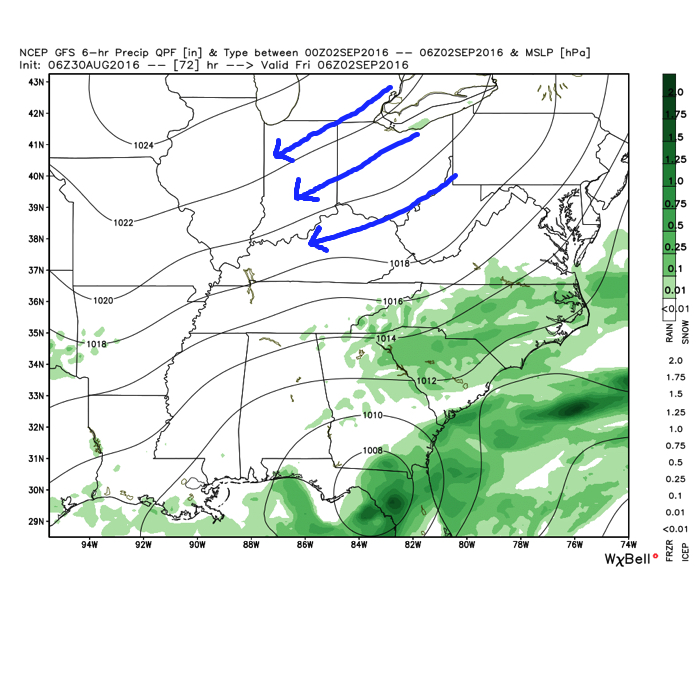
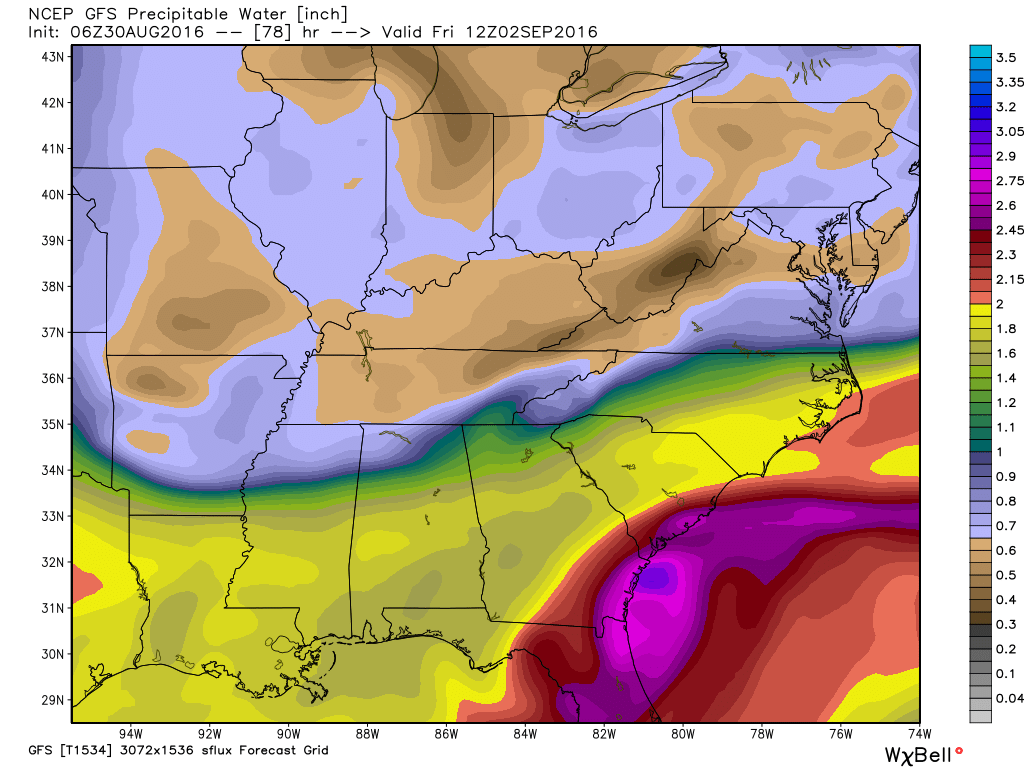
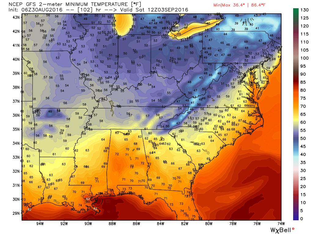
Thankfully, the hour glass has been “flipped” and time is running out on the humid air mass. In fact, as early as Thursday morning, we’ll notice a huge change. A northeast flow will provide a much drier brand of air and temperatures will also cool significantly. Several mornings (Thursday through Sunday) will feature lows in the 50s with highs in the 70s. Lows into the upper 30s will drive southeast into the high ground of the beautiful east TN mountains.
 Eventually, our air flow will back around to the southwest and help push Labor Day into the “hot” territory. Highs in the upper 80s to around 90 will be common for Labor Day, itself.
The balance of the first half of September looks warm, but there are indications for changes to begin showing up towards mid to late month that would lead towards more sustained, consistent pushes of cool…
Permanent link to this article: https://indywx.com/2016/08/30/changes-ahead/
 Highlights:
- Scattered storm chances remain for now
- Drier and much cooler air on deck
- Dry, but hot Labor Day looms
Breath Of Fresh Air Awaits…Once we get through the next (48) hours, a much more pleasant, early fall-like, air mass awaits. Beforehand, we still have plenty of heat and humidity to deal with, along with the all-too-familiar mention of scattered (but heavy) thunderstorms. Thankfully, a cold front will push through the state Wednesday night into Thursday morning and usher in a much cooler and drier air mass to wrap up the work week and head into the long holiday weekend. High pressure will supply a refreshing northeasterly flow Thursday into Friday, supporting breezy conditions and much cooler air. It’ll be the type air mass that will make you take notice fall isn’t that far off, after all.
As we push closer to Labor Day, itself, our air flow will back around to the southwest and assist with a warmer and increasingly moist brand of air for the holiday, into the majority of the Week 2 period…
Upcoming 7-Day Precipitation Forecast:
- Snowfall: 0.00″
- Rainfall: 0.50″-0.75″ (locally heavier totals)
Permanent link to this article: https://indywx.com/2016/08/29/well-earned-break-from-the-heat-humidity-on-deck/
-
Filed under Forecast Discussion, Forecast Models, Labor Day Weekend, Rain, Summer, T-storms, Tropics, Unseasonably Cool Weather, Unseasonably Warm, Weather Videos
-
August 27, 2016
You must be logged in to view this content. Click Here to become a member of IndyWX.com for full access. Already a member of IndyWx.com All-Access? Log-in here.
Permanent link to this article: https://indywx.com/2016/08/27/video-talking-storm-chances-and-briefly-cooler-air/
 Highlights:
- Scattered weekend storms
- Humid air mass
- Less storm coverage early next week
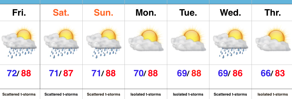
Air You Can Wear…A very warm, moist, and unstable air mass will remain in place across the region this weekend. While storms will be scattered, the moisture-laden air will help promote locally heavy storms at times. Get used to heat indices in the mid-upper 90s into early next week. Yuck!
Storm coverage will be on the decrease, overall, as we open the new work week. That said, we have to maintain isolated coverage. A weak boundary will slip through central IN the middle of next week and lead to scattered to numerous storms Wednesday.
In the tropics, Invest 99L remains at the forefront. There are many more questions than answers at this time, but if the disturbance (somehow, someway) can make it into the southeastern GOM early next week, conditions will be much more favorable for development.
Upcoming 7-Day Precipitation Forecast:
- Snowfall: 0.00″
- Rainfall: 0.75″-1.25″ (locally heavier amounts)
Permanent link to this article: https://indywx.com/2016/08/26/tropical-feel-this-weekend/
-
Filed under Dew points, Forecast Discussion, Forecast Models, Rain, Summer, Sunset, T-storms, Tropics, Unseasonably Cool Weather, Unseasonably Warm, Weather Videos
-
August 23, 2016
You must be logged in to view this content. Click Here to become a member of IndyWX.com for full access. Already a member of IndyWx.com All-Access? Log-in here.
Permanent link to this article: https://indywx.com/2016/08/23/video-so-long-pleasant-air-storm-chances-return/
 Highlights:
- Dry pattern continues today
- Mid week storms
- Questions abound this weekend
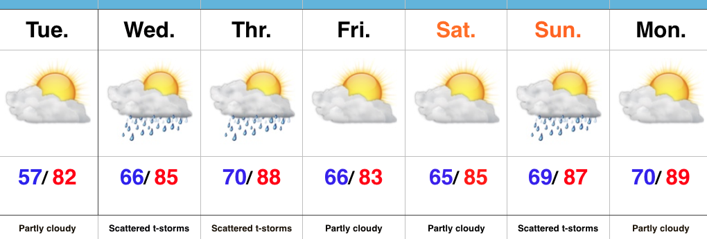
Heat And Humidity Return…High pressure will give way to an approaching cold front as we progress from early to mid week. Ahead of the front, a southwest air flow will transport an increasingly warm and muggy air mass northward. It’ll, unfortunately, feel much more humid Wednesday and Thursday. With the frontal boundary nearby and the increased humidity, expect scattered to numerous thunderstorms Wednesday and Thursday (along with locally heavy downpours). A couple strong storms are also possible.
We still think drier air will press into central IN to wrap up the work week and head into the first half of the weekend. That said, moisture returns as early as Sunday and leads to a mention of thunderstorms, especially during the PM. Stay tuned as we continue to fine tune timing.
Upcoming 7-Day Precipitation Forecast:
- Snowfall: 0.00″
- Rainfall: 1.00″-1.50″
Permanent link to this article: https://indywx.com/2016/08/23/its-still-summer-after-all/
-
Filed under 7-Day Outlook, AG Report, Flooding, Forecast Discussion, Forecast Models, Heavy Rain, Summer, Unseasonably Cool Weather, Unseasonably Warm, Weather Videos
-
August 9, 2016
You must be logged in to view this content. Click Here to become a member of IndyWX.com for full access. Already a member of IndyWx.com All-Access? Log-in here.
Permanent link to this article: https://indywx.com/2016/08/09/video-weekend-heavy-rain-threat/
 Highlights:
- Sun-filled days
- Heat cranks up
- Late week questions
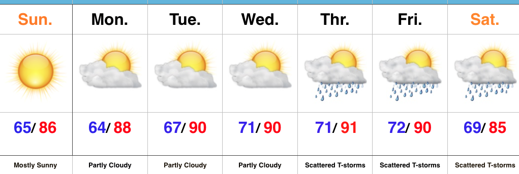
Turning Up The Heat…After a refreshing weekend, the heat returns later this week. Look for highs in the lower 90s with an oppressive feel to the air, as humidity builds. “Air you can wear” will be an appropriate forecast title come mid week. The forecast is easy through the midweek stretch with sunshine as the rule.
Things become more unclear as we approach the back half of the week and the weekend. We note the GFS is rather progressive in swinging a cold front through here with scattered showers and thunderstorms, followed by a significantly cooler/ drier air mass a week from today. On the other hand, the European solution is drastically different as it slows the front to a “crawl” coming through the Ohio Valley and also entrains GOM (Gulf of Mexico) moisture from the serious rain/ flood maker later this week across the Gulf states. It’s a significantly wetter look, locally, and a situation we’ll continue to keep a close eye on in the coming day, or two.
Upcoming 7-Day Precipitation Forecast:
- Snowfall: 0.00″
- Rainfall: 0.50″-1.00″
Permanent link to this article: https://indywx.com/2016/08/07/dry-and-turning-hot-watching-late-week/
You must be logged in to view this content. Click Here to become a member of IndyWX.com for full access. Already a member of IndyWx.com All-Access? Log-in here.
Permanent link to this article: https://indywx.com/2016/07/26/stormy-for-some-this-morning-transient-pattern-into-august/
 Highlights:
- Storm chances increase tonight-Monday morning
- Drier, cooler air on deck
- Widespread storms Thursday
Hang In There…It’s been a long couple of days with high heat and humidity, but relief is in sight. A cold front will move through the state Monday. Ahead of this front, a band of showers and thunderstorms will slide through Indiana. A few of these storms could be strong with locally heavy rain. Best chances of storms across central IN appear to arrive tonight and Monday morning, before transitioning to southern IN Monday afternoon. Drier air will arrive Tuesday into Wednesday.
Our next rain and storm chances are dialed up for Thursday and early indications suggest this could be a fairly widespread event. Though we’ll maintain rain chances next weekend, coverage will diminish when compared to Thursday. Temperatures will be much more tolerable than what we’re dealing with today.
Upcoming 7-Day Precipitation Forecast:
- Snowfall: 0.00″
- Rainfall: 0.75″-1.25″ (Locally heavier totals)
Permanent link to this article: https://indywx.com/2016/07/24/unsettled-but-a-better-feel-coming/


 Eventually, our air flow will back around to the southwest and help push Labor Day into the “hot” territory. Highs in the upper 80s to around 90 will be common for Labor Day, itself.
